
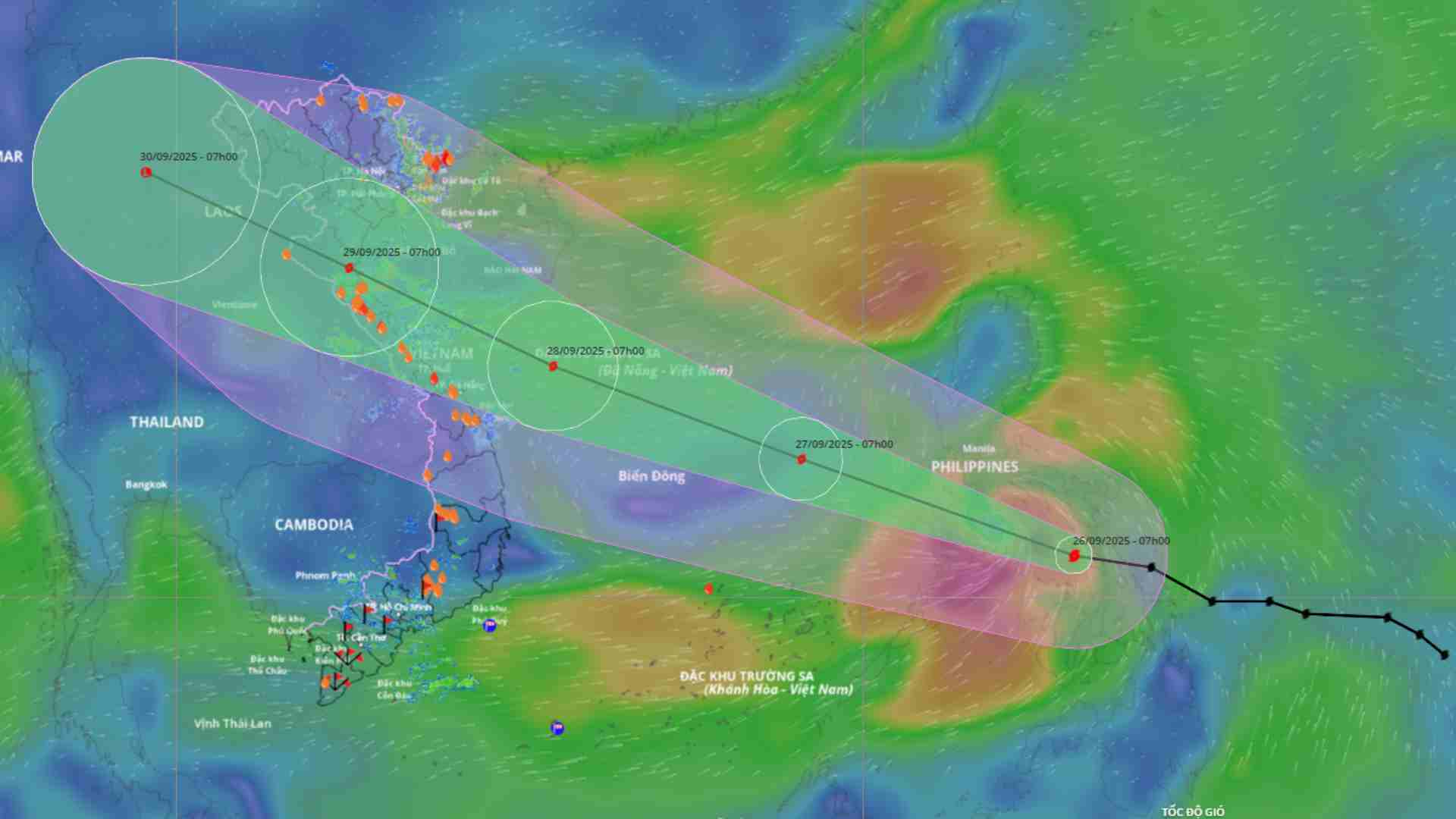
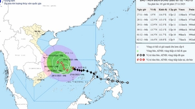
Updated location and path of Typhoon Bualoi at 2 PM on September 26th. Source: Vietnam Disaster Monitoring System.
On the afternoon of September 26th, Mr. Nguyen Hoang Hiep, Deputy Minister of Agriculture and Environment, chaired a meeting with ministries, agencies, and provinces to discuss the response to Typhoon Bualoi (Typhoon No. 10).

The Ministry of Agriculture and Environment held a meeting to respond to Typhoon Bualoi. Photo: Hanh Thom
Presiding over the meeting, the Deputy Minister of Agriculture and Environment emphasized that the simultaneous occurrence of two storms could create a multi-disaster phenomenon, leading to heavy losses of life, property, and infrastructure.
Speaking at the meeting, Mr. Mai Van Khiem, Director of the National Center for Meteorological and Hydrological Forecasting, said that in the early afternoon of September 26, the storm was over the central Philippines with an intensity of level 11, gusts of level 14, and moving at a speed of 30 km/h.
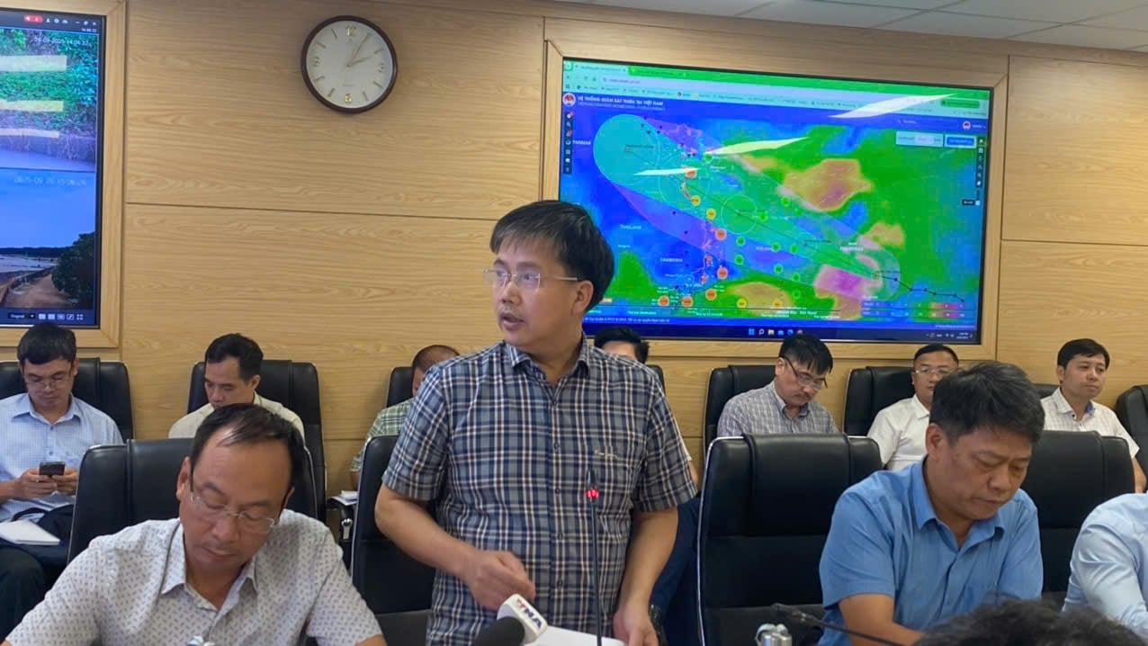
Mr. Mai Van Khiem, Director of the National Center for Meteorological and Hydrological Forecasting, provided information at the meeting. Photo: Hanh Thom
Forecasts indicate that by the evening of September 26th, the storm will enter the eastern part of the central South China Sea, becoming the 10th storm of 2025.
According to Mr. Khiem, Typhoon Bualoi moved very quickly at 25-35 km/h (twice as fast as a normal typhoon); reaching its strongest intensity at level 13, with gusts up to level 16 in the Hoang Sa Special Economic Zone on September 28.
It is expected to make landfall in Thanh Hoa and Ha Tinh provinces with intensity level 12, gusting to level 15, on the morning of September 29th.
With maximum intensity of level 13, gusts reaching level 15, and the potential to make landfall as strong as or even stronger than Typhoon Kajiki (Typhoon No. 5).
Update on the status of reservoirs and dikes.
According to the report from the Department of Dike Management and Disaster Prevention and Control on the situation of reservoirs and interconnected reservoirs in the Red River basin, the upstream water levels of the reservoirs at 11:00 AM on September 26th were as follows: Son La 214.14m (0.86m lower than the normal water level); Hoa Binh: 113.18m (3.82m lower than the normal water level); Tuyen Quang: 117.61m (2.39m lower than the normal water level); Thac Ba: 57.36m (0.64m lower than the normal water level).
The total remaining capacity of the reservoirs for flood control is 1,731.60 million m3, including: Son La: 712 million m3; Hoa Binh: 706 million m3; Tuyen Quang: 170.99 million m3; Thac Ba: 142.62 million m3. Currently, Thac Ba reservoir has two spillway gates open (since 13:30 on September 23).
The Northern region of Vietnam has 2,495 irrigation reservoirs, with an average storage capacity of 68-97% of their designed capacity. Currently, 137 reservoirs are damaged; 52 reservoirs are undergoing repair, upgrading, or new construction.
The North Central region has 2,323 reservoirs, with a capacity reaching 72-89% of their designed capacity. Currently, 132 reservoirs are damaged; 65 reservoirs are undergoing repair and upgrading.
Regarding dike conditions, along the coastal and estuary dikes in the provinces from Hung Yen to Hue, there are 52 critical and vulnerable dike locations (Hung Yen: 9, Ninh Binh: 9, Thanh Hoa: 1, Ha Tinh: 15; Quang Tri: 14; Hue: 4).
The current coastal dykes are designed to withstand storms of level 9-10 and tides of 5%; however, there is a high risk of failure during strong storms of level 12 with gusts of level 15 (exceeding the design limits). On the coastal and river estuary dykes of provinces and cities from Hung Yen to Hue, there are 3 unfinished construction projects (Hung Yen: 1; Ninh Binh: 1; Hue: 1).
According to Tien Phong Newspaper
Source: https://baotuyenquang.com.vn/xa-hoi/202509/bao-so-10-bualoi-sap-di-vao-bien-dong-du-bao-thoi-diem-anh-huong-den-dat-lien-viet-nam-0f80449/


![[Video] The craft of making Dong Ho folk paintings has been inscribed by UNESCO on the List of Crafts in Need of Urgent Safeguarding.](https://vphoto.vietnam.vn/thumb/402x226/vietnam/resource/IMAGE/2025/12/10/1765350246533_tranh-dong-ho-734-jpg.webp)


Comment (0)