
Mr. Mai Van Khiem, Director of the National Center for Hydro-Meteorological Forecasting, said that currently, in the Northwest Pacific region, far from the Philippines, there are many disturbances. The reason is that at this time the tropical convergence zone maintains stable activity at low latitudes, which is a favorable condition for the appearance of initial vortex disturbances. These disturbances are the seeds for the formation of tropical depressions or storms.
There are currently one or two such disturbances that the meteorological agency is closely monitoring. There is a 50–55% chance that tropical depressions could form east of the Philippines in the next week or so, around early October. These systems are likely to move into the South China Sea.

"We will continue to closely monitor the developments of these disturbances and promptly provide information and warnings through the media," said Mr. Mai Van Khiem.
Sharing the same opinion, Dr. Nguyen Ngoc Huy, an expert on climate change and natural disaster warning, said that the East Sea of the Philippines is experiencing a turbulent area that tends to move in a vortex-like manner in the West-Northwest direction. The conditions around the turbulent area are quite ideal with a surface temperature of 29⁰C and humidity of 77% for it to develop into a low pressure area or tropical depression.
The GFS atmospheric pressure scenario for October 3 shows a 999hpa pressure in the eastern part of Luzon (Philippines) that could potentially be a tropical depression or storm. If it forms, it will enter the South China Sea on October 4. The forecast scenario is quite far out so the forecasts are subject to change.
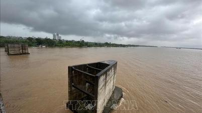
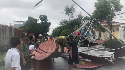
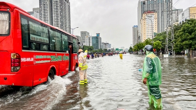
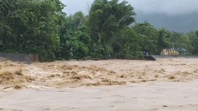
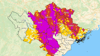
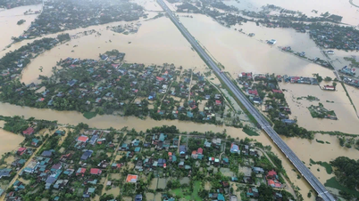
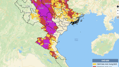
According to the National Center for Hydro-Meteorological Forecasting, the circulation after Storm Bualoi (Storm No. 10) will continue to cause heavy to very heavy rain in the Northern region, including Lao Cai . Prolonged heavy rain can lead to dangerous weather phenomena such as flooding, flash floods, and landslides, especially in mountainous and remote districts.
In September alone, the East Sea was hit by four consecutive storms and a tropical depression, mainly due to the strong activity of the tropical convergence zone under the impact of climate change.
Source: https://baolaocai.vn/bien-dong-lai-sap-don-bao-vao-dau-thang-10-post883267.html

![[Photo] General Secretary To Lam receives US Ambassador to Vietnam Marc Knapper](https://vphoto.vietnam.vn/thumb/1200x675/vietnam/resource/IMAGE/2025/9/29/c8fd0761aa184da7814aee57d87c49b3)

![[Photo] The 1st Congress of Phu Tho Provincial Party Committee, term 2025-2030](https://vphoto.vietnam.vn/thumb/1200x675/vietnam/resource/IMAGE/2025/9/30/1507da06216649bba8a1ce6251816820)
![[Photo] Solemn opening of the 12th Military Party Congress for the 2025-2030 term](https://vphoto.vietnam.vn/thumb/1200x675/vietnam/resource/IMAGE/2025/9/30/2cd383b3130d41a1a4b5ace0d5eb989d)
![[Photo] General Secretary To Lam, Secretary of the Central Military Commission attends the 12th Party Congress of the Army](https://vphoto.vietnam.vn/thumb/1200x675/vietnam/resource/IMAGE/2025/9/30/9b63aaa37ddb472ead84e3870a8ae825)


![[Photo] General Secretary To Lam attends the ceremony to celebrate the 80th anniversary of the post and telecommunications sector and the 66th anniversary of the science and technology sector.](https://vphoto.vietnam.vn/thumb/1200x675/vietnam/resource/IMAGE/2025/9/29/8e86b39b8fe44121a2b14a031f4cef46)


Comment (0)