

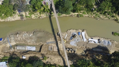
At 8:00 a.m. on September 30, water levels on rivers in Lao Cai province were as follows:
On Thao River at Lao Cai Station 82.97 m, below alarm level 3 is 0.53 m; at Yen Bai Station 34.30 m, above alarm level 3 is 2.30 m.
On Chay River at Bao Yen 83.65 m, flood continues to rise rapidly.
Forecast in the next 6 - 24 hours , on Thao River at Lao Cai Station, flood will continue to decrease, at Yen Bai Station, flood will rise slowly, then decrease; on Chay River at Bao Yen, flood will continue to increase. Peak flood level on Thao River at Yen Bai Station is likely to reach 34.70 m, 2.70 m above alert level 3; peak flood on Chay River at Bao Yen is likely to be at 85.00 m, flood amplitude will increase to 8.0 m, appearing at noon on September 30.

Warning of flood risk and possibility of other natural disasters.
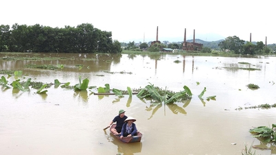
Due to the rising water level of the rivers, flooding will occur in low-lying areas along the rivers. In addition, due to the impact of heavy rain with high intensity, flooding will occur in some communes and wards: Lao Cai ward, Cam Duong ward, Khanh Hoa commune, Luc Yen commune, Muong Lai commune, Phuc Loi commune, Tan Linh commune, Yen Binh commune, Yen Bai ward, Au Lau ward, Nam Cuong ward, Van Phu ward, Tran Yen commune, Xuan Ai commune, Mau A commune, Mo Vang commune, Son Luong commune, Bao Yen commune, Phuc Khanh commune, Bao Ha commune, Quy Mong commune with a flooding depth of 0.5 - 1.00 m, in some places over 2.00 m.
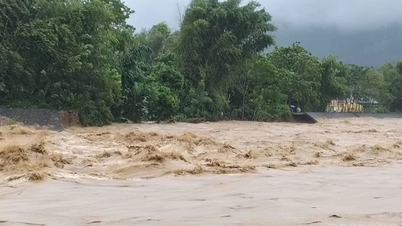
There is a high risk of flash floods and landslides on small rivers and streams, landslides on steep hillsides and road slopes; and land subsidence in areas with poor soil structure in the province (information on areas at risk of flash floods and landslides is detailed to the commune level in separate flash flood and landslide warning bulletins).
Localities with suspension bridges and culverts over small rivers and streams need to warn people to be careful when crossing during times of heavy rain and floods.
Warning level of natural disaster risk due to floods and inundation: Thao River in Lao Cai level 2, Thao River in Yen Bai level 3, Chay River in Bao Yen has no warning level yet.
Flood impact warning: In the next 6-24 hours, flood on Thao River at Lao Cai Station will recede rapidly, on Thao River at Yen Bai Station will continue to rise and then recede rapidly, causing flooding in low-lying areas along the river, riverbank erosion, affecting activities such as waterway traffic, aquaculture, agricultural production, people's lives and socio-economic activities.
Source: https://baolaocai.vn/thong-bao-lu-khan-cap-tren-cac-song-trong-tinh-lao-cai-post883252.html


![[Photo] Prime Minister Pham Minh Chinh meets with representatives of outstanding teachers](https://vphoto.vietnam.vn/thumb/1200x675/vietnam/resource/IMAGE/2025/11/15/1763215934276_dsc-0578-jpg.webp)

![[Photo] Panorama of the 2025 Community Action Awards Final Round](https://vphoto.vietnam.vn/thumb/1200x675/vietnam/resource/IMAGE/2025/11/15/1763206932975_chi-7868-jpg.webp)
![[Photo] General Secretary To Lam receives Vice President of Luxshare-ICT Group (China)](https://vphoto.vietnam.vn/thumb/1200x675/vietnam/resource/IMAGE/2025/11/15/1763211137119_a1-bnd-7809-8939-jpg.webp)


Comment (0)