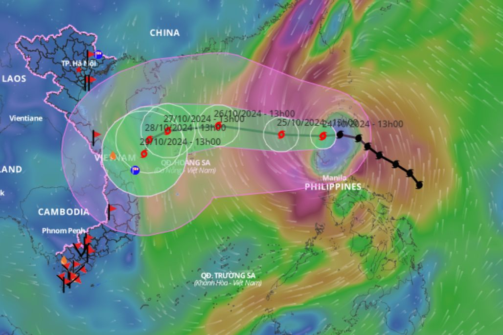
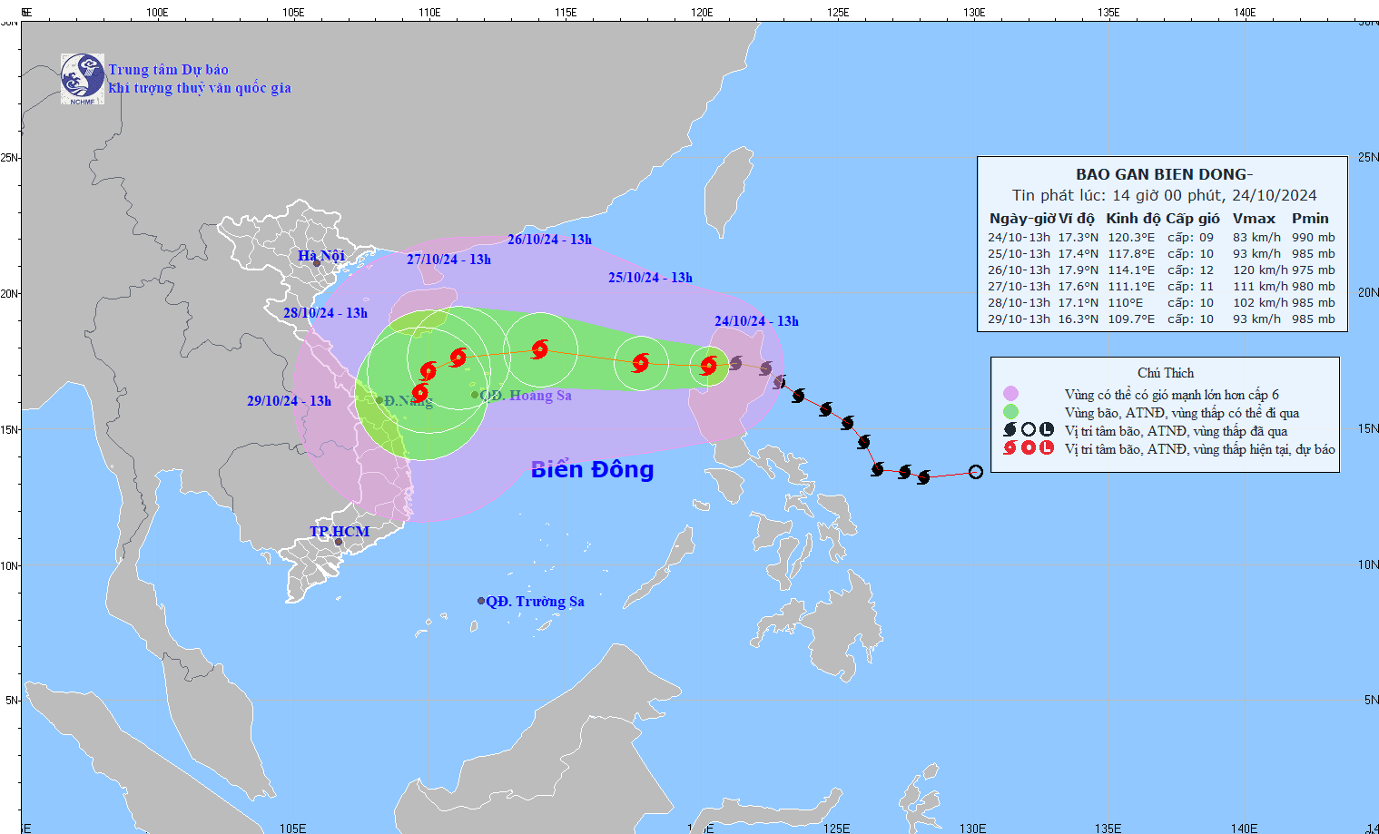
Forecast of the time when Typhoon Tra Mi is at its strongest.
Báo Lao Động•24/10/2024
Typhoon Tra Mi is forecast to reach peak intensity of level 11-12, with gusts up to level 15, when it is located approximately 320km east-northeast of the Hoang Sa archipelago.
Updated location and path of Typhoon Tra Mi at 2 PM on October 24th. Photo: Vietnam Disaster Monitoring System. According to the latest update from the National Center for Meteorological and Hydrological Forecasting, at 13:00 on October 24th, Typhoon Tra Mi was located at approximately 17.3 degrees North latitude and 120.3 degrees East longitude, over land northwest of Luzon Island (Philippines). The strongest winds near the center of the typhoon were at level 9 (75-88 km/h), with gusts up to level 11. The typhoon was moving westward at a speed of 15-20 km/h. Updated location and path of Typhoon Tra Mi at 2 PM on October 24th. Photo: National Center for Meteorological and Hydrological Forecasting.Forecast for the next 24 hours : The storm will move westward at a speed of approximately 10-15 km/h, entering the South China Sea. By 13:00 on October 25th, the storm's center will be located at approximately 17.4 degrees North latitude and 117.8 degrees East longitude, in the eastern part of the North China Sea, 690 km east of the Paracel Islands. The strongest winds near the storm's center will be at force 9-10, with gusts up to force 12. Forecast for the next 48 hours : The storm will move west-northwestward at a speed of approximately 15-20 km/h. By 13:00 on October 26th, the storm's center will be located at approximately 17.9 degrees North latitude and 114.1 degrees East longitude, 320 km east-northeast of the Paracel Islands. The strongest winds near the center of the storm are at force 11-12, with gusts up to force 15. The forecast for the next 72 hours is that the storm will move westward at a speed of approximately 15 km/h. By 13:00 on October 27th, the storm's center will be located at approximately 17.6 degrees North latitude and 111.1 degrees East longitude, over the sea northwest of the Hoang Sa (Paracel) Islands. The strongest winds near the center of the storm will be at force 11, with gusts up to force 13.
Updated location and path of Typhoon Tra Mi at 2 PM on October 24th. Source: Vietnam Disaster Monitoring System.
Over the next 72 to 120 hours , the storm will slow down, moving west-southwest at 5-10 km/h, before potentially changing direction to south-southwest. Regarding the storm's impact, the eastern part of the North East Sea will experience strong winds of force 6-7, later increasing to force 8, reaching force 9-10 (89-102 km/h) near the storm's center, with gusts up to force 12. Sea waves will be 3-5 meters high, and 5-7 meters near the storm's center; the sea will be very rough. Vessels operating in these dangerous areas are likely to be affected by thunderstorms, tornadoes, strong winds, and high waves.

![[Image] National Assembly discusses the implementation of the socio-economic development plan.](https://vphoto.vietnam.vn/thumb/1200x675/vietnam/resource/IMAGE/2026/04/20/1776696707422_ndo_br_img-20260420-185419-jpg.webp)


![[Photo] General Secretary and President To Lam meets with National Assembly delegates from ethnic minorities.](https://vphoto.vietnam.vn/thumb/1200x675/vietnam/resource/IMAGE/2026/04/20/1776696701056_a1-bnd-8331-3342-jpg.webp)


Comment (0)