
Stretching along the azure bay, Ha Long City nestles peacefully against the misty mountain ranges. Amidst this picturesque landscape are tranquil villages and hamlets nestled beside streams and forests. Son Duong commune is one of these highland communes located in such mountain valleys.
Son Duong has a strong minty smell.
There is the Royal Hill, there is the Van Phong Pagoda...
From ancient times, several hundred years ago, before 1925, Son Duong commune had only four villages, each with a communal house: Tien La (Tien Lu), Van Phong, Dong Giang, and Dong Dang. There was an ancient pagoda on the high slopes of the Dia Thau mountain range in Van Phong village. In front of the pagoda was a large stream, commonly called Khe Nganh. Khe Nganh originated from the Da Dun mountain range behind the pagoda. The pagoda in Van Phong village and the surrounding people used water from Khe Nganh, later commonly known as Khe Chua (Pagoda Stream). On the old site of Thuong Pagoda (to distinguish it from its current lower location), there are still quite a few ancient artifacts such as six round stone pillars, approximately 40cm in diameter, a Buddha bathing pool, an incense burner... made of solid green stone. Lung Hung Mo is located in Vuon Cau hamlet, belonging to the Khe Soong branch. It is a small pond, surrounded by mountain rocks like a skylight. Water cascades down from the hillside, overflowing onto large and small, oddly shaped slabs of rock, forming a crystal-clear stream. Today, our group will embark on a "mountain climb" to King Ngu Hill, located northwest of Ha Long City.
The road to King Ngu Hill can be accessed from either Vuon Cau village or Vuon Ram village. It can be reached by 4x4 vehicle or motorbike. The requirement is a skilled driver and familiarity with the route. Speaking of "expert drivers," few can surpass the drivers of acacia wood trucks here. Wherever acacia forests are planted, new "paths and trails" will follow. Seeing the trucks heavily laden with acacia wood crawling along these bumpy, uneven, precarious, and winding roads on steep slopes and rocky terrain, one truly understands the hardship and danger faced by the people in these mountainous regions.
The easiest way is to walk. If you want to challenge yourself, lose weight, and are willing to take a little adventure, then walking is a good option. The paths are already marked out by experienced drivers, so you don't have to worry about getting lost. The estimated time for the round trip to reach (near) the summit is about 3 hours, not including time for rest, recreation, and exploration .
This time, we chose the route from the Areca Garden, passing through several guava orchards in harvest season. To the left of King Ngu Hill, near Dong Lam commune, is a winding road leading to the sacred rock formation. According to the locals, the rock is shaped exactly like the Buddha. The journey was quite arduous, with many steep slopes and rocky sections, but it didn't faze those eager for adventure. Only when we got close to the foot of the mountain, where the trees had parted, did we see the magnificent rock formation. It seemed someone had carved a statue of the Bodhisattva Avalokiteshvara holding a vase of nectar, gazing into the distance towards the west. The mountainside was steep and overgrown with vines, so we could only admire it from afar. Our guide pointed out a rock shaped like a reclining elephant at the foot of the mountain, next to a flat rock resembling a bed.
He recounted: "In the old days, when King Dong Quanh ruled this region, the forest was very dense. The king clasped his hands and prayed towards the mountaintop. Immediately, this huge rock rolled down, making room for the king to rest. That's why the rock is called 'King's Hill.' As for why this mountain is called 'King's Hill,' we only know that it has been called that since ancient times. The locals simply distinguish between mountains: rocky mountains and earthen mountains, which they call 'hills' or 'hills'. Opposite the foot of the Buddha Mountain is a valley with lush green trees, acacia forests, and various shrubs. On the other side of the slope, about 1km away, is a Dao village in Dong Lam commune. There, it's customary for visitors to first drink three cups of wine. If they can't drink, they have to stay for three nights. Therefore, we'll need to plan another trip to prepare ourselves to visit the villages of some friends we already know."
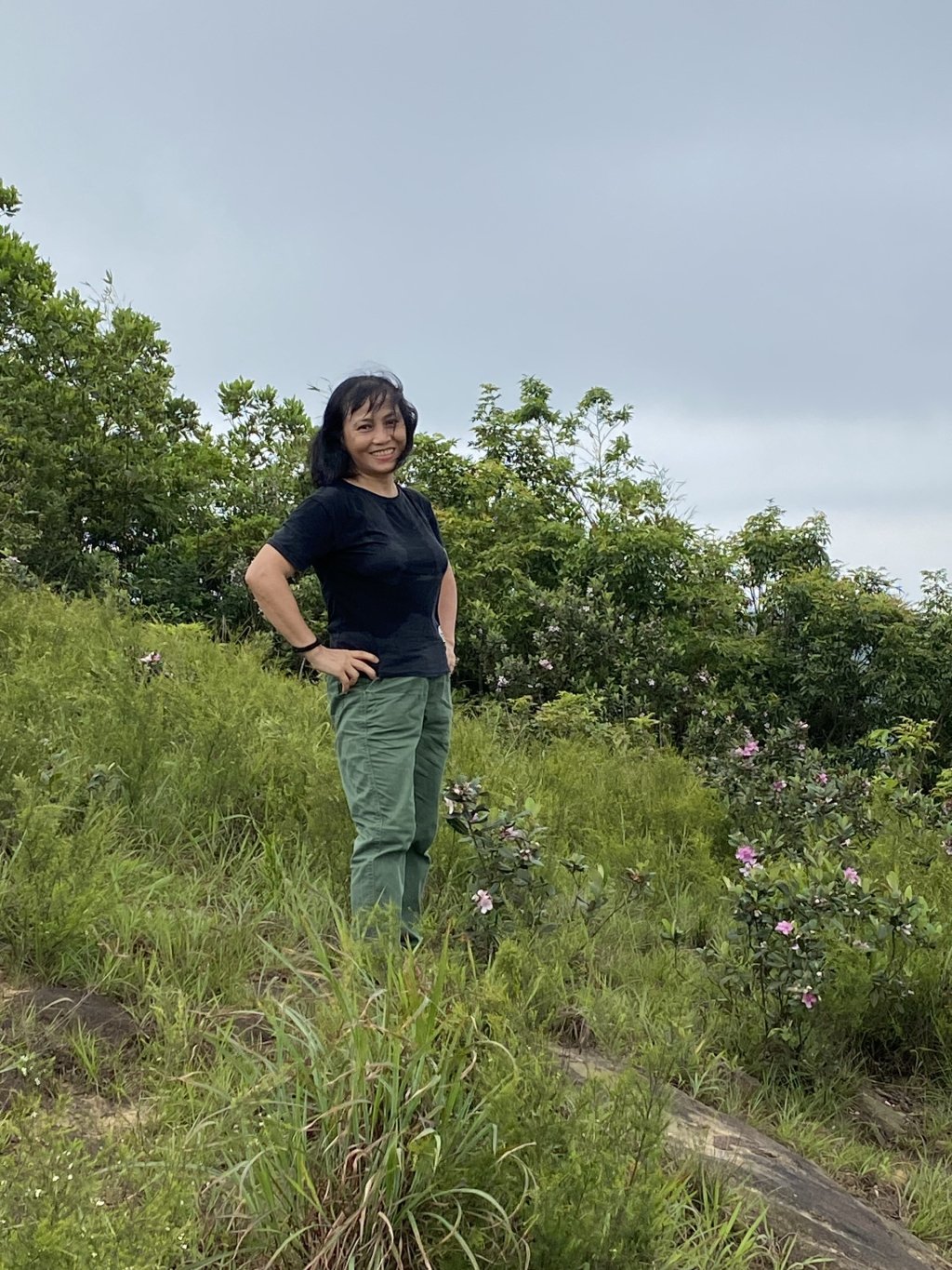
After resting and relaxing for a few minutes on the ancient King's Rock, we continued our journey to the summit of King's Hill. The path from there to the top was more difficult. It was quite steep and slippery with loose rocks. Each of us had to find a walking stick to lean on. It was indeed much easier to walk. In return, the scenery on the left side of the path was truly peaceful. The villages of Vuon Ram, Vuon Cau, Dong Vang... unfolded before our eyes. Golden rice paddies ready for harvest interspersed with guava orchards and patches of acacia trees in vibrant green. Occasionally, a few birds chirped excitedly throughout the forest. Just as the old saying goes, "There are thirty-six kinds of birds in the forest."
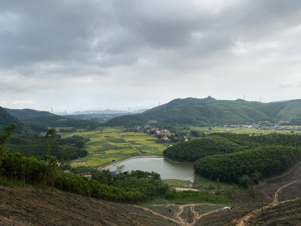
About an hour later, we arrived at our destination. The hillside was clear and breezy. The view was quite open, perfect for admiring Ha Long Bay from above. Although I've been here more than once, each time I still feel overwhelmed and happy amidst the lush green mountains and rolling hills, shrouded in mist. To the southeast lies Ha Long City. The chimneys of cement and thermal power plants, and the high-rise buildings, clearly define the bay's edge. The elegant Bai Chay Bridge spans the Cua Luc Bay, connecting the eastern and western parts of the city. Ha Lung Mountain, Mount Mot, Mount Hai, the Dia Thau mountain range, and the villages of Son Duong stretch out before us. The Hai Phong - Ha Long expressway winds in the distance... To the right are the verdant pine forests, ready for resin extraction. It's a pity we didn't bring hammocks this time so we could have further enjoyed the pure, fragrant natural environment of pine needles and forest trees.
Fortunately, the weather turned cool and shady upon reaching the hillside. This made the scenery even more enchanting and ethereal. This hillside is often the starting point for the Northeast paragliding team. On days with gentle breezes and fine weather, the colorful parachutes, like giant kites, soared serenely across the sky, creating a peaceful and tranquil atmosphere. We took the opportunity to "check in" by the bushes of rhododendron flowers growing beside large rocks on the hillside. The vibrant, wild beauty of these mountain flowers seemed to be reflected in our radiant photographs. I thought to myself: If only there were a smoother, easier road for those who love rustic, unspoiled nature, this route would surely become a noteworthy destination for those who enjoy backpacking. Even families could experience the open space of nature, breathe in the fresh air of the green forest, immerse themselves in the chorus of "thirty-six kinds of birds," and experience firsthand the chirping of various insects. It's also a way for us to slow down, to enjoy, and to cherish the true values of life!
Source

![[Photo] General Secretary To Lam receives President of the European Council Antonio Costa](/_next/image?url=https%3A%2F%2Fvphoto.vietnam.vn%2Fthumb%2F1200x675%2Fvietnam%2Fresource%2FIMAGE%2F2026%2F01%2F29%2F1769697816651_a1-bnd-5216-9741-jpg.webp&w=3840&q=75)


![OCOP during Tet season: [Part 3] Ultra-thin rice paper takes off.](/_next/image?url=https%3A%2F%2Fvphoto.vietnam.vn%2Fthumb%2F402x226%2Fvietnam%2Fresource%2FIMAGE%2F2026%2F01%2F28%2F1769562783429_004-194121_651-081010.jpeg&w=3840&q=75)


![OCOP during Tet season: [Part 2] Hoa Thanh incense village glows red.](/_next/image?url=https%3A%2F%2Fvphoto.vietnam.vn%2Fthumb%2F402x226%2Fvietnam%2Fresource%2FIMAGE%2F2026%2F01%2F27%2F1769480573807_505139049_683408031333867_2820052735775418136_n-180643_808-092229.jpeg&w=3840&q=75)
![OCOP during Tet season: [Part 1] Ba Den custard apples in their 'golden season'](/_next/image?url=https%3A%2F%2Fvphoto.vietnam.vn%2Fthumb%2F402x226%2Fvietnam%2Fresource%2FIMAGE%2F2026%2F01%2F26%2F1769417540049_03-174213_554-154843.jpeg&w=3840&q=75)


Comment (0)