
A major brand offering a "haven" for entrepreneurs.
According to Associate Professor Do Bang of the Thua Thien Hue Historical Society, when Lord Nguyen Hoang and the governor of Quang Nam, Nguyen Phuc Nguyen, wrote many letters calling on foreign merchants to come and trade, the West turned its attention to the East. Japanese and Chinese merchants came to Hoi An and stayed there, building streets and creating a very distinctive urban area, a blend of many cultures.
Lord Nguyen allowed Japanese and Chinese merchants to choose a location near the Hoi An trading port to establish a trading town and permanent residence. From then on, two autonomous districts were formed in Hoi An: one for the Japanese and one for the Chinese. They lived separately, appointed their own officials, and followed the customs and traditions of each country.
At that time in the Quang Nam region, Lord Nguyen also received many Portuguese and Dutch merchant ships for trade and planned to grant the Portuguese 3-4 miles of land near Da Nang port to establish a town with amenities and privileges similar to those Lord Nguyen had granted to the Japanese and Chinese.
Information from an international conference on Hoi An in 1990 revealed that, in the 17th century, the urban landscape of Hoi An was defined as follows: To the east was the Japanese Quarter, located downstream of the river; to the west was the Chinese Quarter, located upstream of the river; to the south was the large river (the Thu Bon River at that time); and to the north was the Vietnamese Quarter (An Nam Quarter).
The Japanese Quarter is located in the site of Hoai Pho village, an ancient village, so the section of the Thu Bon River flowing through Hoi An is also called the Hoai River. The place name Faifo (the name given to Hoi An by the French) also originates from the name of that village and river. Hoai Pho village is recorded in the book O Chau Can Luc (1555). In the 18th century, the village changed its name to Hoa Pho; later it was changed to Son Pho village. Son Pho is currently part of Cam Chau commune, Hoi An city.
According to Dr. Do Bang, the Japanese bought 20 acres of land in Hoai Pho and An My villages to build streets and settle there; they also established a temple named Tung Bon. “In the Pho Da Son Linh Trung Phat stele at Ngu Hanh Son (Da Nang), inscribed in 1640 and which we surveyed and published in 1985, there are nine mentions of the Japanese residence and one mention of the Tung Bon residence, where the Japanese lived in Hoi An and donated a lot of money to this temple. This was the peak period of the Japanese quarter in Hoi An, so Westerners called Hoi An the Japanese city. The first mayor recognized in 1618 was Furamoto Yashiro; there were many mayors with great power in Dang Trong, such as Simonosera. One mayor even intervened with Lord Nguyen to grant special favors to Alexandre de Rhodes during the period when Catholicism was banned,” Associate Professor Dr. Do Bang shared.
Many relics reveal the prosperous life and lifestyle of the Japanese in Hoi An, from markets and seaports to ships and boats, and even the burial practices of the Japanese here: "In 1981, we also found four ancient Japanese tombs in Hoi An, also recording the year of death in the last decade of the 17th century." (According to "Cities of Dang Trong under the Nguyen Lords," Dr. Do Bang)
The Japanese quarter in Hoi An emerged and flourished in the first half of the 17th century and lasted until the end of that century. Due to various embargo policies, the Japanese were forced to return home, while the remaining few married Chinese and Vietnamese people, and the quarter gradually faded away.
In 1618, Chinese merchants began to gather in Hoi An. Besides the horizontal plaque bearing the inscription "Thien Khai - Tan Dau year" (1621) belonging to a Chinese family on Tran Phu Street, which is considered the oldest artifact of the Chinese quarter.
Documents also indicate that during the heyday of the Chinese quarter, the Chinese built an ancestral temple called Cam Ha Palace in 1626, on the border of Cam Pho and Thanh Ha villages, located west of present-day Hoi An city. Numerous documents provide evidence of Chinese immigrants buying land in Hoi An to establish the quarter, as evidenced by land and house purchase deeds on what is now Tran Phu Street.
Tran Phu Street at that time had become a bustling Chinese neighborhood with two rows of houses as Bowyear described (1695): "This harbor has only one main street on the riverbank, with two rows of 100 houses on either side, all inhabited by Chinese people."
Also in 1695, Thich Dai San, upon arriving in Hoi An, recorded in his "Overseas Chronicle" (translated by Hue University, 1963): "Along the riverbank, there is a road 3-4 miles long, called Dai Duong Nhai. The houses on both sides are closely packed. The shop owners are all from Fujian and still dress in the style of the previous dynasty."
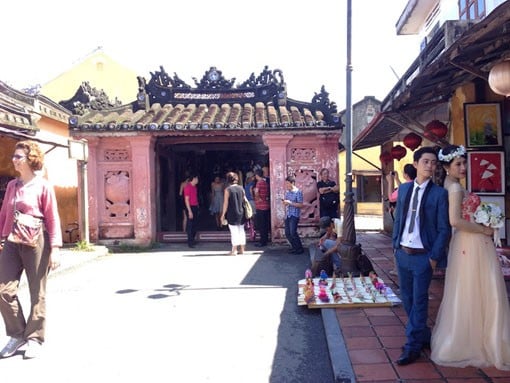
In his article "Hoi An: 400 Years of Legend," researcher Chau Phi Co stated: "The Japanese established their settlements at the sunrise end of the city, while the Chinese built their streets at the sunset end." The connection between the Japanese and the Chinese further enlivened Hoi An's heritage. The Japanese built a bridge called the Japanese Bridge (Lai Vien Bridge), and the Chinese built a temple on it to worship the Northern Emperor, hence the name Cau Temple (Dog Temple). This is a landmark that everyone visiting Hoi An should see.
The map "Thien Nam Tu Chi Lo Do Thu" drawn by Do Ba (1630 - 1655) shows names like Hoi An Street, Hoi An Style, etc., which helps us confirm that Hoi An Street and Hoi An Bridge (Japanese Bridge) were built in the first half of the 17th century.
Heritage sites such as the Hoi An communal house and the Ong Voi temple on Le Loi Street are believed by historians to have been part of a Vietnamese urban area that emerged in the first half of the 17th century, alongside the Chinese and Japanese quarters. Thus, within Hoi An, Japanese, Chinese, and Vietnamese people lived together, creating a diverse and interconnected urban environment, although the customs of each community remained distinct.
Decline due to circumstances and geography.
After a period of prosperity, Hoi An lost its position as a leading trading port in Vietnam. This was partly due to geographical changes and partly due to the Nguyen dynasty's policy of prioritizing Da Nang port.


Comment (0)