

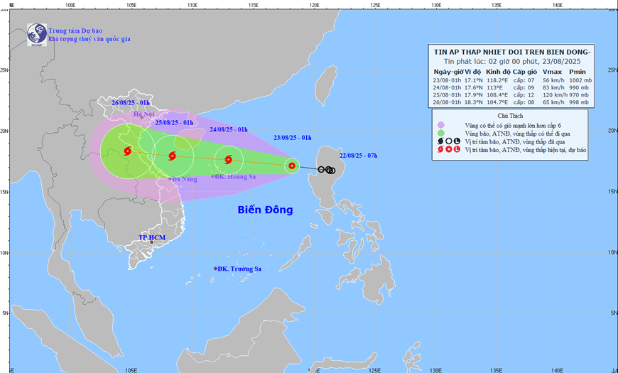
Specifically, early this morning, The tropical depression is at about 17.1 degrees North latitude; 118.2 degrees East longitude, about 730km east of Hoang Sa special zone; strong wind level 7 (50-61km/hour), gust level 9; moving in the West Northwest direction, speed about 25km/hour.
It is forecasted that in the next 48 to 72 hours, the tropical depression will strengthen into a storm, move in the West Northwest direction, travel about 15km per hour and gradually weaken.
It is forecasted that the North East Sea area (including Hoang Sa special zone) will have strong winds of level 6-7, then increasing to level 8, near the storm's eye level 9-10, gusting to level 12; waves 3-5m high, near the storm's eye 4-6m; very rough seas; ships operating in dangerous areas are likely to be affected by storms, whirlwinds, strong winds, and big waves.
Weather forecast for regions across the country today:
Northwest: Cloudy, with moderate rain, heavy rain and thunderstorms in the morning, locally very heavy rain; thunderstorms with the possibility of tornadoes, lightning, hail and strong gusts of wind; temperature 23-30 degrees Celsius.
Northeast: Cloudy, scattered showers and thunderstorms, locally heavy rain; in mountainous areas, cloudy in the morning, moderate rain, heavy rain and thunderstorms, locally very heavy rain; Southeast to South wind level 2-3; in thunderstorms, there is a possibility of tornadoes, lightning, hail and strong gusts of wind; temperature 24-34 degrees Celsius.
Hanoi capital: Cloudy, intermittent sunshine during the day, showers and thunderstorms in some places in the evening and at night; light wind, from early tomorrow morning there will be strong northeast to north winds at level 2-3; in thunderstorms there is a possibility of tornadoes, lightning and strong gusts of wind; temperature 25-34 degrees Celsius.
From Thanh Hoa to Hue: Cloudy, sunny during the day, scattered showers and thunderstorms in the evening; Southeast wind level 2-3; in thunderstorms there is a possibility of tornadoes, lightning, hail and strong gusts of wind; temperature 24-34 degrees Celsius.
South Central Coast region: Cloudy, scattered showers and thunderstorms; scattered showers and thunderstorms in the late afternoon and evening; southwest wind level 2-3; thunderstorms with possibility of tornadoes, lightning, hail and strong gusts of wind; temperature 23-34 degrees Celsius.
Central Highlands region: Cloudy, scattered showers and thunderstorms, scattered showers and thunderstorms in the late afternoon and evening, locally heavy rain; southwest wind level 2-3; thunderstorms with possibility of tornadoes, lightning, hail and strong gusts of wind; temperature 20-31 degrees Celsius.
Southern region: Cloudy, scattered showers and thunderstorms, scattered showers and thunderstorms in the late afternoon and evening, locally heavy rain; southwest wind level 2-3; thunderstorms with possibility of tornadoes, lightning, hail and strong gusts of wind; temperature 23-34 degrees Celsius.
Ho Chi Minh City: Cloudy, scattered showers and thunderstorms, especially in the late afternoon and evening with scattered showers and thunderstorms, locally heavy rain; southwest wind level 2-3; in thunderstorms there is a possibility of tornadoes, lightning, hail and strong gusts of wind; temperature 23-34 degrees Celsius.
Hoang Sa special economic zone (Da Nang): Scattered showers and thunderstorms; in thunderstorms there is a possibility of tornadoes and strong gusts of wind level 6-7; visibility is over 10km, decreasing to 4-10km in the rain; Northwest wind level 4-5; waves 2-3.5m high.
Truong Sa special economic zone (Khanh Hoa): Scattered showers and thunderstorms; in thunderstorms there is a possibility of tornadoes and strong gusts of wind level 6-7; visibility is over 10km, decreasing to 4-10km in the rain; southwest wind level 4-5; waves 1.5-2.5m high.
Source: https://baolangson.vn/thoi-tiet-hom-nay-23-8-ap-thap-nhiet-doi-di-vao-bien-dong-5056871.html


Comment (0)