
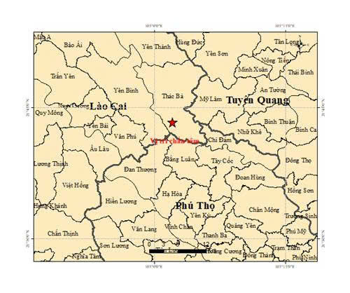
At 4:31:45 PM on April 14, 2026 ( Hanoi time), an earthquake with a magnitude of 3.0 on the Richter scale occurred at coordinates 21.722 degrees North latitude and 105.035 degrees East longitude, with a focal depth of approximately 16.8 km. The earthquake occurred in Thac Ba commune, Lao Cai province.
Earlier that same day, at 2:52:53 AM (Hanoi time) on April 14th, an earthquake with a magnitude of 2.7 on the Richter scale occurred at coordinates 15.030° North latitude – 108.162° East longitude, with a focal depth of approximately 8.1 km. The earthquake occurred in the Mang But commune, Quang Ngai province. The level of natural disaster risk is 0.
The Earthquake Information and Tsunami Warning Center – Institute of Earth Sciences is continuing to monitor this earthquake.
According to geophysics experts, historically, the region with the strongest earthquake intensity has been the Northwest of Northern Vietnam (and it will certainly remain the most vulnerable region in the future).
Regarding earthquakes in the Central Highlands and South Central regions, as well as other areas, no place has recorded earthquakes as strong as the two earthquakes that occurred in the Northwest region so far.
Specifically, the 6.7 magnitude earthquake in Dien Bien City in 1935 and the 6.8 magnitude earthquake in Tuan Giao (Lai Chau) in 1983.
Source: https://cand.com.vn/Xa-hoi/xay-ra-dong-dat-o-xa-thac-ba-lao-cai-i802542/
![[Photo] National Assembly Chairman Tran Thanh Man attends the opening session of IPU-152](https://vphoto.vietnam.vn/thumb/1200x675/vietnam/resource/IMAGE/2026/04/16/1776277863731_ctqh5-jpg.webp)

![[Photo] My Son at night: A thousand-year-old heritage site amidst the Milky Way](https://vphoto.vietnam.vn/thumb/1200x675/vietnam/resource/IMAGE/2026/04/15/1776261039184_ndo_br_chon6-jpg.webp)

![[Photo] Mrs. Ngo Phuong Ly meets and exchanges views with Mrs. Peng Li Yuan](https://vphoto.vietnam.vn/thumb/1200x675/vietnam/resource/IMAGE/2026/04/16/1776277858080_phu-nhan-1-jpg.webp)
![[Photo] The General Secretary, President and his wife meet with Vietnamese-Chinese friendship leaders.](https://vphoto.vietnam.vn/thumb/1200x675/vietnam/resource/IMAGE/2026/04/15/1776264829725_vna-potal-tong-bi-thu-chu-tich-nuoc-to-lam-gap-mat-nhan-sy-huu-nghi-viet-nam-trung-quoc-8703641-3130-jpg.webp)


Comment (0)