
Early morning on June 10th, the low-pressure area over the northern South China Sea strengthened into a tropical depression. The strongest winds near the center of the tropical depression reached level 6 (39-49 km/h), with gusts up to level 8; it is moving slowly westward at a speed of about 5 km/h.
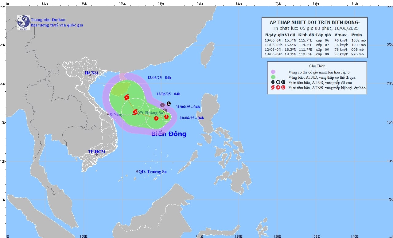
Forecasts indicate that by 4:00 AM on June 11th, the tropical depression will be moving westward at a speed of approximately 5 km/h and is likely to intensify. Its predicted location at this time is approximately 15.5 degrees North latitude; 114.4 degrees East longitude, about 240 km east-southeast of the Hoang Sa (Paracel) Islands. Wind speeds will be at force 6-7, gusting to force 9.
The danger zone in the South China Sea over the next 24 hours (strong winds of level 6 or higher, gusts of level 8 or higher) is located between 13.0 and 18.5 degrees North latitude and between 112.0 and 118.0 degrees East longitude. The level of natural disaster risk due to strong winds at sea is level 3, affecting the northern South China Sea (including the Paracel Islands) and the northern part of the central South China Sea.
By 4:00 AM on June 12th, the tropical depression is likely to strengthen into a typhoon, moving in a west-northwest direction at a speed of 10-15 km/h. Its predicted location at this time is over the Hoang Sa archipelago, approximately 16.3 degrees North latitude; 111.7 degrees East longitude. Wind speeds are expected to be at level 8-9, with gusts up to level 11.
The danger zone over the next 48 hours will expand from 13.5 to 18.5 degrees North latitude and from 109.5 to 117.0 degrees East longitude. The level of natural disaster risk will continue to remain at level 3, affecting the northern South China Sea, the northern part of the central South China Sea, and the offshore waters from Hue to Quang Ngai .
Over the next 48-72 hours, the storm is likely to change direction, moving north-northwest at a speed of approximately 10 km/h and potentially strengthening further.
Forecasts indicate thunderstorms, strong winds of force 6-7, gusting to force 9, in the northern and northern parts of the South China Sea; rough seas with waves 2.0-4.0m high. Vessels in the dangerous area should be aware of the high risk of thunderstorms, tornadoes, strong winds, and high waves.
According to VOV
Source: https://baothanhhoa.vn/ap-thap-nhiet-doi-tren-bien-dong-cach-quan-dao-hoang-sa-khoang-360km-251569.htm


![[Photo] Prime Minister Pham Minh Chinh presides over a meeting on private sector economic development.](/_next/image?url=https%3A%2F%2Fvphoto.vietnam.vn%2Fthumb%2F1200x675%2Fvietnam%2Fresource%2FIMAGE%2F2025%2F12%2F20%2F1766237501876_thiet-ke-chua-co-ten-40-png.webp&w=3840&q=75)


Comment (0)