
Cities along the river
The day we returned from Thai Binh city to the Ba Lat estuary, where the Red River flows into the East Sea, marking the end of its journey through Vietnamese territory, a thunderstorm broke out. In the distance, dark clouds swirled. The Ba Lat estuary opened up into a vast expanse of water, with rows of casuarina trees bending in the sea breeze.

.")
Standing atop the Ba Lat lighthouse, built nearly 30 years ago, I gaze into the distance at the Red River, its reddish-brown alluvial waters blending with the turquoise waters of the East Sea, creating a distinctive blue-red contrast. I felt as if I were seeing this image again at the border river junction in Lao Cai city, where the Red River meets the Nam Thi River. Flowing to the Bach Hac junction, in Phu Tho province, the Red River continues to merge with the Da and Lo rivers, creating another blue-red contrast.


Here, at the Ba Lat estuary, the Red River widens with long stretches of mangrove swamps extending towards the sea. It is in this downstream area of the Red River that Thai Binh province plans to build two new urban areas in Tien Hai district: the Nam Phu new urban area and the Nam Trung new urban area.

On its journey of transformation, Thai Binh province is orienting itself towards building a chain of riverside urban areas, opening up new horizons for socio-economic development. The Nam Phu and Nam Trung urban areas in Tien Hai district are the first building blocks laying the foundation for the province's urban expansion strategy.
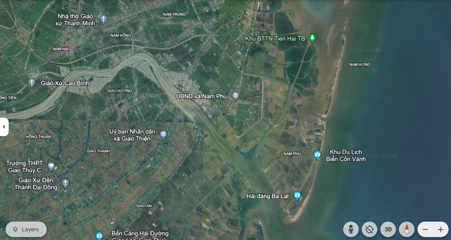

Nam Phu, a gateway urban area in the South, is planned to cover over 2,450 hectares, aiming for the development of ecotourism and the marine economy. A new space will emerge, where green landscapes blend with tourist service areas, seaports, and historical and cultural relics, creating a harmonious picture of tradition and modernity.
Not far from there, the Nam Trung urban area, spanning over 786 hectares, embodies the spirit of a central urban hub in the southern part of Tien Hai district. Open spaces are created, flexibly connecting the administrative center, economic zone, service areas, small-scale industrial production, and modern agriculture. Every road and every building will paint the picture of a dynamic and sustainable urban area.

Not only in Tien Hai, but along the Red River, new urban areas such as Binh Thanh (Kien Xuong district), Vu Tien, Xuan Hoa (Vu Thu district), and Hong Minh (Hung Ha district) are also taking shape. Although currently all are still on paper, in the not-too-distant future, these modern urban areas will reflect on the river, creating a new, vibrant lifestyle while still preserving the inherent poetic and peaceful charm.
Strategic vision and ambition to reach further.
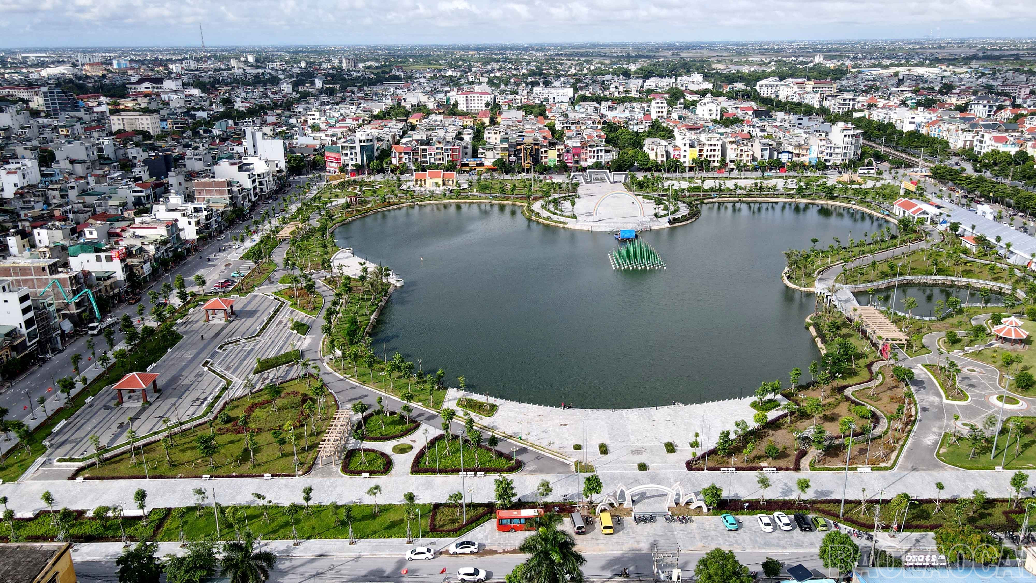
Currently, the urban landscape of Thai Binh province is gradually becoming clearer, with the goal of increasing the urbanization rate in the coming years. According to the plan, urban space will expand; the density of planned urban areas will increase. Along with ecological parks, urban renovation projects, and riverside urban areas, this will create a new, modern appearance while preserving the unique identity of Thai Binh. This change not only opens up opportunities for socio-economic development but also improves the quality of life for residents, optimizes urban infrastructure, attracts investment, and creates momentum for sustainable growth.


.")
Not content with simply expanding urban space on land, Thai Binh is painting a bolder picture with its "land reclamation" strategy, opening up new development opportunities in the heart of the ocean. Marine economic projects, seaports, renewable energy, and coastal ecotourism will create breakthroughs, making Thai Binh a bright spot in the Red River Delta region.
Urban development is not simply about expanding scale, but also about the harmonious integration of nature and people, tradition and modernity. A green, modern, and distinctive central area of Thai Binh province will gradually emerge, becoming the center of industrial, commercial, and service development for the region.
With 3 strategic breakthroughs, 6 key tasks, and 4 pillars of economic growth, the planning of Thai Binh province not only reflects innovative thinking but also the strong aspirations of the Party Committee, government, and people of the province.
The journey of shaping the future
From riverside urban areas to coastal urban development strategies, every step taken by Thai Binh carries the spirit of innovation and sustainable development. The roads opened, the buildings erected, all point towards a common goal: to position Thai Binh among the most developed provinces in the Red River Delta.

In the not-too-distant future, urban areas along the Red River and the Pacific coast will no longer be just sketches on paper. They will become tangible, bustling and vibrant, yet still retaining the charm of the Northern Vietnamese countryside. Streets reflected in the water, tree-lined avenues, and lush green parks will create an ideal living space, where people can immerse themselves in nature amidst a modern lifestyle that remains familiar and welcoming.
Thai Binh is transforming day by day, hour by hour. Today's aspirations will become reality, creating a prosperous land with comprehensive and sustainable development. A bright future awaits, where Thai Binh will not only be the rice granary of the North, but also a modern economic and urban center, an attractive destination on Vietnam's development map.
Final article: Creating new spaces for development
Source: https://baolaocai.vn/bai-6-hanh-trinh-kien-tao-nhung-do-thi-ven-song-post399346.html


![[Photo] Prime Minister Pham Minh Chinh presides over a meeting on private sector economic development.](/_next/image?url=https%3A%2F%2Fvphoto.vietnam.vn%2Fthumb%2F1200x675%2Fvietnam%2Fresource%2FIMAGE%2F2025%2F12%2F20%2F1766237501876_thiet-ke-chua-co-ten-40-png.webp&w=3840&q=75)


Comment (0)