
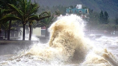
According to the meteorological agency, from morning to noon today, the center of the tropical depression was located over the sea off Quang Ninh province, with maximum wind speeds of level 7 (50-61 km/h), gusting to level 9. Before weakening into a tropical depression, the storm's circulation caused strong winds in several areas, including Bach Long Vi with winds of level 7 gusting to level 8 and waves up to 2 meters high, Quang Ha (Quang Ninh) with winds of level 6 gusting to level 8, Cua Ong (Quang Ninh) with winds of level 6, and many other places recording gusts of level 6.
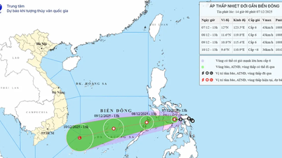
By 13:00, the tropical depression continued to weaken into a low-pressure area with its center at approximately 21.5 degrees North latitude and 107.8 degrees East longitude, with maximum wind speeds below level 6 (below 39 km/h). Forecasts indicate that over the next 12 hours, the low-pressure area will move westward and gradually dissipate.

Although the storm weakened before making landfall and dissipated into a tropical depression, Vietnam's meteorological agency warned that from the afternoon of September 25th to the night of September 26th, the northern region, Thanh Hoa, and Nghe An would experience heavy to very heavy rainfall of 80-180mm, with some areas exceeding 300mm. There is a high risk of urban flooding, flash floods on small rivers and streams, and landslides in hilly areas.
From September 25th to 27th, rivers in Northern Vietnam, Thanh Hoa , and Nghe An are likely to experience flooding. Flood peaks on the Thao, Lo, upper reaches of the Thai Binh River, Hoang Long River, Buoi River, and upper reaches of the Ma River will reach alarm levels 1-2, and in some places exceed alarm level 2.
* Meanwhile, regarding the development of the tropical depression, Dr. Hoang Phuc Lam, Deputy Director of the National Center for Meteorological and Hydrological Forecasting, said that the tropical depression caused strong winds in many areas of Hai Phong, Quang Ninh, Ninh Binh, and Hung Yen. Accordingly, on the morning of September 25, after entering the sea area of Quang Ninh, Typhoon No. 9 weakened into a tropical depression.
Due to the influence of the circulation of typhoon No. 9, strong winds of level 7, gusting to level 8, and waves up to 2m high were recorded in Bach Long Vi special zone (Hai Phong); Quang Ha (Quang Ninh) experienced strong winds of level 6, gusting to level 8; Cua Ong (Quang Ninh) had strong winds of level 6; Mong Cai (Quang Ninh), Phu Lien (Hai Phong), Van Ly (Ninh Binh) and Vu Ninh (Hung Yen) experienced wind gusts of level 6.
At 10:00 AM, the center of the tropical depression was located at approximately 21.5 degrees North latitude and 108.4 degrees East longitude, over the sea off Quang Ninh province. The strongest winds near the center of the tropical depression were at level 7 (50-61 km/h), with gusts up to level 9. It was moving westward at a speed of 15-20 km/h.
Forecasts indicate that by 10 PM on September 25th, the tropical depression over land in the Northeast region will have wind speeds below level 6; moving westward at a speed of approximately 20 km/h, gradually weakening into a low-pressure area. The affected area will be over land in the Northeast region. The level of natural disaster risk is level 3.
Due to the impact of the tropical depression, the northern part of the Gulf of Tonkin (including the Bach Long Vy, Van Don, Co To, Cat Hai special zones and Hon Dau island) will experience strong winds of force 6-7, gusting to force 9, with waves 2-3 meters high; the sea will be rough.
Ships, boats, and aquaculture farms in the aforementioned hazardous zone are all severely affected by strong winds and high waves.
On land, coastal areas from Quang Ninh to Hai Phong will experience strong winds of level 6, with some areas reaching level 7, gusting to levels 8-9; inland areas in the Northeast will experience strong gusts of wind at levels 6-7.
From the afternoon of September 25th to the end of the night of September 26th , heavy rain, and in some places very heavy rain, is expected in the Northern region, Thanh Hoa, and Nghe An provinces. Rainfall amounts will generally range from 80-180mm, with some areas receiving over 300mm. Be prepared for heavy rainfall causing urban flooding.
From September 25th to 27th, a flood is likely to occur on rivers in the Northern region, Thanh Hoa, and Nghe An provinces. Flood peaks on the Thao River, Lo River, upper reaches of the Thai Binh River, Hoang Long River, Buoi River, and upper reaches of the Ma River will reach alarm levels 1-2, with some rivers exceeding alarm level 2.
Heavy rains are likely to cause flooding in low-lying areas; flash floods on small rivers and streams, and landslides on slopes.
Source: https://www.sggp.org.vn/bao-so-9-ragasa-tan-thanh-vung-ap-thap-post814662.html


![[Image] National Assembly discusses the implementation of the socio-economic development plan.](https://vphoto.vietnam.vn/thumb/1200x675/vietnam/resource/IMAGE/2026/04/20/1776696707422_ndo_br_img-20260420-185419-jpg.webp)
![[Photo] General Secretary and President To Lam meets with National Assembly delegates from ethnic minorities.](https://vphoto.vietnam.vn/thumb/1200x675/vietnam/resource/IMAGE/2026/04/20/1776696701056_a1-bnd-8331-3342-jpg.webp)


Comment (0)