
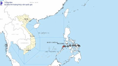
On the morning of December 8, the National Center for Hydro-Meteorological Forecasting informed that the tropical depression had passed through the central Philippines. The center of the tropical depression was located at approximately 11.7 degrees North latitude - 121.5 degrees East longitude, in the western coastal area of the central Philippines. At this time, the tropical depression was at level 6, gusting to level 8 and moving west-southwest at a speed of nearly 15km/hour.

The National Center for Hydro-Meteorological Forecasting forecasts that in the next 24 to 48 hours, the tropical depression will basically move in the West-Southwest direction, at a speed of about 15-20km/hour. By December 9, the tropical depression will be located in the Southeast sea area of the central East Sea, maintaining an intensity of level 6 with gusts of level 8. By the morning of December 10, the center of the tropical depression will be nearly 200km southwest of Song Tu Tay Island. After that, the tropical depression will continue to move in the West-Southwest direction at a speed of 20-25km/hour and gradually weaken into a low pressure area in the South East Sea.
According to Mr. Hoang Phuc Lam, Director of the National Center for Hydro-Meteorological Forecasting, from the morning of December 8, the Southeast sea area between the East Sea and the Northeast of Truong Sa has strong winds of up to 6, gusts of 8, and waves of 2-4m. The meteorological agency recommends that ships not operate in this area.
Source: https://www.sggp.org.vn/ap-thap-nhiet-doi-co-the-suy-yeu-thanh-vung-ap-thap-tren-bien-dong-post827443.html


Comment (0)