
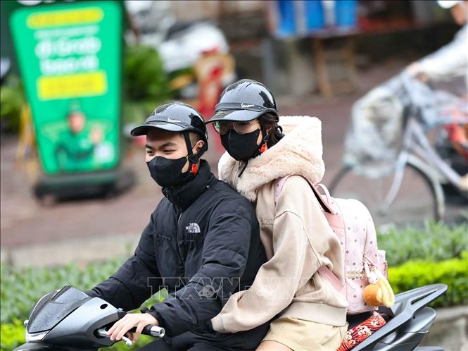
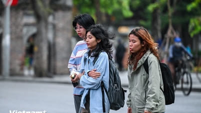
In Hanoi, there will be rain in some places at night and light fog in the early morning; scattered rain and drizzle during the day. Northeast wind level 2-3. Cold at night and morning. Lowest temperature 17-19 degrees Celsius; highest 21-23 degrees Celsius.
In the Northwest region, there will be rain in some places at night and fog in the early morning; during the day, there will be scattered light rain. In the Northwest region, there will be clouds and rain in some places. Light wind. At night and in the morning, it will be cold, with some places being very cold.
Lowest temperature 16-19 degrees Celsius, some places below 15 degrees Celsius; highest 20-23 degrees Celsius, in the Northwest region 23-26 degrees Celsius, some places above 26 degrees Celsius.
In the Northeast, there will be rain in some places at night and fog in the early morning; during the day there will be scattered light rain. Northeast to East wind level 2-3. Cold at night and morning. Lowest temperature 16-19 degrees Celsius, in mountainous areas below 15 degrees Celsius; highest 20-23 degrees Celsius.
In the provinces from Thanh Hoa to Thua Thien Hue, the North has rain in some places at night, localized fog in the early morning, and scattered rain during the day. In the South, there is rain, scattered showers and thunderstorms at night and in some places during the day; there is rain, showers, localized heavy rain and thunderstorms during the day. The North to Northwest wind is level 2-3. In the North, it is cold at night and in the morning, in the South, it is cold. The lowest temperature is 18-21 degrees Celsius; the highest is 22-25 degrees Celsius, in the South, some places are over 25 degrees Celsius.
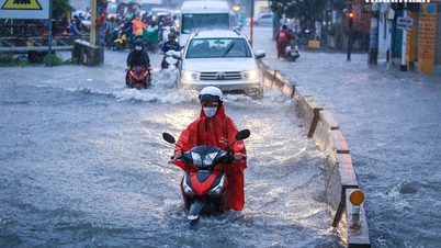
The South Central Coast region is cloudy; the North has scattered showers and thunderstorms, locally heavy rain; the South has scattered showers and thunderstorms. Northeast wind level 3-4. During thunderstorms, there is a possibility of tornadoes, lightning and strong gusts of wind. The lowest temperature is 22-25 degrees Celsius; the highest is 27-30 degrees Celsius, in the South, some places are over 30 degrees Celsius.
In the Central Highlands, there will be showers and thunderstorms in some places. Northeast wind level 2-3. During thunderstorms, beware of tornadoes, lightning and strong gusts of wind. Lowest temperature 17-20 degrees Celsius; highest 25-28 degrees Celsius, some places above 28 degrees Celsius.
The Southern region has scattered showers and thunderstorms. Northeast wind level 2-3. During thunderstorms, there is a risk of tornadoes, lightning and strong gusts of wind. The lowest temperature is 23-25 degrees Celsius, in the East 20-23 degrees Celsius; the highest is 30-33 degrees Celsius.
Ho Chi Minh City has scattered showers and thunderstorms. Northeast wind level 2-3. Risk of tornadoes, lightning and strong gusts of wind during thunderstorms. Lowest temperature 23-25 degrees Celsius; highest 30-33 degrees Celsius.
Weather at sea on the night of December 6 and December 7, the North East Sea (including Hoang Sa) has Northeast wind level 5, especially in the East level 6, sometimes level 7; from tomorrow afternoon gradually increasing to level 6-7, gusting to level 8-9, rough sea. Waves are 3-5m high, later increasing to 4-6m.
In the Central East Sea, the wind will be at level 5, sometimes at level 6; in the West, from tomorrow afternoon, it will gradually increase to level 6, gusting to level 7-8, rough seas. Waves will be 3-5m high. From Khanh Hoa to Ca Mau and the Southwest East Sea (including the West of Truong Sa), the wind will be at level 6, sometimes at level 7, gusting to level 8-9, rough seas. Waves will be 3-5m high.
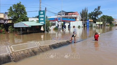
According to the National Center for Hydro-Meteorological Forecasting, from the evening of December 6 to 7, the water level along the Northern coast is at a high level and tends to increase slowly. The highest tide of the day at Hon Dau station is likely to reach 4.1-4.15m, the peak tide time is from 4-7am. It is forecasted that from December 8 to 9, the water level along the Northern coast is at a high level and tends to increase slowly. The highest water level at Hon Dau is forecast to reach 4.15-4.2m.
The National Center for Hydro-Meteorological Forecasting said that this is a high tide period, low-lying areas along the coast, along rivers, and areas outside the dike are likely to be flooded for 4-7 hours every day. High tides will slow down the flood drainage process on the river system in the area. In the evening and at night, it is necessary to be on guard against strong currents flowing offshore when the tide recedes, which is dangerous for maritime activities and sea tourism, especially at ports and beaches.
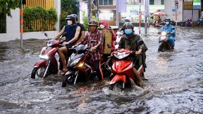
At the same time, it is forecasted that from the evening of December 6 to 7, the highest water level in the eastern coast of the South will tend to decrease slowly, the highest tide peak of the day at Vung Tau station is likely to reach 4.1-4.2m, the peak tide time is from 2-5pm and 11pm-2am. It is forecasted that from December 8 to 9, the highest water level in the eastern coast of the South will tend to decrease slowly, the highest tide peak of the day at Vung Tau station is likely to reach 3.9-4m.
The eastern coastal area of the South needs to pay attention to prevent high risks of flooding and dike overflow in low-lying coastal and riverside areas, outside the dike, affecting traffic, agricultural production, aquaculture, water pollution and people's lives.
Source: https://baotintuc.vn/xa-hoi/thoi-tiet-dem-6-va-ngay-712-mien-bac-troi-ret-suong-mu-mien-nam-mua-dong-cuc-bo-20251206181217587.htm
![[Photo] National Assembly Chairman Tran Thanh Man attends the VinFuture 2025 Award Ceremony](/_next/image?url=https%3A%2F%2Fvphoto.vietnam.vn%2Fthumb%2F1200x675%2Fvietnam%2Fresource%2FIMAGE%2F2025%2F12%2F05%2F1764951162416_2628509768338816493-6995-jpg.webp&w=3840&q=75)


![[Photo] 60th Anniversary of the Founding of the Vietnam Association of Photographic Artists](/_next/image?url=https%3A%2F%2Fvphoto.vietnam.vn%2Fthumb%2F1200x675%2Fvietnam%2Fresource%2FIMAGE%2F2025%2F12%2F05%2F1764935864512_a1-bnd-0841-9740-jpg.webp&w=3840&q=75)


Comment (0)