
Long An and Tay Ninh were once part of Gia Dinh province.
Before becoming two independent provinces as they are today, both Long An and Tay Ninh provinces underwent many changes in their administrative boundaries throughout their history.
According to the history of Long An province, this locality was once an important territory of the Funan-Chenla kingdom. When Nguyen Huu Canh came to explore the South, Long An land belonged to Gia Dinh prefecture.
During the reign of Minh Mạng, Long An province belonged to Gia Định province and part of Định Tường province. At the beginning of the French colonial period, Southern Vietnam was divided into 21 provinces, and Long An province was located within the territories of Tân An and Chợ Lớn provinces.
In 1976, Long An province merged with Kien Tuong province and the two districts of Duc Hoa and Duc Hue from Hau Nghia province to form the new Long An province, which has existed to this day.
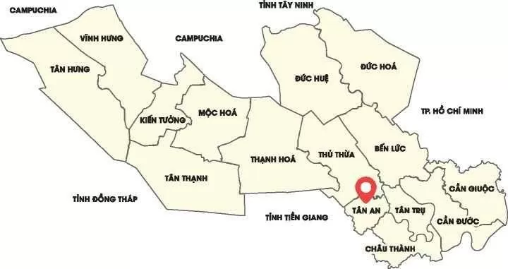
Current administrative map of Long An province.
As for Tay Ninh province, in 1698, during the expedition to the Southern region by Commander-in-Chief Le Thanh Hau Nguyen Huu Canh, Gia Dinh prefecture was established. At that time, the land of Tay Ninh belonged to Tan Binh district, Gia Dinh prefecture, Phan Tran province.
In 1802, King Gia Long (Nguyen Phuc Anh) changed Gia Dinh Prefecture to Gia Dinh Province. In 1832, King Minh Mang changed the province to a provincial, dividing the entire Southern region into six provinces: Phan An, Bien Hoa, Dinh Tuong, Vinh Long, An Giang , and Ha Tien. The Tay Ninh area belonged to Phan An province.
In 1836 (the 17th year of Minh Mạng's reign), Phiên An province was renamed Gia Định province. Tây Ninh prefecture was established under Gia Định province, comprising two districts: Tân Ninh and Quang Hoá.
By 1900, the French Governor-General of Indochina established Tay Ninh province, comprising two districts: Thai Binh and Trang Bang.
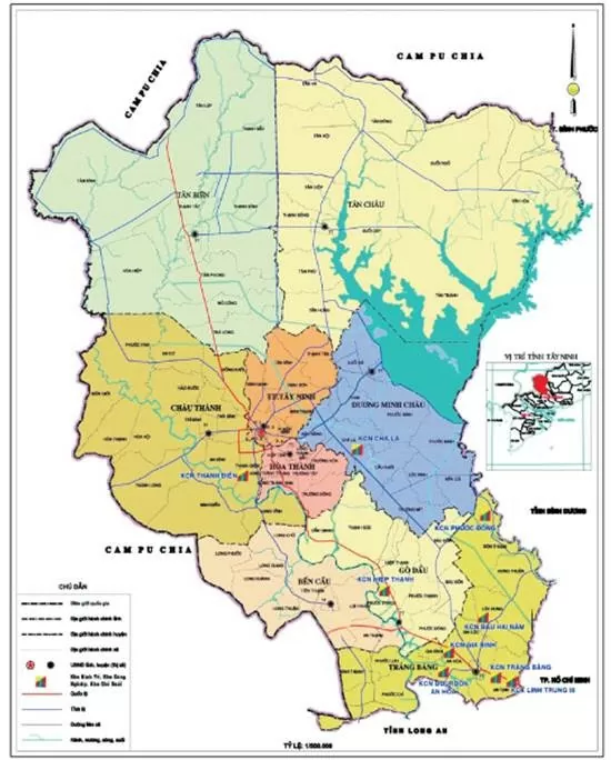
Current administrative map of Tay Ninh province.
In May 1951, the Central Committee of the Southern Region divided the entire South into two Sub-regions: the Western Sub-region and the Eastern Sub-region, and simultaneously merged several provinces. Tay Ninh, along with the two districts of Hoc Mon and Go Vap (Gia Dinh province) and the two districts of Duc Hoa Thanh and Trung Huyen (Cho Lon province), merged to form Gia Dinh Ninh province. Also in that year, Duong Minh Chau district was established within Gia Dinh Ninh province, comprising five communes: Ninh Thanh, Thanh Binh, Chon Ba Den, Dinh Thanh, and Phuoc Ninh.
After 1975, Tay Ninh had 7 districts and 1 town with 73 communes, including: Trang Bang, Go Dau, Ben Cau, Phu Khuong (Toa Thanh), Chau Thanh, Duong Minh Chau, Tan Bien and Tay Ninh town. In 1989, Tan Chau district was established from the land of two districts: Tan Bien and Duong Minh Chau.
Let's prioritize the development of high-tech industries and agriculture.
Over the years, Long An and Tay Ninh have also been "bright spots" in the overall picture of the key economic region of Southern Vietnam. Although not leading the way, both have strategic locations, great economic potential, and strong strides in developing infrastructure, industrial parks, and attracting foreign direct investment (FDI).
Long An province holds a particularly important strategic location, bordering Ho Chi Minh City to the east, Tay Ninh and Cambodia to the north, and Dong Thap and Tien Giang provinces to the west and south. Situated in the transitional zone between the Southeast region and the Mekong Delta, Long An has both favorable conditions for industrial development and strong potential for agricultural growth.
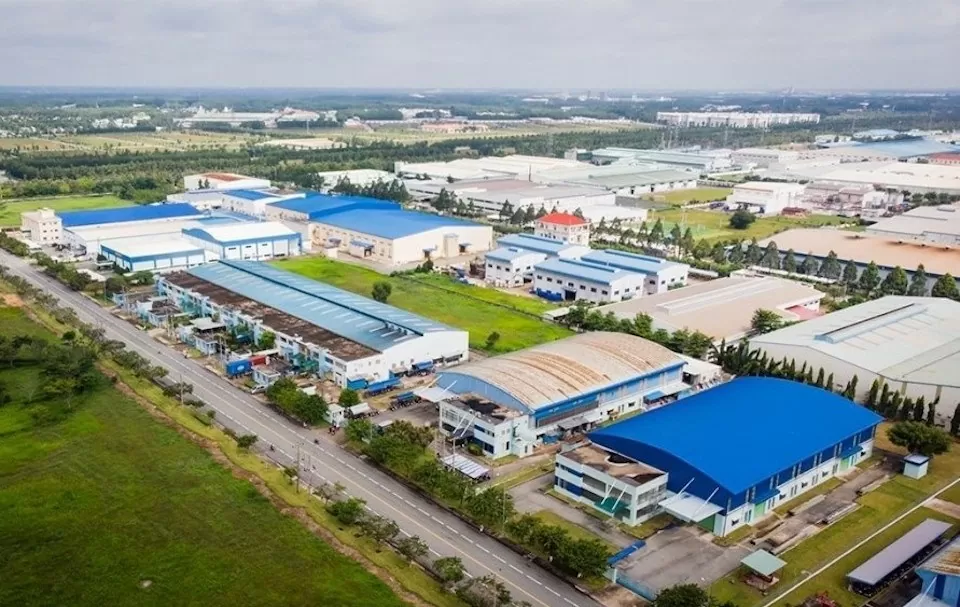
A view of Duc Hoa 3 Industrial Park, Duc Hoa District, Long An Province. Photo: VNA
In its sustainable development orientation, Long An focuses on two key areas: industry and high-tech agriculture. Specifically, the industrial sector will prioritize the development of processing industries, electronic component manufacturing, textiles, and building materials production. As for high-tech agriculture, the province will focus on producing high-quality rice, organic vegetables, and fruits for export.
In addition, in recent years, Long An has focused heavily on investing in transportation infrastructure to promote regional connectivity and attract investment. The road network has developed rapidly with key routes such as National Highway 1A, National Highway 50, National Highway 62, and the Ho Chi Minh City - Trung Luong Expressway.
In addition, the province is stepping up investment in ring roads along with port and logistics expansion projects, helping to optimize the transportation of goods between Long An and Ho Chi Minh City and neighboring provinces.
Similarly, Tay Ninh province, strategically located in the heart of the Southern key economic region, is becoming a bright spot in attracting investment and developing its economy.
Thanks to its advantageous geographical location, synchronized transportation infrastructure, and especially the Moc Bai border gate – one of the most important international border gates in the South – Tay Ninh is rising strongly on the economic map of Vietnam.
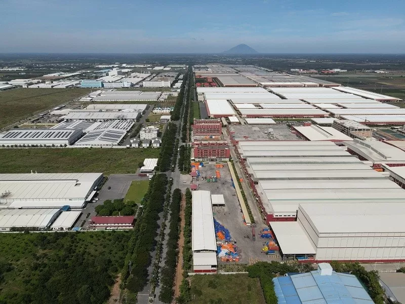
A view of an industrial park in Tay Ninh. Photo: Tay Ninh Newspaper
Recognizing the crucial role of infrastructure in attracting investment, Tay Ninh has been implementing many key transportation projects. Among them, the Ho Chi Minh City – Moc Bai expressway is being accelerated, contributing to connecting the province with major economic centers. National highways 22, 22B, and the ring road are also being upgraded, creating favorable conditions for goods transportation and logistics development.
Furthermore, Tay Ninh and Long An are strengthening their transportation infrastructure connections to promote trade between the two provinces. Routes such as Provincial Roads 822, 823, and 825 play a crucial role in linking Tay Ninh with Duc Hoa and Ben Luc districts of Long An. This facilitates the rapid flow of goods between industrial zones in both localities, creating favorable conditions for businesses to expand production and export activities.
Tay Ninh focuses its development on three main areas: industry, high-tech agriculture, and tourism. Among these, agricultural processing, electronic component manufacturing, textiles, and renewable energy are the key sectors. Meanwhile, high-tech agriculture focuses on export crops such as rubber, high-quality rice, and specialty fruits.
Currently, Long An is one of the localities with the fastest industrial park development rate in the country, with 37 industrial parks and 62 industrial clusters covering a total area of over 15,000 hectares, strongly attracting domestic and foreign investors.
Meanwhile, Tay Ninh has 9 industrial parks and 7 industrial clusters with a total area of over 4,500 hectares, attracting many foreign investors, especially from South Korea, Japan, China and Europe.
Source: Congthuong.vn
Source: https://baotayninh.vn/lich-su-sap-nhap-tinh-cua-long-an-va-tay-ninh-a188330.html


![[Photo] Prime Minister Pham Minh Chinh presides over a meeting on private sector economic development.](/_next/image?url=https%3A%2F%2Fvphoto.vietnam.vn%2Fthumb%2F1200x675%2Fvietnam%2Fresource%2FIMAGE%2F2025%2F12%2F20%2F1766237501876_thiet-ke-chua-co-ten-40-png.webp&w=3840&q=75)


Comment (0)