
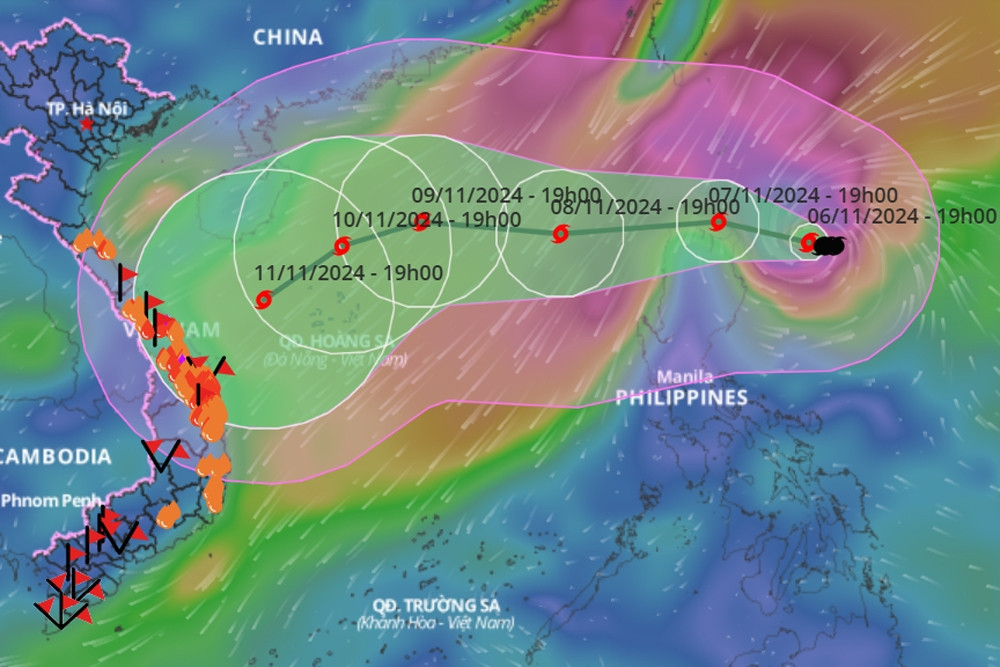
At 7:00 AM on November 7th, the center of Typhoon Yinxing was located in the sea northeast of Luzon Island, with maximum wind speeds of level 15 (167-183 km/h), gusting above level 17. When Typhoon Yinxing enters the South China Sea, it will become the 7th typhoon of 2024.
According to the National Center for Hydro-Meteorological Forecasting, at 7:00 AM on November 7th, the center of Typhoon Yinxing was located at approximately 18.5 degrees North latitude and 123.1 degrees East longitude, in the sea northeast of Luzon Island (Philippines). The strongest winds near the center of the typhoon reached level 15 (167-183 km/h), with gusts exceeding level 17. It was moving in a west-northwest direction at a speed of 5-10 km/h.
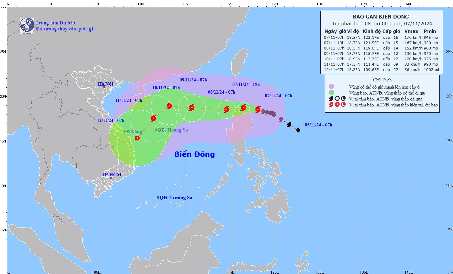
The meteorological agency forecasts the storm's development over the next 24-72 hours as follows:
| Forecast time | Direction, speed | Location | Intensity | Hazardous area | Level of natural disaster risk (Affected area) |
|---|---|---|---|---|---|
| 7am/8/11 | West, at about 15 km/h, entering the South China Sea. | 18.5N-119.6E; East of the North East Sea region | Level 14, then level 16 | Latitude 17.0N-21.0N; East of longitude 118.0E | Level 3: East of the North South China Sea region |
| 7am/9/11 | West-Northwest, 15-20 km/h | 18.7N-115.7E; located east of the North East Sea, 430km east-northeast of the Paracel Islands. | Level 12, then level 14 | Latitude 17.0N-21.0N; East of longitude 114.0E | Level 3: East of the North South China Sea region |
| 7am/10/11 | West-northwest, approximately 10 km/h | 18.9N-113.2E; in the northern South China Sea, 260km north-northeast of the Paracel Islands. | Level 12, then level 14 | Latitude 17.0N-21.0N; Longitude 111.5E-117.5E | Level 3: Northern South China Sea region |
Over the next 72-120 hours, Typhoon Yinxing is likely to change direction, moving southwest at a speed of 10-15 km/h, and its intensity will continue to weaken.
The storm will cause strong winds and high waves at sea: In the eastern part of the North East Sea, winds will be strong at level 6-7. From tonight, this will increase to level 8-10, reaching level 12-14 near the storm's center, with gusts up to level 16; sea waves will be 4-6 meters high, and 6-8 meters near the center; the sea will be extremely rough.
Vessels operating in the aforementioned hazardous areas are susceptible to the effects of thunderstorms, tornadoes, strong winds, and high waves.
The Ministry of Agriculture and Rural Development has issued a directive on responding to Typhoon Yinxing near the East Sea. The Minister of Agriculture and Rural Development requests that ministries, agencies, and the Chairmen of the People's Committees of coastal provinces and cities from Quang Ninh to Binh Thuan:
Firstly, closely monitor the development of the storm; manage vessels at sea; organize the counting of ships and boats; inform owners of vessels and captains of ships and boats operating at sea about the location, direction of movement, and development of the storm so that they can proactively take preventive measures, evacuate, or avoid moving into dangerous areas.
Secondly, the provinces in the central region should urgently and quickly address the consequences of the recent heavy rains and floods.
Inspect measures to ensure the safety of reservoirs and downstream areas; proactively operate reservoirs to ensure flood-receiving capacity as regulated and be prepared to handle any potential situations.
Thirdly, ensure that personnel and resources are ready for rescue and relief operations when required.
Fourth, ministries and agencies, according to their functions and responsibilities in state management and assigned tasks, should proactively direct and coordinate with localities to review plans and prepare forces, means, and resources to ensure safe and effective implementation in response to storms and floods.
Fifthly, Vietnam Television, Vietnam Radio, Vietnam News Agency , the coastal information station system, and mass media agencies from the central to local levels should strengthen measures to inform all levels of government and the public about the developments of the storm and heavy rain so that they can proactively prevent and respond promptly and effectively.
Sixth, maintain a strict 24/7 duty roster and regularly report to the Ministry of Agriculture and Rural Development (through the Department of Dyke Management and Disaster Prevention and Control).
Source: https://vietnamnet.vn/tin-bao-moi-nhat-7-11-bao-yinxing-gan-bien-dong-manh-cap-15-2339593.html


![[Photo] General Secretary and President To Lam and the President of the Philippines hold talks.](https://vphoto.vietnam.vn/thumb/1200x675/vietnam/resource/IMAGE/2026/06/01/1780283481955_vna-potal-tong-bi-thu-chu-tich-nuoc-to-lam-va-tong-thong-philippines-hoi-dam-8797519-1429-jpg.webp)


Comment (0)