
The Mekong Delta, the most distinctive area of Hai Lang district, is not only known as the province's rice granary, but also as a riverine region rich in specialty fish and shrimp. During the dry season, people tilt their fields to collect water from the O Lau River to sow rice. During the flood season, they become fishermen on the vast fields. The people here live harmoniously with nature, utilizing the fertile alluvial soil after each flood to produce plump, milky rice grains.
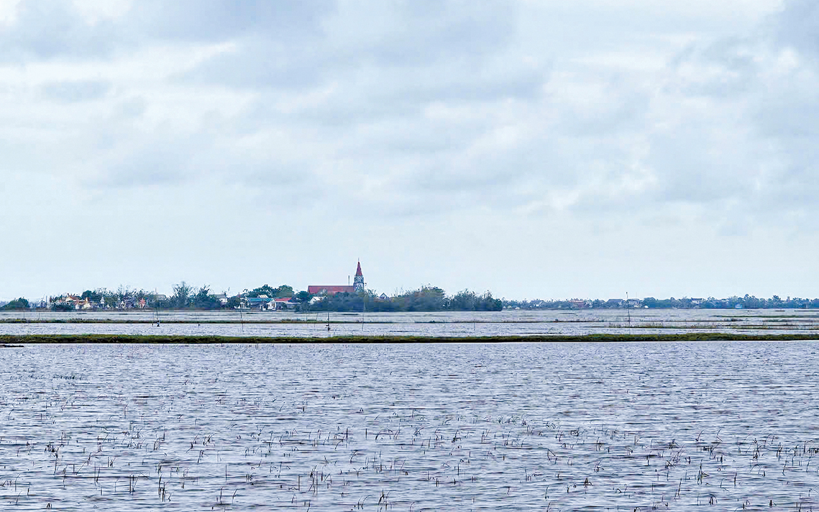
The Hội Điền area is surrounded by vast stretches of water - Photo: MT
I returned to the lowland area of Hai Lang district on an early morning ferry trip down the legendary O Lau River. The dawn breaking on the horizon heralded a sunny day. People came to the riverbank to wash clothes and go about their daily activities, their laughter echoing across the river. In a moment of inspiration, the ferryman steered the boat in a beautiful curve. On the other side, waves lapped against the shore, and the sound of people from Hue, from Phuoc Tich and Ha Vien villages of Phong Hoa and Phong Binh communes in Phong Dien district, rang out: "Who's joking around like that?" The ferryman returned to this side of the river, and I heard the heavy Quang Tri accent of people from Van Quy and Hung Nhon villages of Hai Phong commune, Hai Lang district: "Hey, you're so clever, daring to tease us!" That's how it is, the O Lau River, a crossroads of two distinct cultures, imbued with the rich history of the riverbank and the ferry of yesteryear. The river carries heavy silt, nourishing the rice paddies of the lowland lowland area.
Old memories...
Legend has it that over 500 years ago, during their journey of expanding territory and establishing villages, our ancestors chose the land east of Hai Lang district, where vast rice fields stretched as far as the eye could see, and where the O Lau River originated from the majestic Truong Son Mountains, to develop their production and living spaces. Some people from the communes of Hai Tho, Hai Hoa, Hai Chanh, Hai Tan, and Hai Thanh (Hai Lang) came to the low-lying rice paddies behind the villages, next to the O Lau River, to settle and make a living. These settlements were called "cang." There were a total of seven "cang," including: Cay Da, Hung Nhon, An Tho, My Chanh, Hoi Dien, Cau Nhi, and Trung Don.
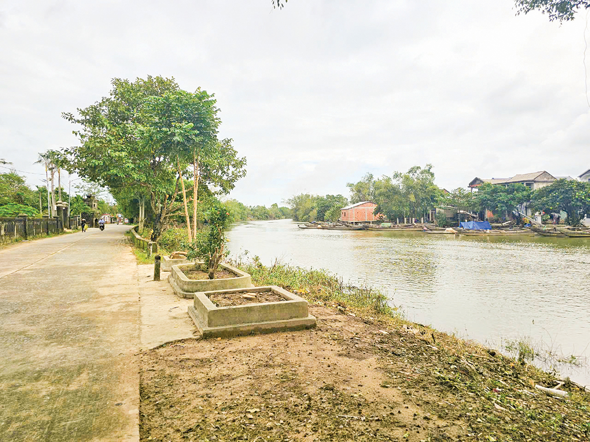
The O Lau River, a place of historical romance, where the cultures of Quang Tri and Thua Thien Hue provinces intersect - Photo: MT
Once, while on a work trip to An Tho port, we saw farmers hastily harvesting their ripening rice and bringing it home to dry. Upon inquiry, we learned that they were harvesting their summer-autumn rice crop to escape the early floods. An elderly farmer with a long white beard shared: “We can only harvest 5 or 6 parts of the crop now. After deducting all expenses, it’s practically a crop failure. But looking at the sky, we know that in about ten days, the early floods will inundate the fields, and then not a single grain of rice will be left. It’s better to harvest while the rice is still green than to let it wither in the field.”
As predicted, just five days later, raging floods swept across the fields, completely submerging thousands of houses and their contents. The basin-shaped terrain of the areas, including Thac Ma, O Lau, O Khe, Tan Vinh Dinh, and Cuu Vinh Dinh, makes them susceptible to flooding from the river. Agricultural production is constantly threatened by natural disasters, particularly the three major flood periods. The minor flood occurs from May 15th to June 15th each year.
This is the harvest season for the winter-spring rice crop and the planting season for the summer-autumn crop. Early floods occur during the winter-spring planting period from December 15th to 31st. Early floods occur during the summer-autumn rice harvest period from August 20th to September 10th. In Hai Lang district, each year during the main flood season, there are 4-5 moderate to minor floods that inundate almost all rice-growing areas, crops, and some residential areas. A common characteristic is that the floods arrive quickly but recede very slowly due to the low-lying terrain and the fact that there is only one drainage direction: Tam Giang Lagoon.
Mr. Tran Ngoc Son, Head of Cay Da Port, Dien Truong Hamlet, Hai Tho Commune, humorously remarked: "People talk about floods in the port area like a drunkard's catchphrase, 'three in, seven out.' Each small flood lasts 2-3 days, while a large flood lasts 4-5 days. But the flooding lasts an additional 3-7 days before subsiding to normal levels."
The people have run out of things to block the river...
In the past, people in the low-lying Hai Lang region often recited the folk song: "Only when there is a high dike will my people stop using sandbags to block the river." It's unclear when exactly, but the practice of using sandbags to reinforce dikes and prevent floods to save the village has become a deeply ingrained custom of the farmers in this low-lying area. And this wish became a reality when, in 2010, the Disaster Risk Management Project of the Ministry of Agriculture and Rural Development, specifically the Flood Control Sub-project for the Hai Lang Low-lying Area, was implemented by the Quang Tri Provincial People's Committee to construct a modern concrete flood control dike with a total cost of over 200 billion VND.
We docked at Hoi Dien port. The boatman deliberately drove along the concrete road connecting the dike and the port, using a pole to measure the water level. He sighed, "The impact of typhoon number 4 has caused the concrete road to be flooded by about 2 meters, and the rice fields are flooded much deeper. It's very dangerous." While people in other ports were cleaning their houses and drying their rice under the blazing sun, here the water was still vast. It really made sense what Mr. Son meant by "going in 3, coming out 7."

A lesson at the remote school - Photo: MT
Hoi Dien hamlet has 42 households with nearly 200 people and 30 students at various levels. During the rainy season, parents transport students by motorboat. Previously, when the dike was made of earth, students would miss school for months during the flood season. Now, with a sturdy dike that also functions as a transportation route, schooling is only interrupted during major floods. Because of this "special" characteristic, Hoi Dien is the only hamlet recognized as equivalent to a village, and the hamlet head enjoys the benefits of a village head; the other six hamlets do not. Of the seven hamlets in Hai Lang district, Hai Phong commune has four: Hoi Dien, An Tho, Hung Nhon, and Cau Nhi.
According to Cai Van Cu, Vice Chairman of the People's Committee of Hai Phong commune: “The total rice area in the commune is 1,132 hectares, of which nearly 100 hectares are in the four low-lying areas. Rice yield reaches 70 quintals/hectare/season. The people of the Hai Lang low-lying area are very grateful to the government for building a sturdy dike system to protect their property and crops, combined with roads to serve the people and for rescue efforts during floods. This is a vital lifeline for the socio-economic development of the seven low-lying areas.”
To prove his point, Mr. Cu borrowed his motorbike and took me to each section of the smooth embankment. Let me add a little more about this vice chairman of the commune. Fifteen years ago, I was working in Hai Hoa commune during a very big flood. At that time, around 3 a.m. on September 4, 2009, Mr. Nguyen Manh, Chairman of the Hai Hoa Commune People's Committee, covered in mud and dirt, woke me up with a hoarse voice: "The Ha Mieu sluice gate has broken due to the extremely strong water flow from upstream..."
Following Mr. Manh, I witnessed a large crowd of people using bamboo, straw, earth, and gabions to repair the broken bridge, but all were swept away by the water. Under the bright electric lights, a tall, shirtless man wearing shorts stood in the middle of the raging floodwater, urging people to form a "human barrier" to reduce the force of the water so they could lower the gabions to repair the broken bridge.
And immediately, dozens of people rushed down to join him. They stood shoulder to shoulder, forming a solid barrier that slowed the raging floodwaters. This man told me, "I know it's life-threatening, and I'll be held responsible if something goes wrong, but there's no other way because behind me are the lives of thousands of people in the low-lying areas, thousands of hectares of unharvested rice fields that are being flooded..." That brave man was Cai Van Cu.
Many concerns remain.
I met with the village chiefs: Tran Ngoc Son of Cay Da village; Cai Van Thoi of An Tho village; and Le Van Linh of Hung Nhon village. They all affirmed the important role of the dike system in the lives of the people in the village.
The dike, resembling a giant dragon, winds along the banks of the O Lau, O Khe, Tan Vinh Dinh, and Cuu Vinh Dinh rivers, stretching from Hai Son commune through low-lying areas to Hai Thanh commune in Hai Lang district. The dike is reinforced on three sides with thick concrete slabs after passing through a layer of durable filter material. The dike's surface is an average of 4 meters wide, reaching 5 meters in some places. The slopes and crests of the dike are designed to remain stable during the main flood season. Sections of the dike that also serve as emergency access roads during the rainy season have spacious vehicle shelters every 500 meters.
Before entering the low-lying area, I spoke with Mr. Duong Viet Hai, Vice Chairman of the Hai Lang District People's Committee, and shared the concerns of the district leaders. Mr. Hai said that the dike system had prevented early and late-season floods, protecting the production areas of 12 low-lying communes in Hai Lang. However, the unusually heavy rains at the end of March and beginning of April 2024 exceeded the flood control capacity of this dike system. After each annual rainy season, the riverbanks are severely eroded, with some sections collapsing right up to the base of the dike, creating cavities. The embankment slopes along the dike, paved with concrete slabs, are cracking. The district is requesting the higher authorities to upgrade the dike system's elevation and the drainage pumping system to ensure flood control and protect crops for approximately 5,000 hectares in the Hai Lang low-lying area.
I called the friendly boatman to arrange for Mr. Cu to take me back to Hai Lang district center by motorbike. It was getting dark, and I'd heard the dike was damaged – wasn't that dangerous? I was worried. "Don't worry," Mr. Cu said, "I have over 20 years of experience as the Vice Chairman of the People's Committee of the commune (previously, Mr. Cu was the Vice Chairman of Hai Hoa commune, now Hai Hoa and Hai Tan have merged to form Hai Phong commune, and he holds that position). This is the road I've used to go to the district for meetings for all these years, so I remember every pebble and every damaged slab. The people here want the government or organizations to sponsor a solar power system along the dike to make travel easier. Initially, we could have a power pole every 50 meters, and if funding continues, we can increase the spacing," Mr. Cu shared.
I agree with the legitimate aspirations of the people in the border area, as well as the passionate and responsible heart of this vice chairman of the commune.
Minh Tuan
Source: https://baoquangtri.vn/tro-lai-vung-cang-190731.htm


![[Photo] The General Secretary, President and his wife lay flowers at the Ho Chi Minh Monument in Manila.](https://vphoto.vietnam.vn/thumb/1200x675/vietnam/resource/IMAGE/2026/05/31/1780219759477_anh-man-hinh-2026-05-31-luc-16-29-07.png)


![[Video] Sunset at Lap An Lagoon – Where the sun sets over the fishing nets](https://vphoto.vietnam.vn/thumb/340x192/vietnam/resource/IMAGE/2026/05/31/1780192137701_beach-landscape-sea-water-nature-grass-745871-pxhere-com.jpeg)


Comment (0)