
Storm news in the East Sea, storm number 2
The tropical depression has strengthened into a storm, the second storm in the East Sea. At 4:00 a.m. on July 5, the center of the storm was at about 20.1 degrees North latitude; 117.4 degrees East longitude. The strongest wind near the center of the storm is level 8 (62-74 km/h), gusting to level 10, moving in a West Northwest direction at a speed of 5-10 km/h.
Forecast in the next 24 hours, storm No. 2 in the northeastern sea of the East Sea, changing direction to the North, speed 5-10km/h and likely to strengthen. The strongest wind near the storm center is level 9-10, gusting to level 12.
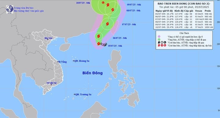
At around 4am on July 7, storm No. 2 in the sea of Fujian province (China) changed direction to North-Northeast, moving about 15km per hour. The strongest wind near the storm's center was level 10-11, gusting to level 13.
At 4:00 a.m. on July 8, storm No. 2 on the mainland along the coast of Zhejiang province (China) moved in a north-northeast direction at a speed of about 15 km/h. The strongest wind near the storm's center was level 10, gusting to level 12.
From the next 72 to 120 hours, the storm moved northwest at a speed of about 5-10km/h and gradually weakened.
Impact of storm No. 2, the northeastern sea area of the North East Sea has stormy rain and strong winds of level 7, the area near the storm's center has levels 8-10, gusts of level 12, very rough seas, waves 3-5m high.
Ships operating in the above mentioned dangerous areas are at risk of being affected by storms, whirlwinds, strong winds and large waves.
Weather forecast for the whole country in the next 10 days
In the next 24-48 hours, the weather in the North will be more stable than in previous days when showers and thunderstorms only appear in a few places. In the Northwest, there will be scattered showers and thunderstorms, but only concentrated in the late afternoon and at night.
Provinces and cities from Thanh Hoa to Hue also have scattered showers and thunderstorms. In the afternoon and at night, the weather is more extreme with scattered showers and thunderstorms, locally heavy rain.
Other areas have scattered showers and thunderstorms. In particular, the northern region of the South Central Coast, the Central Highlands and the South have scattered showers and thunderstorms in the late afternoon and evening, with locally heavy rain.
From the night of July 6 to July 14, the weather in the North will be complicated when heavy to very heavy rains will recur. Accordingly, from the night of July 6 to July 7, the North will have scattered showers and thunderstorms, locally heavy rain. After that, the area will clear up, with localized heat waves. However, from the night of July 9 to July 12, the North will have rain, moderate rain and scattered thunderstorms, locally heavy to very heavy rain.
During the forecast period, provinces and cities from Thanh Hoa to Hue and the South Central Coast will maintain the weather pattern of scattered showers and thunderstorms, concentrated in the late afternoon and night, sunny days, some places will be hot with the highest temperature exceeding 35°C.
The Central Highlands and the South continue to have scattered showers and thunderstorms in the afternoon and evening.
During thunderstorms, beware of extreme weather events such as tornadoes, lightning, hail and strong winds.
Source: https://baolangson.vn/bao-so-2-hinh-thanh-tren-bien-dong-mien-bac-nuoc-ta-sap-mua-lon-tro-lai-5052239.html


![[OCOP REVIEW] Bay Quyen sticky rice cake: A hometown specialty that has reached new heights thanks to its brand reputation](https://vphoto.vietnam.vn/thumb/402x226/vietnam/resource/IMAGE/2025/7/3/1a7e35c028bf46199ee1ec6b3ba0069e)


Comment (0)