
At 7:00 p.m. on September 16, the center of the tropical depression was in the sea east of Luzon Island (Philippines). The strongest wind was level 7 (50-61 km/h), gusting to level 9, up one level compared to 6 hours ago.
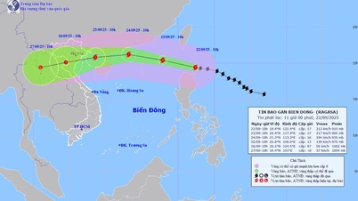
The National Center for Hydro-Meteorological Forecasting said that by 7 p.m. on September 17, the tropical depression moved into the East Sea and strengthened into a storm. Winds near the storm's center were at level 8, gusting to level 10; moving west at a speed of about 25km.
The following evening, the storm was about 150km east-southeast of the Paracel Islands. The strongest wind near the storm's eye was level 8, gusting to level 10; moving west-southwest at a speed of about 15-20km/h.
In the next 48 to 72 hours, the storm is likely to change direction, moving West Northwest, traveling 10-15km per hour and is likely to strengthen.
From the morning of September 17, the eastern sea area of the North East Sea has strong winds of level 6-7, gusts of level 10 (89-102km/h), and rough seas.
The eastern sea area of the North East Sea has waves 2-4m high, increasing to 3-5m from the afternoon of September 16. Ships operating in the above-mentioned dangerous areas are likely to be affected by strong winds and large waves.
From the afternoon of September 16 to September 18, the Central Highlands and the South will have moderate rain, heavy rain and thunderstorms, locally very heavy rain with common rainfall of 40-80mm, locally over 150mm (rain concentrated in the afternoon and night).
On September 17, the Northern and Central regions will have scattered showers and thunderstorms, locally heavy to very heavy rain with rainfall from 15 to 30mm, locally over 90mm (rain concentrated in the late afternoon and night).
Thunderstorms may produce tornadoes, lightning and strong gusts of wind.
Warning: On the night of September 18 and the day of September 19, the Central Highlands and the South will continue to have moderate to heavy rain and scattered thunderstorms, with some places having very heavy rain with common rainfall of 20-40mm, and some places over 90mm.
From September 20, heavy rain in the Central Highlands and the South tends to decrease.
Heavy rain and localized heavy rain are likely to cause flooding in low-lying areas; flash floods in small rivers and streams, and landslides on steep slopes.

Weather forecast for September 17 in regions across the country:
– Hanoi : Scattered showers and thunderstorms, locally heavy to very heavy rain (rain concentrated in the evening, night and morning), light wind. During thunderstorms there is a possibility of tornadoes, lightning and strong gusts of wind. Lowest temperature 25-27 degrees Celsius. Highest temperature 31-33 degrees Celsius.
– Northwest: In the evening and at night, there will be scattered showers and thunderstorms, with some places having heavy to very heavy rain; during the day, there will be showers and thunderstorms in some places, with light winds. During thunderstorms, there is a possibility of tornadoes, lightning and strong gusts of wind. The lowest temperature is 23-26 degrees Celsius, in some places below 22 degrees Celsius. The highest temperature is 29-32 degrees Celsius, in some places above 32 degrees Celsius.
– Northeast: In the evening and at night, there will be scattered showers and thunderstorms, with some places having heavy to very heavy rain; during the day, there will be showers and thunderstorms in some places, with light winds. During thunderstorms, there is a possibility of tornadoes, lightning and strong gusts of wind.
Lowest temperature 24-27 degrees Celsius, mountainous areas below 24 degrees Celsius. Highest temperature 30-33 degrees Celsius.
– Thanh Hoa – Thua Thien Hue: In the afternoon, there will be scattered showers and thunderstorms, with some places experiencing heavy to very heavy rain, light winds. During thunderstorms, there is a possibility of tornadoes, lightning and strong gusts of wind. Lowest temperature 24-27 degrees Celsius. Highest temperature 30-33 degrees Celsius.
– Da Nang to Binh Thuan: In the afternoon, there will be scattered showers and thunderstorms, locally heavy to very heavy rain, southwest wind level 2-3. During thunderstorms, there is a possibility of tornadoes, lightning and strong gusts of wind. Lowest temperature 24-27 degrees Celsius. Highest temperature 30-33 degrees Celsius.
– Central Highlands: Moderate to heavy rain and scattered thunderstorms, locally very heavy rain (rain concentrated in the afternoon and night), westerly to southwest winds level 3. During thunderstorms, there is a possibility of tornadoes, lightning and strong gusts of wind. Lowest temperature 20-23 degrees Celsius. Highest temperature 26-29 degrees Celsius, some places above 29 degrees Celsius.
– Southern region: Moderate to heavy rain and scattered thunderstorms, locally very heavy rain (rain concentrated in the afternoon and night), southwest wind level 3. During thunderstorms, there is a possibility of tornadoes, lightning and strong gusts of wind. Lowest temperature 24-27 degrees Celsius. Highest temperature 29-32 degrees Celsius, some places above 32 degrees Celsius.
Dantri.com.vn
Source: https://dantri.com.vn/xa-hoi/bien-dong-kha-nang-don-bao-so-4-toi-179-20240916210229555.htm


![[Photo] General Secretary To Lam presents the First Class Labor Medal to the Vietnam National Energy and Industry Group](https://vphoto.vietnam.vn/thumb/1200x675/vietnam/resource/IMAGE/2025/9/21/0ad2d50e1c274a55a3736500c5f262e5)


![[Photo] General Secretary To Lam attends the 50th anniversary of the founding of the Vietnam National Industry and Energy Group](https://vphoto.vietnam.vn/thumb/1200x675/vietnam/resource/IMAGE/2025/9/21/bb0920727d8f437887016d196b350dbf)


Comment (0)