
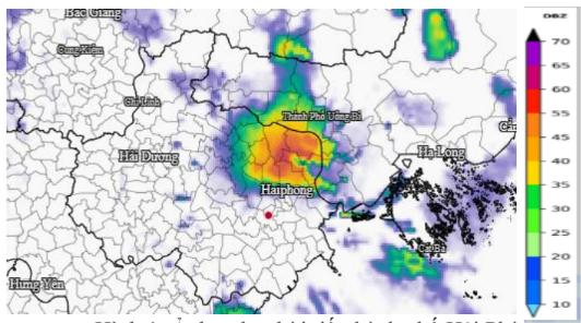
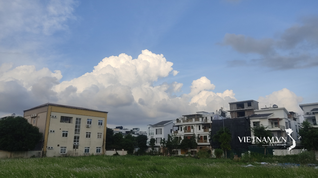
This is the information in the forecast bulletin of Hai Phong Hydrometeorological Station at 3:00 p.m.
Accordingly, thunderstorms in Quang Ninh province are moving towards Hai Phong city. From 3 p.m. to the next few hours, the convective clouds above are likely to develop and expand, causing showers and thunderstorms in the communes and wards in the western and southern areas of Hai Phong city. These are the following localities: Mao Dien, Cam Giang, Cam Giang, Tue Tinh, Viet Hoa, Thach Khoi, Gia Loc, Ke Sat, Binh Giang, Duong An, Thuong Hong, Gia Loc, Yet Kieu, Gia Phuc, Truong Tan, Bac Thanh Mien, Nam Thanh Mien, Binh Giang, Nguyen Luong Bang, Vinh Hai, Vinh Am, Vinh Bao, Nguyen Binh
Khiem, Vinh Hoa, Chan Hung, Hung Thang, Tan Minh, Tien Minh, Vinh Hoa, Vinh Thinh, Vinh Thuan, Tien Lang, Nguyen Giap. After that, it is likely to continue spreading and cause showers and thunderstorms.
neighboring communes and wards.
During thunderstorms, be on guard against tornadoes, lightning and strong gusts of wind that can break trees, damage houses, traffic works and infrastructure, endangering human lives, and endangering farming activities and ships at sea.
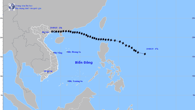
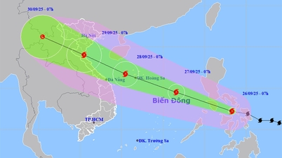
Tropical depression has the potential to become a storm
The National Center for Hydro-Meteorological Forecasting said that at 1 p.m. today, the tropical depression in the sea east of Luzon Island, Philippines, had the strongest wind speed of 61 km/h, level 6-7, gusting to level 9 and was moving northwest at a speed of about 15 km/h.
In the next 24 hours, the tropical depression is likely to strengthen into a storm. By 1 p.m. tomorrow, the storm in the northeastern sea of Luzon Island, at level 8, gusting up two levels, will maintain its direction and move into the East Sea, becoming the 8th storm this year.
At 1 p.m. on September 18, the storm was in the northern East Sea, with the strongest wind at level 8, gusting to level 10, and changing direction to the west-northwest at a speed of 15-20 km/h.
At the same time, a low pressure area is active in the middle of the East Sea. The meteorological agency said that today and tonight this cyclone will strengthen into a tropical depression, but it is unlikely to become a storm.
The Japan Meteorological Agency said that after strengthening into a storm, the tropical depression will move close to mainland Hong Kong, but will not make landfall but change direction along the coast to the Hainan island area.
Due to the influence of the tropical depression, the northeastern sea area of the North East Sea has winds gradually increasing to level 6, gusting to level 8; near the storm center, winds are strong at level 7-8, gusting to level 10, waves are 2.5-4.5 m high. Ships operating in these dangerous areas are likely to be affected by storms, whirlwinds, strong winds, and large waves.
Source: https://baohaiphong.vn/canh-bao-mua-dong-loc-set-o-hai-phong-520956.html


![[Photo] Prime Minister Pham Minh Chinh receives Secretary of Shandong Provincial Party Committee (China) Lin Yu](https://vphoto.vietnam.vn/thumb/1200x675/vietnam/resource/IMAGE/2025/9/26/821396f0570549d39f33cb93b2e1eaee)


Comment (0)