
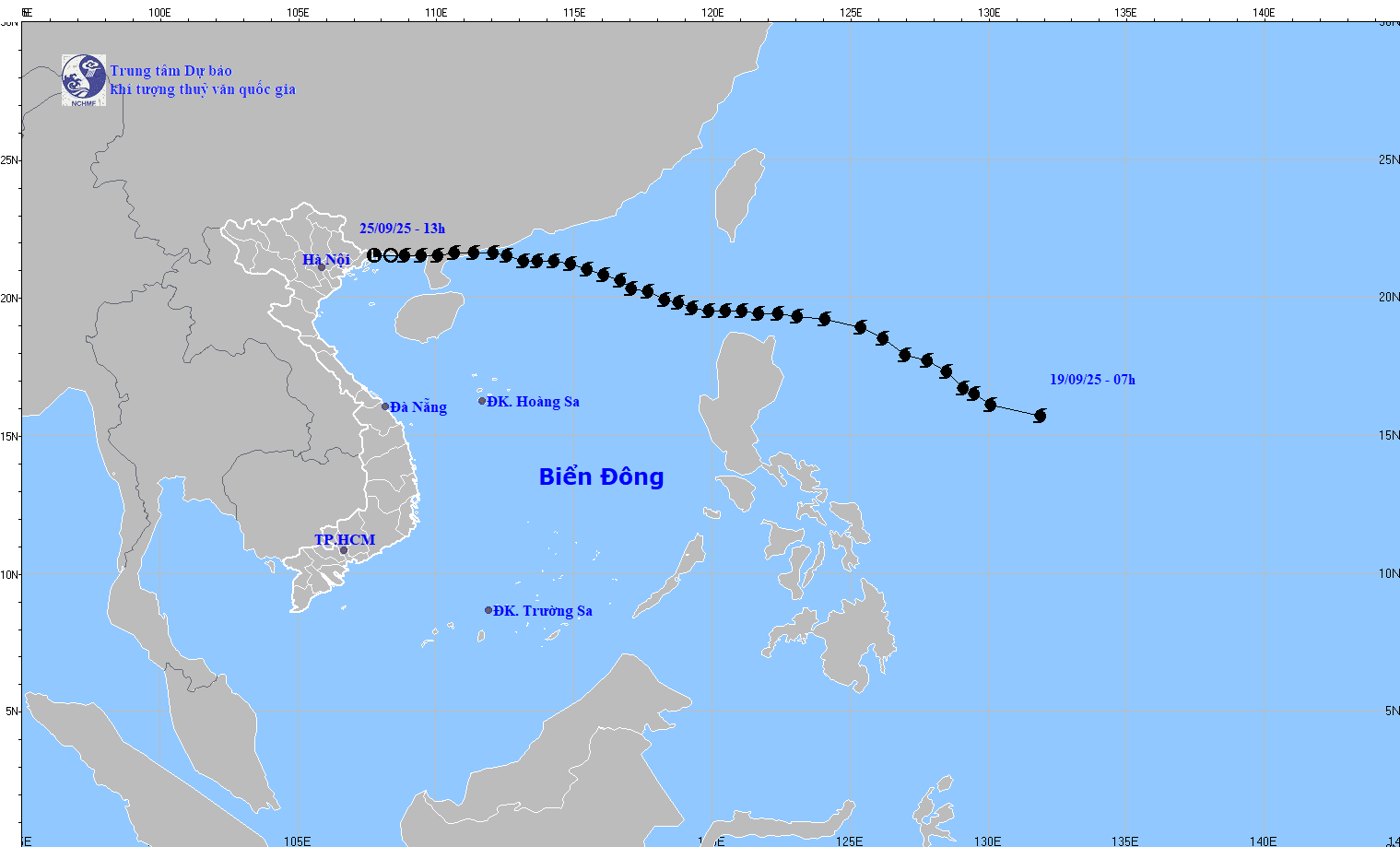
At 13:00 on September 25th, the low-pressure area was located at approximately 21.5 degrees North latitude and 107.8 degrees East longitude. The strongest winds at the center of the low-pressure area were below level 6 (below 39 km/h).
Regarding information about Typhoon Bualoi, Dr. Hoang Phuc Lam, Deputy Director of the National Center for Meteorological and Hydrological Forecasting, said that around the night of September 26th, Typhoon Bualoi will enter the eastern part of the central South China Sea, becoming the 10th typhoon of 2025.
Accordingly, at 13:00 on September 25th, the typhoon's center was located at approximately 11.1 degrees North latitude and 128.1 degrees East longitude, in the sea east of the Philippines. The strongest winds near the center of the typhoon reached level 12 (118-133 km/h), with gusts up to level 15. It was moving in a west-northwest direction at a speed of 15-20 km/h.
At 13:00 on September 26th, the typhoon's center was located at approximately 13.1 degrees North latitude and 123.2 degrees East longitude, with wind speeds of level 12, gusting to level 15; moving in a west-northwest direction at a speed of about 20 km/h.
As of 13:00 on September 27th, the storm was located at approximately 14.8 degrees North latitude and 117.5 degrees East longitude, with wind speeds of level 12, gusting to level 15; moving west-northwest into the East Sea at a speed of about 25 km/h. The affected area is the eastern part of the northern and central East Sea. The level of natural disaster risk is level 3.
As of 13:00 on September 28th, the storm was located at approximately 16.4 degrees North latitude and 111 degrees East longitude, with wind speeds of level 2-13, gusting to level 16; moving in a West-Northwest direction at a speed of about 25 km/h and likely to intensify. The affected area is the northern and central parts of the South China Sea (including the Hoang Sa Special Administrative Region). The level of natural disaster risk is level 3.
Over the next 72 to 120 hours, the storm continued to move rapidly northwest, traveling approximately 25 km per hour.
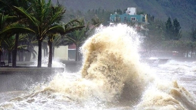
Due to the impact of the storm, from the evening of September 26th, the eastern sea area of the northern and central parts of the South China Sea experienced strong winds of force 6-7, later increasing to force 8-9, with winds near the storm's center reaching force 10-12, gusting to force 15, and sea waves exceeding 5-7 meters in height, resulting in extremely rough seas.
Vessels operating in the aforementioned hazardous areas are susceptible to the effects of thunderstorms, tornadoes, strong winds, and high waves.
Source: https://baotintuc.vn/van-de-quan-tam/tin-cuoi-cung-ve-con-bao-so-9-20250925145625080.htm
![[Photo] Admire the coral "masterpiece" amidst the million-year-old heritage of Dak Lak province.](https://vphoto.vietnam.vn/thumb/1200x675/vietnam/resource/IMAGE/2026/05/31/1780221235105_anh-man-hinh-2026-05-31-luc-16-53-27.png)
![[Image] Hanoi Police officially crowned champions of V-League 2025/2026](https://vphoto.vietnam.vn/thumb/1200x675/vietnam/resource/IMAGE/2026/05/31/1780244769054_ndo_br_039d561b692be875b13a-jpg.webp)
![[Photo] Solemn bathing ceremony and Buddha procession in Hue](https://vphoto.vietnam.vn/thumb/1200x675/vietnam/resource/IMAGE/2026/05/31/1780228263543_1-jpg.webp)


![[Photo] The General Secretary, President and his wife begin their state visit to the Philippines.](https://vphoto.vietnam.vn/thumb/1200x675/vietnam/resource/IMAGE/2026/05/31/1780230559452_anh-man-hinh-2026-05-31-luc-19-28-11.png)


![[Video] Sunset at Lap An Lagoon – Where the sun sets over the fishing nets](https://vphoto.vietnam.vn/thumb/340x192/vietnam/resource/IMAGE/2026/05/31/1780192137701_beach-landscape-sea-water-nature-grass-745871-pxhere-com.jpeg)


Comment (0)