
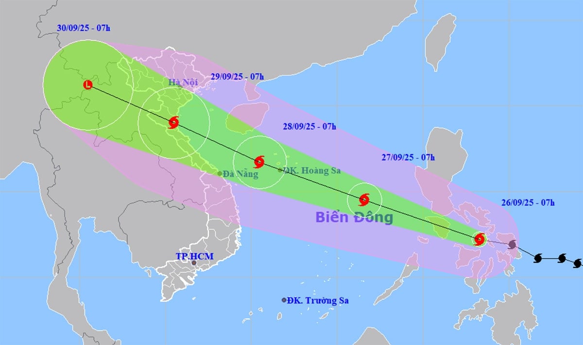
According to the National Center for Hydro-Meteorological Forecasting, at 9:00 a.m. on September 26, the center of storm Bualoi was located in the central region of the Philippines, with intensity of level 11, gusting to level 14.
Around tonight, September 26, storm Bualoi will enter the eastern sea area of the central East Sea, becoming storm number 10 in 2025.
After entering the East Sea, storm No. 10 Bualoi moved in a West-Northwest direction at a very fast speed, averaging 30km/h, twice as fast as normal storms. Around September 28, storm No. 10 Bualoi headed towards the western sea area of Hoang Sa with an intensity that could reach level 13, gusting to level 15.
Storm No. 10 Bualoi is forecast to change direction, moving along the coast towards the North Central provinces and the southern part of the Northern Delta, with direct impact from the storm around September 29.
From September 28-30, the North, Thanh Hoa - Hue will experience very heavy rain.
Also according to the meteorological agency, last night and this morning (September 26), the Northeast had rain, moderate rain, locally heavy to very heavy rain; Ha Tinh to Da Nang , the Central Highlands and the South had scattered showers and thunderstorms, some places had heavy to very heavy rain.
Rainfall from 7pm on September 25 to 8am on September 26 was over 90mm in some places such as: Quat Dong station (Quang Ninh) 217.4mm; Huong Trach station ( Ha Tinh ) 98.6mm; Huong Hoa station (Quang Tri) 143.4mm; Quan Tuong Dai station (Hue city) 186.2mm...
It is forecasted that from the morning of September 26 to the morning of September 27, the Northeast, southern Phu Tho and Thanh Hoa will continue to have moderate rain, heavy rain and thunderstorms, locally very heavy rain, with rainfall ranging from 30 - 70 mm, with some places experiencing over 150 mm. From the afternoon of September 27, heavy rain in these areas will gradually decrease.
Hai Phong area: According to the city's Hydrometeorological Station, through monitoring radar images at 11:00 a.m. today, September 26, convective clouds continue to cause showers and thunderstorms in Cat Hai special zone, Hung Thang ward, Kien Hai, Kien Hung, Nghi Duong.
It is forecasted that in the current period to the next few hours, convective clouds will continue to develop and cause showers and thunderstorms for the above areas, then to the communes/wards in the Southeast of the city: An Bien, Hai An, Kien An, Phu Lien, Hung Dao, Duong Kinh, An Hung, An Khanh, An Quang, An Truong, An Lao, Kien Thuy, Kien Minh, Kien Hai, Kien Hung, Nghi Duong, Quyet Thang, Tien Lang, Tan Minh, Tien Minh, Chan Hung, Hung Thang, Vinh Bao, Nguyen Binh Khiem, Vinh Am, Vinh Hai, Vinh Hoa, Vinh Thinh, Vinh Thuan.
During thunderstorms, be on guard against tornadoes, lightning and strong gusts of wind that can break trees, damage houses, traffic works and infrastructure, endangering human lives.
PVSource: https://baohaiphong.vn/bao-bualoi-di-chuyen-nhanh-gap-doi-bao-binh-thuong-bac-va-trung-bo-sap-mua-lon-521841.html


![[Photo] Prime Minister Pham Minh Chinh receives Secretary of Shandong Provincial Party Committee (China) Lin Yu](https://vphoto.vietnam.vn/thumb/1200x675/vietnam/resource/IMAGE/2025/9/26/821396f0570549d39f33cb93b2e1eaee)


Comment (0)