
At 10:00 AM on October 26th, the typhoon's center was located at approximately 17.1 degrees North latitude and 112.8 degrees East longitude, in the sea northeast of the Hoang Sa archipelago, about 510km east-northeast of Da Nang . The strongest winds near the center of the typhoon reached level 11 (103-117 km/h), with gusts up to level 14.
Latest update on Typhoon No. 6: Approximately 510km east-northeast of Da Nang.
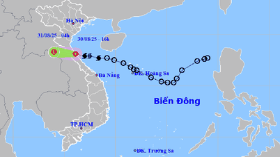
According to the National Center for Meteorological and Hydrological Forecasting: At 10:00 AM on October 26th, the typhoon's center was located at approximately 17.1 degrees North latitude and 112.8 degrees East longitude, in the sea northeast of the Hoang Sa archipelago, about 510km east-northeast of Da Nang.
The strongest winds near the center of the storm are at level 11 (103-117 km/h), with gusts up to level 14. It is moving in a west-southwest direction at a speed of approximately 20 km/h.
Forecast of storm developments (next 24 to 72 hours):

The trajectory of Typhoon No. 6. Photo: nchmf.
Warning about the impact of Typhoon No. 6
Over the next 72 to 120 hours, the storm will move mainly eastward at a speed of 5-10 km per hour, and its intensity will continue to weaken.
At sea:
In the western part of the North East Sea, winds are strong, reaching levels 8-9, and near the center of the storm, levels 10-11 (89-117 km/h), with gusts up to level 14. Sea waves are 5.0-7.0m high, and 7.0-9.0m near the center of the storm; the sea is extremely rough.
The sea areas off the provinces from Quang Binh to Quang Ngai (including Con Co Island, Cu Lao Cham Island, and Ly Son Island) will experience strong winds of force 6-7, later increasing to force 8-9, reaching force 10-11 in areas near the storm's center, with gusts up to force 14; sea waves will be 3.0-5.0m high, and 5.0-7.0m near the storm's center; the sea will be extremely rough.
Storm surge in coastal areas: From the morning of October 27th, coastal areas of provinces from Quang Binh to Quang Nam are likely to experience storm surge of 0.4-0.6m.
- Vessels operating in the aforementioned hazardous areas (especially in the Hoang Sa archipelago area) and the coastal waters from Quang Binh to Quang Ngai are all susceptible to thunderstorms, tornadoes, strong winds, and large waves.
- There is a high risk of erosion of dikes and seawalls along the coast of provinces from Quang Tri to Quang Nam due to the impact of large waves and storm surges.
On land:
From the morning of October 27th, strong winds gradually increased to level 6-7 on the coastal mainland from Quang Binh to Quang Ngai, reaching level 8-9 near the storm's center, with gusts up to level 11.
From the evening and night of October 26th to the night of October 28th, the area from Quang Binh to Quang Ngai will experience heavy to very heavy rain with total rainfall generally ranging from 300-500mm, and in some localized areas exceeding 700mm. A warning is issued regarding the risk of localized heavy rainfall (>100mm/3h). The areas of Ha Tinh, Binh Dinh, and the Northern Central Highlands will experience heavy rain, with some localized areas experiencing very heavy rain, with total rainfall generally ranging from 100-200mm, and in some places exceeding 300mm.
The development of Typhoon No. 6 remains very complex and subject to change. Please note the updates in subsequent typhoon bulletins.
Source: https://danviet.vn/cap-nhat-tin-bao-so-6-moi-nhat-con-cach-da-nang-510km-van-dat-cap-11-giat-cap-14-20241026114310945.htm


![[Photo] Prime Minister Pham Minh Chinh receives the Chinese Ambassador to Vietnam](https://vphoto.vietnam.vn/thumb/1200x675/vietnam/resource/IMAGE/2026/04/05/1775397481797_ndo_br_dsc-5512-jpg.webp)


![[INFOGRAPHICS] Exploiting children's personal images for profit can result in fines of up to 50 million VND.](https://vphoto.vietnam.vn/thumb/402x226/vietnam/resource/IMAGE/2026/04/06/1775442200854_1775442148.webp)


Comment (0)