
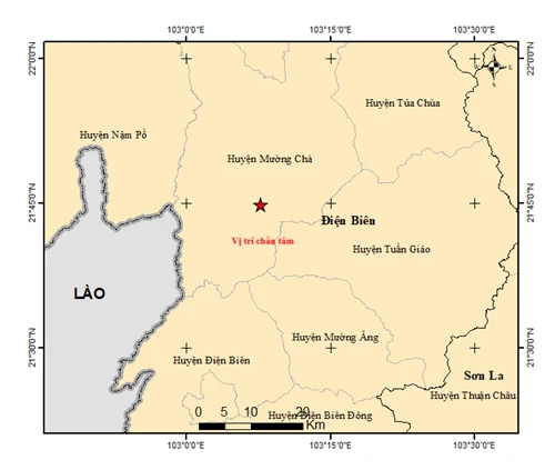
Regarding the 5.0 magnitude earthquake that recently occurred in Muong Cha district, Dien Bien province, Mr. Nguyen Thai Son, Head of the Dien Bien Phu City Seismic Observation Station, Dien Bien province ( thuộc Institute of Earth Sciences ), stated that this earthquake has a corresponding natural disaster risk level of 2.
Immediately after the earthquake occurred, the Dien Bien Phu City Seismic Observatory sent seismic data to the Institute of Earth Sciences.
According to Mr. Nguyen Thai Son, the earthquake was relatively strong, so in the epicenter area, houses built to a certain standard (level 4) with weak walls may show noticeable cracks.
In the Dien Bien Phu city area (about 45km from the epicenter), residents still clearly felt strong tremors, but damage to infrastructure was unlikely.
In the last 100 years, the two largest earthquakes in Vietnam have both occurred in Dien Bien. In 1935, a 6.9 magnitude earthquake struck the southern part of the Dien Bien basin, and in 1983, a 6.7 magnitude earthquake struck Tuan Giao district. Fortunately, neither earthquake caused significant damage because at that time there were not many modern buildings; the area was mostly mountainous.
In the future, earthquakes may occur and cause significant consequences, especially in densely populated areas with critical infrastructure. Therefore, earthquake hazard assessment is essential and needs to be updated annually to practically serve socio -economic development planning and earthquake-resistant design for all types of structures, from critical infrastructure to residential areas.
The Institute of Earth Sciences will continue to survey, observe, and conduct detailed research on the tectonic geology and seismic regime in Dien Bien province and surrounding areas; and promptly inform the authorities and people in the area about earthquake activity.
PV (compiled)Source: https://baohaiduong.vn/dong-dat-manh-5-do-tai-dien-bien-411691.html


![OCOP during Tet season: [Article 4] Elevating local products](/_next/image?url=https%3A%2F%2Fvphoto.vietnam.vn%2Fthumb%2F402x226%2Fvietnam%2Fresource%2FIMAGE%2F2026%2F01%2F29%2F1769652810578_2935-z6982071462129_649e82db06fb2f2ea701388b1f5f5b0b-173322_176-185229-202804_457.jpeg&w=3840&q=75)


![OCOP during Tet season: [Part 3] Ultra-thin rice paper takes off.](/_next/image?url=https%3A%2F%2Fvphoto.vietnam.vn%2Fthumb%2F402x226%2Fvietnam%2Fresource%2FIMAGE%2F2026%2F01%2F28%2F1769562783429_004-194121_651-081010.jpeg&w=3840&q=75)

![OCOP during Tet season: [Part 2] Hoa Thanh incense village glows red.](/_next/image?url=https%3A%2F%2Fvphoto.vietnam.vn%2Fthumb%2F402x226%2Fvietnam%2Fresource%2FIMAGE%2F2026%2F01%2F27%2F1769480573807_505139049_683408031333867_2820052735775418136_n-180643_808-092229.jpeg&w=3840&q=75)


Comment (0)