Vietnam.vn - Nền tảng quảng bá Việt Nam

Dong Thap seeks solutions to address landslides along the Thuong Thoi Tien embankment.

On August 13th, the People's Committee of Thuong Phuoc commune (Dong Thap province) announced that it is coordinating with relevant agencies to urgently address the landslide at the Thuong Thoi Tien embankment, which has disrupted traffic on the Ngo Quyen embankment road (from Gia Bao Company to the Muong Mieu river ferry terminal).

Báo Sài Gòn Giải phóngBáo Sài Gòn Giải phóng13/08/2025

SAT LO THUONG PHUOC7.png
Authorities are currently working to repair the landslide at the Thuong Thoi Tien embankment.

For the time being, the authorities are temporarily reinforcing the area with sandbags, while coordinating with the Southern Institute of Water Resources Science to survey and propose a long-term solution.

Mr. Le Hung Cuong, Vice Chairman of the People's Committee of Thuong Phuoc commune, said that due to the ongoing flood season, the water level of the Tien River is rising and the current is strong, thus increasing the risk of landslides. The authorities have strictly prohibited water and land vehicles from approaching the area until further notice.

SAT LO THUONG PHUOC4.png
Approximately 55 meters of the embankment have collapsed, with the base eroded and creating numerous "cavities."
You may also like
Gia Lai: National Highway 25 deeply flooded, cutting off vital transportation route.
Gia Lai: National Highway 25 deeply flooded, cutting off vital transportation route.On the morning of November 19th, Mr. Nay Quyen, Secretary of the Party Committee of Uar commune (Gia Lai province), stated that National Highway 25, the section passing through Phum hamlet (Uar commune), is deeply flooded, causing traffic disruption on the Gia Lai – Dak Lak route.
Overcoming difficulties to keep supply lines open and protect the seawall.
Overcoming difficulties to keep supply lines open and protect the seawall.The severe flooding in recent days has caused landslides along embankments, disrupted transportation, and threatened the lives and property of people in many localities in Da Nang City and Quang Ngai Province. Faced with this danger, the military and civilians have once again stood shoulder to shoulder, working day and night to reinforce sea embankments, clear roads, and transport food and supplies to isolated villages. The image of soldiers, barefoot and with steely resolve, braving the rain and floods to protect the people has been deeply etched in the hearts of the flood-affected residents.
Details of 5 TOD (Transit-Oriented Development) zones along Metro Line 2 in Ho Chi Minh City with approved planning boundaries.
Details of 5 TOD (Transit-Oriented Development) zones along Metro Line 2 in Ho Chi Minh City with approved planning boundaries.The Ho Chi Minh City People's Committee has just issued a decision approving the planning boundaries for TOD (Transit-Oriented Development) areas around the stations of Metro Line 2 (Ben Thanh - Tham Luong section), with 5 planned areas totaling hundreds of hectares.

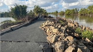
Earlier, on the afternoon of August 12th, a section of the Thuong Thoi Tien embankment collapsed, approximately 55 meters long, damaging the entire slope, causing the sidewalk and railing to subside over a 30-meter stretch, 8 meters wide, and extending 1.5 meters into the asphalt road. The base of the embankment was eroded, creating numerous "cavities," posing a serious risk of further landslides. Prior to that, on August 7th, a similar landslide occurred at the same location, approximately 40 meters long, damaging the embankment and causing cracks in the road surface.

SAT LO THUONG PHUOC2.png
The embankment collapse caused damage to the entire slope, subsidence of the sidewalk and embankment railings.

The Steering Committee for Climate Change Response - Disaster Prevention and Search and Rescue of the commune has sealed off the area, installed warning lights, prohibited vehicle traffic, and established a response team.

The Thuong Thoi Tien embankment is a component of the "Management and Mitigation of Drought and Flood Risks in the Greater Mekong Subregion" project, spanning over 4km with a total budget of hundreds of billions of VND, completed in three phases from 2017 to 2019.

You may also like
Traffic was partially disrupted due to the collapse of dozens of meters along the inter-communal road.
Traffic was partially disrupted due to the collapse of dozens of meters along the inter-communal road.On April 10th, sources from the People's Committee of Cai Nuoc commune, Ca Mau province, reported that a serious road collapse had occurred in the area, causing a section of asphalt road several tens of meters long to completely sink, disrupting traffic in the region. Local authorities have urgently implemented warning barriers and reported the incident to the Provincial People's Committee to find solutions for remediation.
Khanh Hoa: Landslide at Khanh Son Pass cuts off many roads.
Khanh Hoa: Landslide at Khanh Son Pass cuts off many roads.On the evening of November 16th, the Khanh Hoa Provincial Traffic Works Maintenance Management Board announced that heavy rain had caused landslides in several locations on the Khanh Son pass, part of Provincial Road 9.
The Lo Xo Pass has suffered serious landslides, with many sections completely cut off.
The Lo Xo Pass has suffered serious landslides, with many sections completely cut off.Over the past two days, serious landslides have occurred on the Ho Chi Minh Highway, specifically the section through Lo Xo Pass, at the border between Dak Plo commune (Quang Ngai province) and Da Nang city.

Source: https://www.sggp.org.vn/dong-thap-tim-giai-phap-khac-phuc-sat-lo-ke-thuong-thoi-tien-post808109.html

Trending by Category

Most Read

Google Trends

Same author

Heritage

Figure

Enterprise

News

Political System

Destination

Product

Happy Vietnam
SPRING DATE

SPRING DATE

THE HA NHI PEOPLE TODAY

THE HA NHI PEOPLE TODAY

Go to the market

Go to the market