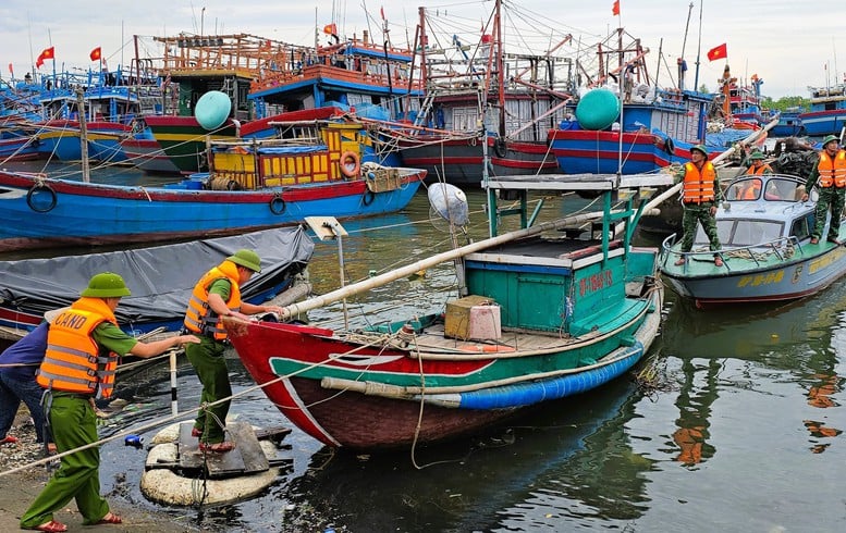
Units are directed to be on duty 24/7, regularly monitoring the developments of storm No. 10 to guide ships to avoid entering dangerous areas.
Briefly reporting on the traffic situation during the time affected by storm No. 10 (storm Buoloi), the Civil Defense Command of the Ministry of Construction said that to ensure safety in the maritime sector, today (September 28), two working groups were organized to inspect the areas: Quang Ninh, Hai Phong, Hung Yen, Ninh Binh on September 27, 2025, the areas: Thanh Hoa, Nghe An, Ha Tinh, Quang Binh, Quang Tri , Thua Thien Hue, Quang Ngai.
Resolutely request ships and boats to move to safe shelters
Units are directed to be on duty 24/7, regularly monitoring the developments of storm No. 10 to guide ships and boats to avoid entering dangerous areas; coordinate with local Civil Defense Commands to have appropriate response measures, resolutely requesting ships and transport boats to move to safe shelters or proactively move out of dangerous areas.
Regular counting is required to strictly manage ships entering and leaving the port.
Port enterprises, shipbuilding and repair factories, construction units, and ship captains in the management areas of responsible port authorities are implementing response work for storm No. 10, which is likely to make landfall in the area.
"As of 7:00 a.m. on September 28, in the management areas of the Maritime Port Authorities: Quang Ninh, Hai Phong, Thai Binh , Thanh Hoa, Nghe An, Ha Tinh, Quang Tri, Thua Thien Hue, Da Nang, Quang Ngai and 2 Inland Waterway Port Authorities of Region I and Region II, there were 652 vessels. Of which, there were 259 seagoing ships and 393 inland waterway vehicles with VR-SB level.
All these vessels have been provided with information about storm No. 10 in the East Sea by maritime port authorities, inland waterway port authorities, and the Vietnam Coastal Information Station system to have appropriate disaster prevention and control plans," the report stated.
More than 100 flights affected by storm
Regarding the aviation sector, the report said that the Civil Aviation Authority of Vietnam has directed the issuance of aviation news notices to temporarily stop receiving aircraft at four airports.
Specifically, Dong Hoi Airport stops receiving aircraft from 1:00 p.m. to 10:00 p.m. on September 28.
Tho Xuan Airport stops receiving aircraft from 10:00 p.m. on September 28 to 7:00 a.m. on September 29, 2025.
Phu Bai International Airport stops receiving aircraft from 8:00 a.m. to 2:00 p.m. on September 28.
Da Nang International Airport stops receiving aircraft from 6:00 a.m. to 11:00 a.m. on September 28.
According to statistics from 6am to 3pm on September 27, due to the impact of storm No. 10, 96 flights had to change routes to avoid the storm; 1 flight to Da Nang airport had to land at the reserve airport; 10 flights had to wait.
The railway sector has not recorded any additional damage caused by storms No. 9 and No. 10.
Due to the impact of storm No. 10 (storm Bualoi), La Dee border commune, Da Nang city has had heavy rain for the past 2 days, causing serious landslides on National Highway 14D, the section passing through Dac Re village. A representative of La Dee commune said that the Commune Civil Defense Command has sent forces to be on duty, placed warning signs and fenced off the area, and informed the people to ensure safety when traveling on National Highway 14D.
On National Highway 40B, the road surface from Km 68+030 - Km 68+060 (right of the road) has subsided and cracked along the roadbed. Authorities have taken measures to limit surface water seeping into the cracks, and have placed warning signs, restricted traffic on the subsided roadbed and continue to monitor.
Route DT619, section Km 14+150 - Km 14+500 (left side of the route), has a landslide of about 120m3 on the roadbed, within the project warranty scope invested by the Quang Nam Traffic Construction Investment Project Management Board.
On the same morning, the Da Nang City Civil Defense Command reported on the implementation of storm prevention and control work No. 10. Currently, the water level of hydroelectric reservoirs is below normal rising level, ensuring safety.
According to the National Center for Hydro-Meteorological Forecasting, at 9:00 a.m. on September 28, the center of storm No. 10 (Bualoi) was at about 16.9 degrees North latitude, 109.0 degrees East longitude, over the sea of Quang Tri.
Storm No. 10 (Bualoi) is about 140km east of Hue City. The storm's strongest wind is level 12 (118-133km/h), gusting to level 15. It is forecasted that in the next 3 hours, the storm will move northwest at a speed of 25-30km. By 4pm on September 28, the storm's center is forecast to be over the sea area of Nghe An - Quang Tri, with a strength of level 12-13, gusting to level 16.
Forecast for September 28-30, Northern Delta, South Phu Tho, Thanh Hoa - North Quang Tri 200 - 400mm, locally greater than 600mm; other places 100 - 300mm, locally greater than 450mm. High risk of urban flooding, low-lying areas; flash floods, landslides on steep slopes.
From September 28 to October 1, many rivers in the North and from Thanh Hoa to Hue experienced floods, peaking at alert level 2 to alert level 3, with some places above alert level 3 (Thao, Hoang Long, Ma, Chu, Ca, Ngan Sau, Ngan Pho, Kien Giang rivers...).
Phan Trang
Source: https://baochinhphu.vn/hon-100-chuyen-bay-bi-anh-huong-do-bao-so-10-10225092813420664.htm


![[Photo] General Secretary To Lam receives US Ambassador to Vietnam Marc Knapper](https://vphoto.vietnam.vn/thumb/1200x675/vietnam/resource/IMAGE/2025/9/29/c8fd0761aa184da7814aee57d87c49b3)
![[Photo] The 1st Congress of Phu Tho Provincial Party Committee, term 2025-2030](https://vphoto.vietnam.vn/thumb/1200x675/vietnam/resource/IMAGE/2025/9/30/1507da06216649bba8a1ce6251816820)
![[Photo] Solemn opening of the 12th Military Party Congress for the 2025-2030 term](https://vphoto.vietnam.vn/thumb/1200x675/vietnam/resource/IMAGE/2025/9/30/2cd383b3130d41a1a4b5ace0d5eb989d)
![[Photo] General Secretary To Lam, Secretary of the Central Military Commission attends the 12th Party Congress of the Army](https://vphoto.vietnam.vn/thumb/1200x675/vietnam/resource/IMAGE/2025/9/30/9b63aaa37ddb472ead84e3870a8ae825)


![[Photo] General Secretary To Lam attends the ceremony to celebrate the 80th anniversary of the post and telecommunications sector and the 66th anniversary of the science and technology sector.](https://vphoto.vietnam.vn/thumb/1200x675/vietnam/resource/IMAGE/2025/9/29/8e86b39b8fe44121a2b14a031f4cef46)


Comment (0)