

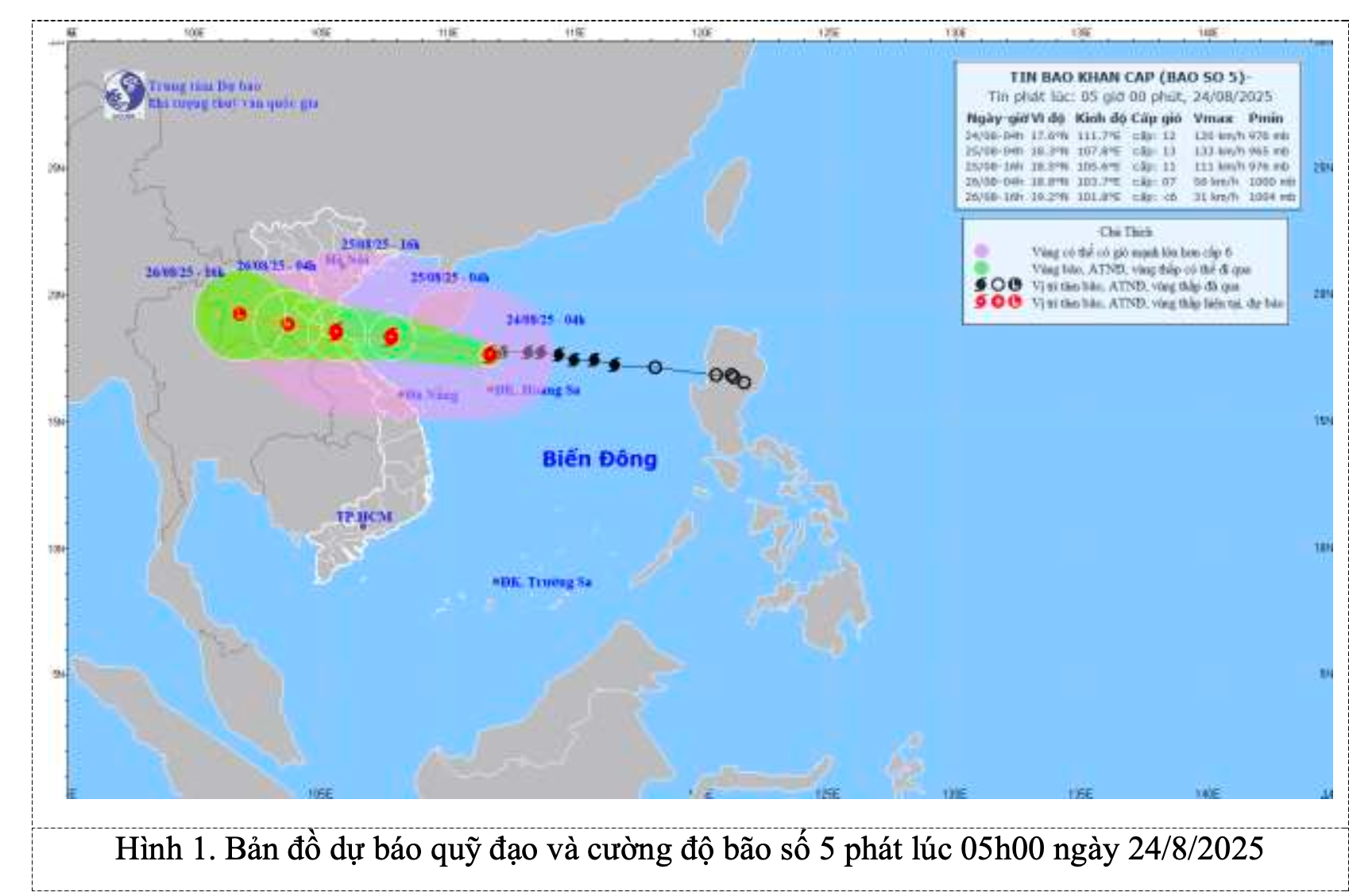
According to the Hai Phong City Meteorological and Hydrological Station, at 4:00 AM on August 24th, the typhoon's center was located at approximately 17.6 degrees North latitude and 111.7 degrees East longitude, in the sea north of the Hoang Sa Special Zone, about 660km east-southeast of Nghe An and about 640km east of Ha Tinh . The strongest winds near the center of the typhoon reached level 12 (118-133 km/h), with gusts up to level 15; it was moving westward at a speed of about 20 km/h.
Forecast of storm developments (over the next 24 to 60 hours):
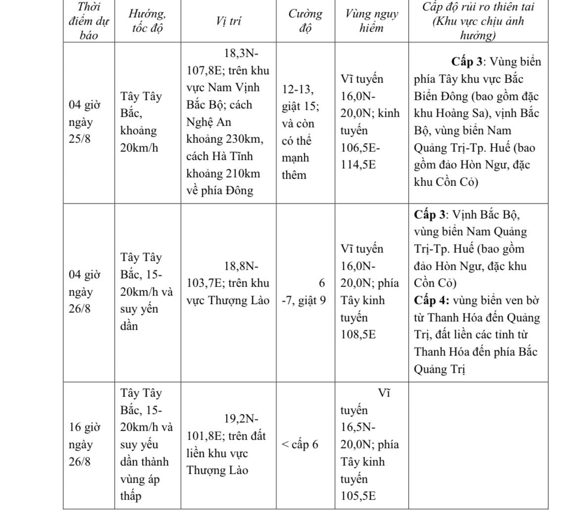
Due to the impact of the storm, the western sea area of the North East Sea (including the Hoang Sa special zone) will experience strong winds of force 8-10, reaching force 11-13 near the storm's center, with gusts up to force 15. Sea waves will be 5.0-7.0m high, and 7.0-9.0m near the storm's center, resulting in extremely rough seas.
From noon and afternoon of August 24th, the sea area from Thanh Hoa to Hue City (including Hon Ngu Island and Con Co Special Economic Zone) will experience gradually increasing winds of force 6-8, then increasing to force 9-10, reaching force 11-13 near the storm's center, with gusts up to force 15; sea waves will be 4.0-6.0m high, 7.0-9.0m near the center; the sea will be extremely rough.
From the afternoon of August 24th, the northern part of the Gulf of Tonkin (including the special economic zones of Cat Hai, Co To, and Van Don) will experience increasingly strong winds of force 6-7, gusting to force 9; in the southern part of the northern Gulf of Tonkin (including the Bach Long Vi special economic zone), winds will be strong at force 8, gusting to force 10; sea waves will be 2.0-4.0m high; the sea will be rough.
Coastal areas from Ninh Binh to northern Quang Tri are experiencing storm surges of 0.5-1.5m. Water levels at monitoring stations in Sam Son (Thanh Hoa) are 3.3-3.8m, at Hon Ngu ( Nghe An ) 3.5-4.0m, at Vung Ang (Ha Tinh) 2.5-3.0m, and at Cua Gianh (Quang Tri) 1.5-2.0m. There is a high risk of flooding in low-lying coastal areas, river mouths, and islands from Thanh Hoa to northern Quang Tri.
Weather warnings for the sea and coastal areas during the storm indicate extremely dangerous conditions, making it unsafe for any vehicles or structures operating in the hazardous zone, such as: tourist boats, passenger ships, cargo ships, cages, rafts, aquaculture farms, dikes, embankments, and coastal roads. Vehicles are at high risk of capsizing or destruction; flooding is possible due to strong winds, high waves, and rising sea levels.
From the night of August 24th, strong winds will gradually increase to level 7-9 on land from Thanh Hoa to Quang Tri, reaching level 10-12 near the storm's center, with gusts up to level 14-15; strong winds will gradually increase to level 6-7 along the coastal areas of provinces from Quang Ninh to Ninh Binh, with gusts up to level 8.
From the night of August 24th to the end of August 26th, a widespread heavy rain event is likely to occur in the Northern Delta region, southern Phu Tho, and from Thanh Hoa to Hue City, with rainfall amounts generally ranging from 100-150mm, and locally exceeding 250mm; particularly in the area from Thanh Hoa to northern Quang Tri, there will be heavy to very heavy rain with rainfall amounts generally ranging from 200-400mm, and locally exceeding 700mm. A warning is issued regarding the risk of heavy rainfall (>200mm/3h).
From August 25-26, Hanoi and Da Nang will experience moderate to heavy rain and thunderstorms; Ho Chi Minh City will have rain, showers, and thunderstorms in the late afternoon and evening. During thunderstorms, be aware of the risk of tornadoes and strong gusts of wind.
From August 25-27, the Upper and Central regions of Laos are likely to experience heavy rainfall with common amounts of 100-250mm, and in some areas of Central Laos, exceeding 500mm.
Forecast of the storm's impact on Hai Phong city.
From the afternoon of August 24th, the northern part of the Gulf of Tonkin (including the Bach Long Vi special economic zone) experienced strong winds of force 8, gusting to force 10, with waves 2.0-4.0m high; the sea was rough.
From the night of August 24th, the sea area of Cat Hai special zone experienced strong winds of force 6-7, gusting to force 8-9, with waves 1.0-2.0m high and rough seas.
From the night of August 24th, the coastal areas of Hai An Ward, Dong Hai Ward, Nam Trieu Ward, Do Son Ward, Nam Do Son Ward, Duong Kinh Ward, Chan Hung Commune, Hung Thang Commune, and Kien Hai Commune will experience increasingly strong winds, reaching levels 4-5, gusting to levels 6-7, with waves 0.5-1.0m high.
On land: From the morning of August 25th, the following wards will experience winds of force 3-4, sometimes force 5, gusting to force 6, with the impact of strong winds: Thuy Nguyen, Thien Huong, Hoa Binh, Bach Dang, Luu Kiem, Le Ich Moc, Viet Khe commune, Hong Bang ward, Hong An ward, Ngo Quyen ward, Gia Vien ward, Le Chan ward, An Bien ward, An Duong ward, An Hai ward, An Phong ward, An Truong commune, Kien An ward, Phu Lien ward, Hung Dao ward, An Hung commune, An Khanh commune, An Quang commune, An Lao commune, Kien Thuy commune, Kien Minh commune, Kien Hung commune, Nghi Duong commune, Quyet Thang commune, Tien Lang commune, Tan Minh commune, Tien Minh commune, Vinh Bao commune, Nguyen Binh Khiem commune, Vinh Am commune, Vinh Hai commune, Vinh Hoa commune, Vinh Thinh commune, Vinh Thuan commune.
Coastal areas are extremely dangerous during the storm, making it unsafe for any vehicles or structures operating in the hazardous zone, such as: tourist boats, passenger ships, cargo ships, cages, rafts, aquaculture farms, dikes, embankments, and coastal roads. Vehicles are at high risk of capsizing or destruction; flooding due to strong winds, high waves, and storm surges. All vessels, mooring areas, aquaculture farms, sea dikes, and other activities in these sea areas are at very high risk of being affected by thunderstorms, tornadoes, strong winds, and high waves. Strong winds and gusts can cause trees to fall, damage houses, transportation infrastructure, and endanger human lives. The level of natural disaster risk due to the storm is level 3.
From the night of August 24th to the end of August 26th, the entire city of Hai Phong experienced moderate to heavy rain, with some areas experiencing very heavy rain and thunderstorms.
In the Gulf of Tonkin (including the Bach Long Vi special economic zone), there will be heavy to very heavy rain and thunderstorms, with rainfall amounts generally ranging from 100-150mm.
Over the sea area of Hai Phong (including the Hai Cat special zone and Do Son ward), there will be moderate to heavy rain, with some areas experiencing very heavy rain, with rainfall amounts generally ranging from 80-120mm, and some localized areas exceeding 120mm.
Inland areas (including all remaining communes/wards) will experience moderate to heavy rain, with some areas experiencing very heavy rain, with rainfall amounts generally ranging from 50-100mm, and locally exceeding 100mm. During thunderstorms, there is a possibility of tornadoes, lightning, and strong gusts of wind.
Warning regarding the level of risk from heavy rainfall: Level 1.
Source: https://baohaiphong.vn/thong-tin-moi-nhat-ve-bao-so-5-518946.html
![[Image] A dreamy "livable city" under pink clouds](https://vphoto.vietnam.vn/thumb/1200x675/vietnam/resource/IMAGE/2026/02/24/1771930060937_tp4-jpg.webp)


![[Photo] Head of the Central Propaganda and Mass Mobilization Department visits and congratulates the Ministry of Health and the Military Traditional Medicine Institute.](https://vphoto.vietnam.vn/thumb/1200x675/vietnam/resource/IMAGE/2026/02/24/1771938483290_img-2682-3562-jpg.webp)


![[Photo] White pear blossoms bloom across the border of Pho Bang](https://vphoto.vietnam.vn/thumb/1200x675/vietnam/resource/IMAGE/2026/02/24/1771927665653_a8-8280-jpg.webp)


Comment (0)