
According to the National Center for Hydro-Meteorological Forecasting, at 7:00 AM on June 9th, a low-pressure trough connected to a low-pressure area over the northern South China Sea was located at approximately 17.0 - 18.0 degrees North latitude; 117.2 - 118.2 degrees East longitude.
The forecast for the next 24 hours indicates that the low-pressure area will move slowly westward and has the potential to strengthen into a tropical depression.
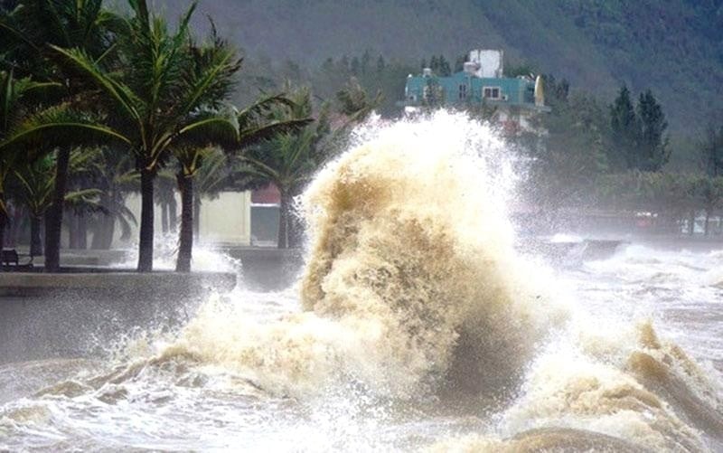
On June 9th, both day and night, heavy rain and thunderstorms are expected in the northern South China Sea (including the waters around the Hoang Sa archipelago), the central and southern South China Sea (including the waters around the Truong Sa archipelago), the sea area from Binh Dinh to Ca Mau, Ca Mau to Kien Giang , and the Gulf of Thailand. During thunderstorms, tornadoes, strong gusts of wind (level 6-7), and waves exceeding 2 meters are possible.
Additionally, in the sea area from Binh Thuan to Ca Mau, the southern part of the central East Sea, and the southern East Sea (including the sea area around the Spratly Islands), strong southwest winds of force 5, sometimes force 6, gusting to force 7-8, will cause rough seas with waves 1.5-3 meters high.
In mainland Vietnam, last night and this morning, the Northern region experienced showers and scattered thunderstorms, with localized heavy to very heavy rainfall. Rainfall amounts from 7 PM on June 8th to 8 AM on June 9th exceeded 70 mm in some areas, such as: Lung Ha ( Yen Bai ) 115.2 mm; Yen Hoa (Tuyen Quang) 87.8 mm; Vinh Phuc (Ha Giang) 75.2 mm…
From the evening of June 9th to the morning of June 10th, the mountainous and midland areas of Northern Vietnam will continue to experience moderate to heavy rain and thunderstorms, with localized very heavy rain. Total rainfall will generally range from 30 to 70 mm, with some areas exceeding 150 mm. The Northern Delta and Thanh Hoa will experience showers and scattered thunderstorms, with localized heavy rain, with rainfall ranging from 20 to 40 mm, and some areas exceeding 80 mm.
The meteorological agency warned of the risk of heavy rainfall, with precipitation exceeding 100 mm in just 3 hours, increasing the likelihood of flash floods and landslides in mountainous areas and flooding in urban areas and low-lying regions.
Additionally, on the afternoon and evening of June 9th, the Central Highlands and Southern Vietnam will maintain a weather pattern of rain, moderate rain, and thunderstorms, with localized heavy rain, with rainfall amounts of 20-40 mm, and in some places over 70 mm. South Central Vietnam will experience showers and thunderstorms, with localized heavy rain, with rainfall amounts of 10-30 mm, and in some places over 50 mm.
From the afternoon of June 10th, heavy rain in Northern Vietnam gradually subsided.
TH (according to VTC News)Source: https://baohaiduong.vn/ap-thap-nhiet-doi-kha-nang-hinh-thanh-tren-bien-dong-trong-24-gio-toi-413592.html
![[Photo] Prime Minister Pham Minh Chinh presides over a meeting on private sector economic development.](/_next/image?url=https%3A%2F%2Fvphoto.vietnam.vn%2Fthumb%2F1200x675%2Fvietnam%2Fresource%2FIMAGE%2F2025%2F12%2F20%2F1766237501876_thiet-ke-chua-co-ten-40-png.webp&w=3840&q=75)
![[Photo] Prime Minister Pham Minh Chinh presides over the conference announcing the establishment of the International Finance Centre in Vietnam.](/_next/image?url=https%3A%2F%2Fvphoto.vietnam.vn%2Fthumb%2F1200x675%2Fvietnam%2Fresource%2FIMAGE%2F2025%2F12%2F21%2F1766309817714_ndo_br_dsc-3400-jpg.webp&w=3840&q=75)


Comment (0)