
Forecasts indicate that the tropical depression is likely to strengthen over the next 24 hours. By 1:00 AM on September 18th, the center of the tropical depression will be located at approximately 19.2 degrees North latitude and 120.3 degrees East longitude, over the sea north of Luzon Island (Philippines), with a strength of level 8, gusts of level 10, and the potential to intensify into a typhoon.
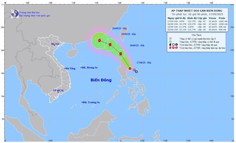
According to the National Center for Hydro-Meteorological Forecasting, at 1:00 AM on September 17th, the center of the tropical depression was located at approximately 16 degrees North latitude and 122.3 degrees East longitude, over the sea east of Luzon Island (Philippines).
The strongest winds near the center of the tropical depression are at level 7 (50–61 km/h), with gusts up to level 9. The tropical depression is moving in a west-northwest direction at a speed of approximately 15 km/h.
Forecast for the next 24 hours: The tropical depression is likely to strengthen. By 1:00 AM on September 18th, the center of the tropical depression will be located at approximately 19.2 degrees North latitude and 120.3 degrees East longitude, over the sea north of Luzon Island (Philippines), with a strength of level 8, gusts of level 10, and the potential to intensify into a typhoon. The risk of natural disaster is at level 3 in the northeastern part of the South China Sea.
By 1:00 AM on September 19th, the storm's center is expected to be located at approximately 21.2 degrees North latitude and 118.0 degrees East longitude, in the northeastern part of the South China Sea, with wind speeds of force 8-9, gusting to force 11. Over the next 48-72 hours, the storm will move west-northwest at a speed of 10-15 km/h, with little change in intensity.
From the night of September 17th, winds in the northeastern part of the South China Sea will gradually strengthen to force 6-7, gusting to force 9. Near the storm's center, winds will reach force 8, gusting to force 10, with waves 2.5-4.5m high and rough seas. There is a high risk for vessels operating in this dangerous area, as they may encounter thunderstorms, tornadoes, strong winds, and high waves. Throughout September 17th, both day and night, winds in the central South China Sea will reach force 5, sometimes force 6, gusting to force 7-8, with waves 2-3m high and rough seas.
On September 17th, both day and night, scattered showers and thunderstorms are expected in the northern, central, and southern areas of the South China Sea (including the waters around the Paracel and Spratly Islands), the Gulf of Tonkin, the sea area from southern Quang Tri to Ca Mau, from Ca Mau to An Giang , and the Gulf of Thailand; particularly in the northeastern part of the northern South China Sea, there will be storms.
During thunderstorms, there is a risk of tornadoes, strong gusts of wind (level 6-7), and waves over 2 meters high.
On land, last night and early this morning (September 17th), the area from Hue to Khanh Hoa experienced showers and thunderstorms, with some areas receiving heavy rain. Rainfall measured from 7 PM on September 16th to 3 AM on September 17th exceeded 50mm in some places, such as Quang Dien (Hue) with 68.2mm, Ia Kenh (Gia Lai) with 88.4mm, and Song Hinh ( Dak Lak ) with 51.8mm.
The forecast for the afternoon and night of September 17th indicates continued scattered showers and thunderstorms in the area from Hue to Lam Dong and the Southern region, with rainfall generally ranging from 15–30mm, and locally heavy rain exceeding 80mm. There is a possibility of heavy rainfall exceeding 80mm in 3 hours.
Given the complex developments of the tropical depression, which has the potential to strengthen into a storm, the meteorological agency advises ships operating at sea to closely monitor weather forecasts, proactively take precautions, and move out of dangerous areas; local authorities and people in coastal and island areas need to prepare timely response plans.
Source: https://baolamdong.vn/ap-thap-nhiet-doi-sap-manh-len-thanh-bao-bien-dong-manh-391754.html


![[Photo] General Secretary and President To Lam presides over a meeting with the Central Organizing Committee.](https://vphoto.vietnam.vn/thumb/1200x675/vietnam/resource/IMAGE/2026/06/03/1780482764658_a1-bnd-4741-3342-jpg.webp)
![[Photo] First session of the 14th Congress of the Vietnam Trade Union](https://vphoto.vietnam.vn/thumb/1200x675/vietnam/resource/IMAGE/2026/06/03/1780465947883_ndo_br_img-3852-jpg.webp)
![[Photo] Secretary of the National Assembly Party Committee, Chairman of the National Assembly presides over the meeting of the Standing Committee and Executive Committee of the National Assembly Party Committee.](https://vphoto.vietnam.vn/thumb/1200x675/vietnam/resource/IMAGE/2026/06/03/1780480353201_ndo_br_bnd-2585-jpg.webp)


![[Video] Sunset at Lap An Lagoon – Where the sun sets over the fishing nets](https://vphoto.vietnam.vn/thumb/1200x675/vietnam/resource/IMAGE/2026/05/31/1780192137701_beach-landscape-sea-water-nature-grass-745871-pxhere-com.jpeg)


Comment (0)