
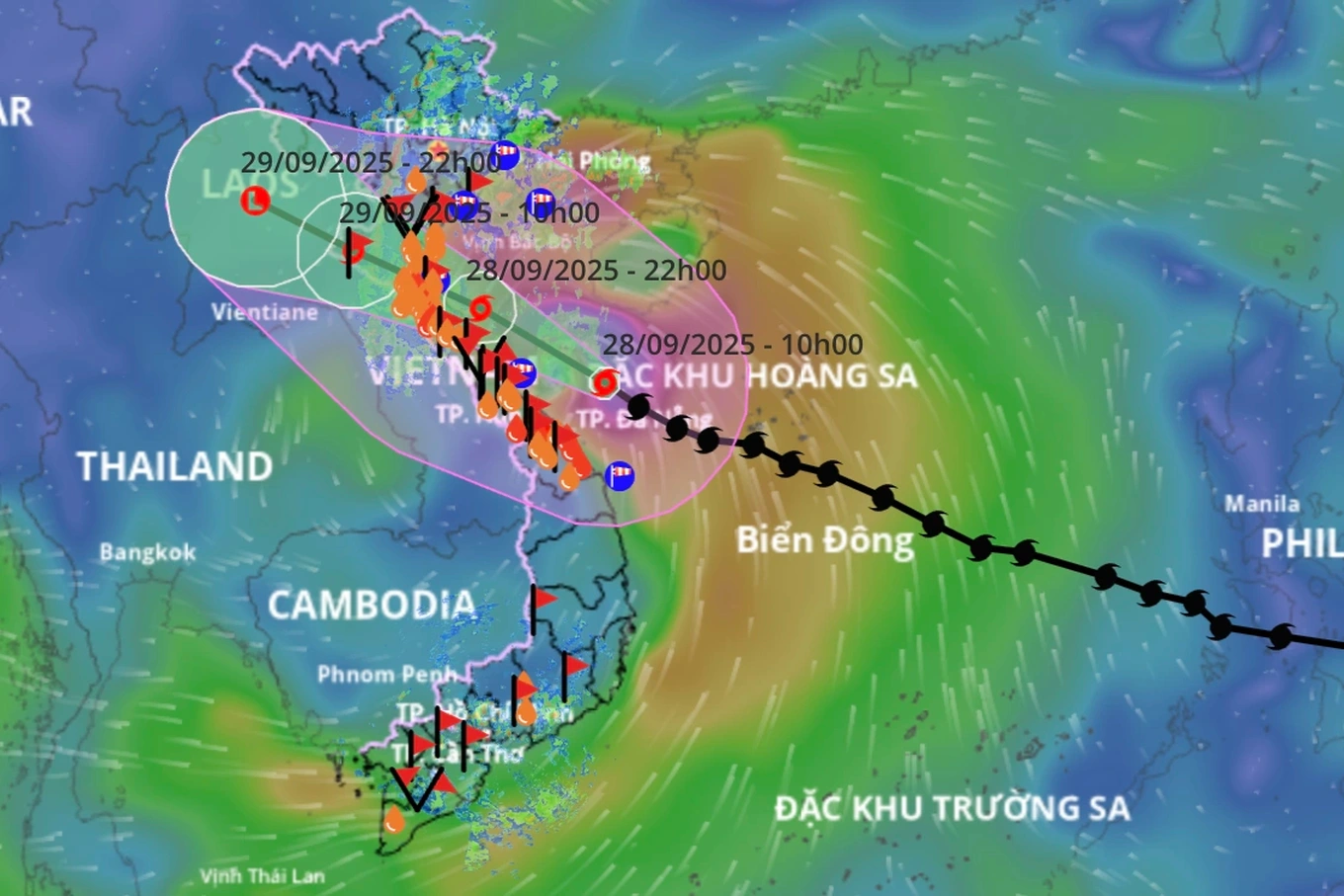
The National Center for Hydro-Meteorological Forecasting said that at 2:00 p.m. on September 28, Storm Bualoi (Storm No. 10) was about 90 km east-northeast of Nghe An and about 165 km south-southeast of Quang Tri. The strongest wind near the storm's center was level 12, gusting to level 15.
Thus, in the past 10 hours, storm Bualoi maintained level 12 intensity, gusting to level 15.
It is forecasted that in the next 3 hours, the storm will move in the West Northwest direction, at a speed of about 20-25km/h, making landfall in the Nghe An - Quang Tri area.
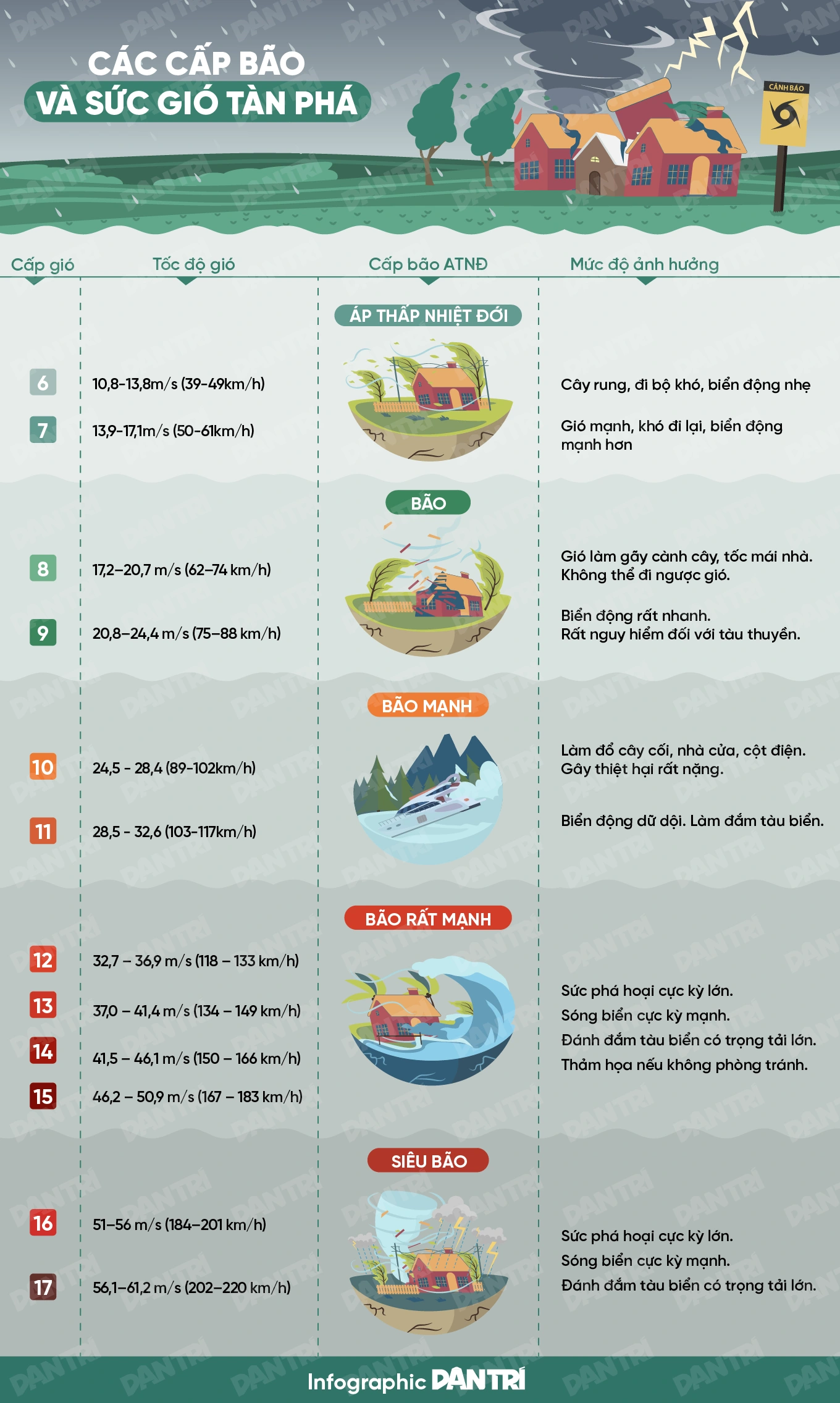
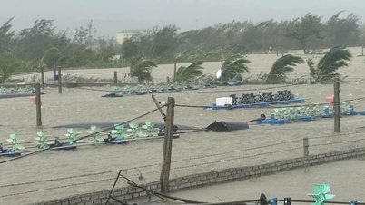
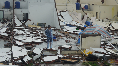
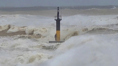
The meteorological agency assessed that this is a fast-moving storm with strong intensity and a wide range of influence, which can cause a combination of many types of natural disasters such as strong winds, heavy rains, flash floods, landslides and coastal flooding.
The movement of storm Bualoi (Photo: Vietnam Disaster Monitoring System).
Leaders of the National Center for Hydro-Meteorological Forecasting said that from about 10pm on September 28 to 1am on September 29, the storm's eye will make landfall in Nghe An - Northern Quang Tri.
According to this person, from noon on September 28, the wind on the mainland from Thanh Hoa to Northern Quang Tri gradually increased to level 6-7, then increased to level 8-9; near the storm center level 10-12, gusting to level 14. The strongest wind was from the evening until the end of the night of September 28, the storm's activity on the mainland was about 6-8 hours.
From noon to evening today, the coastal area of southern Quang Tri will have strong winds of level 6-7.
In addition, the area north of Quang Tri (old Quang Binh) has strong winds of level 8, the area near the storm center (the part bordering Ngang Pass) has strong winds of level 9-11, gusts of level 14, the strong winds last from 5pm to 11pm.
In Ha Tinh and Nghe An provinces, from the afternoon of September 28, there will be strong winds of level 6-7, from the evening and night there will be strong winds of level 8-9, coastal areas will have winds of level 10-12 (strong winds last from 7:00 p.m. to 11:00 p.m.), inland areas strong winds will last from 8:00 p.m. on September 28 to 2:00 a.m. on September 29.
In Thanh Hoa province, from the afternoon of September 28, there will be strong winds of level 6-7, the southern region of Thanh Hoa will have strong storm winds of level 8-10, gusting to level 13 (strong winds from 7pm to 11pm).
Regarding heavy rain, the hydrometeorological agency forecasts that on September 28-30, the Northern Delta, South Phu Tho, Thanh Hoa - North Quang Tri will have widespread rain of 200-400mm, locally over 600mm; other places will have widespread rain of 100-300mm, locally over 450mm.
According to forecasts, from September 28 to October 1, many rivers in the North and from Thanh Hoa to Hue will experience floods, with flood peaks reaching alert levels 2-3, and some places above alert level 3 such as Thao, Hoang Long, Ma, Chu, Ca, Ngan Sau, Ngan Pho, Kien Giang rivers....
Besides, some other big rivers reached alert level 1-2, some places above alert level 2 such as Lo, La, Gianh, Thach Han, Huong, Bo rivers.
The meteorological agency also warned of the risk of insecurity at sea-facing dikes with low elevations, especially at key locations such as Dong Minh dike (Hung Yen), Con Tron - Hai Thinh - Thinh Long sea dike (Ninh Binh), Quang Nham - Hai Binh (Thanh Hoa), Dien Thanh - Quynh Tho - Long Thuan (Nghe An), Ta Nghen - Cam Nhuong - Hoi Thong (Ha Tinh), Vinh Thai (Quang Tri)...
In addition, the meteorological agency warned of the risk of very heavy rain in the basins of large reservoirs such as Hua Na, Cua Dat (Thanh Hoa), Ban Ve (Nghe An), Ho Ho (Quang Binh), and the lakes of Hoa Binh, Son La, Tuyen Quang, and Thac Ba (Northern Vietnam).
Dantri.com.vn
Source: https://dantri.com.vn/thoi-su/bao-bualoi-duy-tri-cuong-do-cap-12-tien-sat-dat-lien-nghe-an-quang-tri-20250928142938790.htm
![[Photo] General Secretary To Lam attends the ceremony to celebrate the 80th anniversary of the post and telecommunications sector and the 66th anniversary of the science and technology sector.](https://vphoto.vietnam.vn/thumb/1200x675/vietnam/resource/IMAGE/2025/9/29/8e86b39b8fe44121a2b14a031f4cef46)
![[Photo] General Secretary To Lam chairs the meeting of the Central Steering Committee on preventing and combating corruption, waste and negativity](https://vphoto.vietnam.vn/thumb/1200x675/vietnam/resource/IMAGE/2025/9/29/fb2a8712315d4213a16322588c57b975)

![[Photo] National Assembly Chairman Tran Thanh Man chairs the 8th Conference of full-time National Assembly deputies](https://vphoto.vietnam.vn/thumb/1200x675/vietnam/resource/IMAGE/2025/9/29/2c21459bc38d44ffaacd679ab9a0477c)
![[Photo] Many streets in Hanoi were flooded due to the effects of storm Bualoi](https://vphoto.vietnam.vn/thumb/1200x675/vietnam/resource/IMAGE/2025/9/29/18b658aa0fa2495c927ade4bbe0096df)


Comment (0)