

According to experts from the National Center for Hydro-Meteorological Forecasting, this morning (August 22), a low pressure area in the eastern part of Luzon Island (Philippines) has strengthened into a tropical depression.
Around tonight, the tropical depression will move into the East Sea, likely strengthening into a storm, the 11th storm in the Northwest Pacific region and the 5th storm in the East Sea (international name is Kajiki).
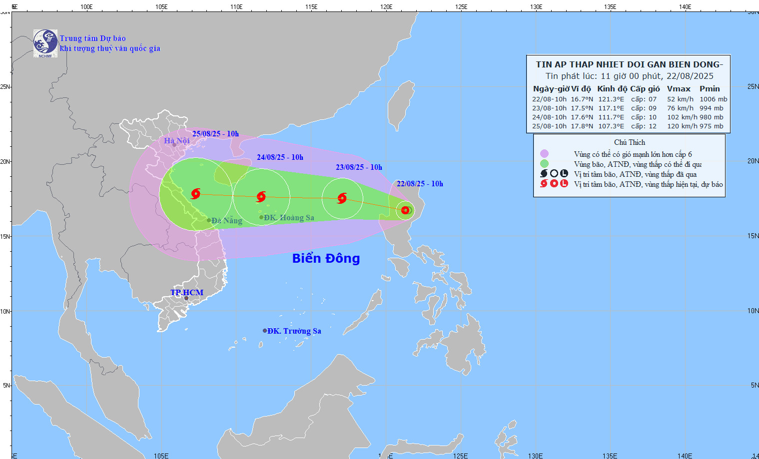
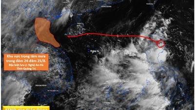
Storm No. 5 is forecast to move inland on August 25 when it forms. Source: NCHMF
The above developments were reported at a meeting to prepare for the development of a tropical depression into a storm in the coming hours at the Operation Center of the Department of Hydrometeorology, at noon on August 22. Deputy Minister of Agriculture and Environment Nguyen Hoang Hiep chaired the meeting.
Mr. Mai Van Khiem, Director of the National Center for Hydro-Meteorological Forecasting, said that when entering the East Sea, storm No. 5 will move quickly, at a speed of about 20km/h. Around August 24, when the storm moves to the Hoang Sa archipelago, its intensity may reach level 10-11, gusting to level 13-14, and it may even strengthen when moving into the Gulf of Tonkin.
"It is forecasted that on August 25, storm No. 5 will move to the mainland of our country," Mr. Khiem informed.
Due to the influence of the storm circulation in the Northern and Central areas of the East Sea (including Hoang Sa special zone), from tomorrow (August 23), there will be strong winds of level 6-7, then increasing to level 8-9, from August 24, strong winds will increase to level 10-11, gusting to level 13-14; waves from 4-7m high, very rough seas with thunderstorms, whirlwinds and heavy rain.
The sea area from Thanh Hoa - Da Nang from August 25 will have strong storm winds of level 8, near the storm center of level 11-12, gusting to level 15.
Heavy rain across North and Central Central regions
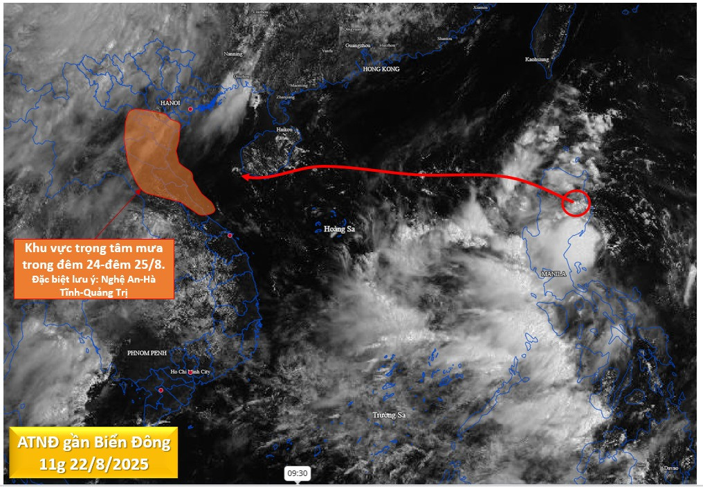
Mr. Mai Van Khiem emphasized that with the current impact scenario (11am on August 22), the storm's circulation is very wide, affecting the coast of the North and North Central regions, in which the coastal area from Nghe An - Quang Tri will be the main affected area, with the possibility of strong coastal winds of level 10-11, gusting to level 13-14.
Thus, the preparation and response time is quite short (about 2 days) before strong winds and heavy rains begin to occur in the area from Thanh Hoa to Hue from the night of August 24, lasting until the end of the night of August 25.

Mr. Mai Van Khiem, Director of the National Center for Hydro-Meteorological Forecasting, reported on the developments and initial forecast of the tropical depression that is likely to strengthen into a storm. Photo: Department of Hydro-Meteorological Forecasting
Specifically, from the night of August 24 to the end of August 27, in the area from Thanh Hoa - Hue City, there was a period of heavy to very heavy rain, with rainfall ranging from 150-300mm, in some places over 600mm.
There is a flood on the rivers from Thanh Hoa to Quang Tri. There is a risk of flash floods, landslides and inundation in low-lying areas, riverbanks, and urban areas in the provinces in the above region. Localities need to proactively deploy flood prevention plans, check residents in dangerous areas, and ensure the safety of reservoirs and flood prevention works.
Low pressure becomes storm very briefly, need to proactively prevent early
Mr. Hoang Duc Cuong, Deputy Director of the Department of Hydrometeorology, commented on the complexity of the storm.
“Because the storm is currently forming and developing, the impact on areas entering the East Sea and near the shore will still have many unpredictable changes,” said Mr. Cuong.
However, Mr. Cuong emphasized that due to the short development of the low pressure into a storm, it is necessary to pay close attention to the response direction to proactively prevent from now on. Before the storm, it is necessary to monitor and prevent the risk of thunderstorms and lightning at sea and in coastal areas.

Deputy Minister of Agriculture and Environment Nguyen Hoang Hiep chaired the meeting.
Deputy Minister Nguyen Hoang Hiep requested the Department of Hydrometeorology to direct the Forecast Center and units in the forecasting system in coastal localities in the North Central region to improve early warning forecasting capacity.
"Units need to try to provide accurate and early information to local authorities, maybe even 30 minutes to 1 hour in advance, to promptly direct response to stop activities at sea, bring ships back to safe shelters, and avoid unfortunate incidents," Mr. Hiep noted.
Mr. Hiep also requested the Department of Dykes and Natural Disaster Prevention and Control to promptly draft a document to send to the Ministry of Industry and Trade to coordinate in reviewing dams; at the same time, instruct and advise localities on residential safety, production and tourism as well as important events at the Central and local levels before and during the 80th anniversary of National Day, September 2.
Tropical depression about to enter the East Sea
At 10:00 a.m. on August 22, the center of the tropical depression was located on the mainland of Luzon Island (Philippines). The strongest wind near the center of the tropical depression was level 6-7 (39-61 km/h), gusting to level 9; moving northwest at a speed of 10-15 km/h.
The movement direction of the tropical depression may strengthen into storm No. 5, updated at noon on August 22. Source: NCHMF
It is forecasted that in the next 24 hours, the tropical depression will move west-northwest at a speed of 15-20km/h, strengthening into a storm, storm number 5 Kajiki. At 10:00 on August 23, the center of the storm will be in the eastern sea of the North East Sea; 560km east-northeast of Hoang Sa special zone with an intensity of level 8-9, gusting to level 11.
In the next 24 hours, the storm changed direction and increased speed, moving west at about 20km/h and continued to strengthen. At 10am on August 24, the storm's center was located in the sea north of Hoang Sa special zone, level 10-11, gusting 14.
In the next 48 to 72 hours, the storm will move mainly in a westerly direction, about 20km per hour, and is likely to strengthen.
Due to the influence of the tropical depression that later strengthened into a storm, the eastern sea area of the North East Sea had showers and thunderstorms, strong winds of level 6-7, later increasing to level 8-9, gusting to level 11, waves 3-5m high, very rough seas.
Vietnamnet.vn
Source: https://vietnamnet.vn/bao-so-5-sap-hinh-thanh-cuong-do-cuc-dai-giat-cap-15-du-bao-vao-dat-lien-25-8-2434841.html
![[Photo] President Luong Cuong receives delegation of the Youth Committee of the Liberal Democratic Party of Japan](https://vphoto.vietnam.vn/thumb/1200x675/vietnam/resource/IMAGE/2025/8/22/2632d7f5cf4f4a8e90ce5f5e1989194a)
![[Photo] Prime Minister Pham Minh Chinh chairs the conference to review the 2024-2025 school year and deploy tasks for the 2025-2026 school year.](https://vphoto.vietnam.vn/thumb/1200x675/vietnam/resource/IMAGE/2025/8/22/2ca5ed79ce6a46a1ac7706a42cefafae)


![[Photo] President Luong Cuong attends special political-artistic television show "Golden Opportunity"](https://vphoto.vietnam.vn/thumb/1200x675/vietnam/resource/IMAGE/2025/8/22/44ca13c28fa7476796f9aa3618ff74c4)


Comment (0)