
On the evening of October 21st, Mr. Nguyen Van Huong, Head of the Weather Forecasting Department at the National Center for Meteorological and Hydrological Forecasting, stated that a tropical depression is currently active in the area east of the Philippines.
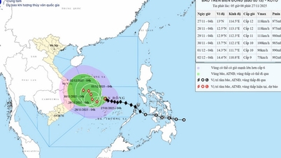
At 4 PM on the same day, the center of the tropical depression was located at approximately 13.5 degrees North latitude and 131.0 degrees East longitude, about 1,300 km southeast of Luzon Island (Philippines). The strongest winds near the center of the tropical depression were at level 7 (50-61 km/h), with gusts up to level 9.

A tropical depression off the coast of the Philippines is likely to strengthen into a typhoon, possibly moving into the South China Sea around October 25th. (Illustrative image)
The forecast for the next 24 hours indicates that the tropical depression will move mainly in a west-northwest direction and has the potential to strengthen into a typhoon.
As of 4 PM on October 22nd, the typhoon's center was located at approximately 14.8 degrees North latitude and 127.1 degrees East longitude, in the sea east of the Philippines. The strongest winds near the center of the typhoon were at level 8 (62-75 km/h), with gusts up to level 11. Sea waves were 3-4 meters high.
Forecasts indicate that around October 25th, the storm is likely to move into the South China Sea, becoming the sixth storm of 2024.
From around the afternoon and night of October 24th, the eastern sea area of the North East Sea (east of 118.5 degrees East longitude) will experience increasingly strong winds, reaching level 8, with winds near the storm's center reaching levels 9-10, gusting to level 12. The sea will be very rough, with waves 3-5 meters high, accompanied by thunderstorms and dangerous tornadoes.
In mainland Vietnam, over the next 24 to 48 hours, the Northwest region will experience scattered showers and thunderstorms in some areas, with scattered showers and thunderstorms in some places from the afternoon of October 22nd.
In the Northeast region, there will be scattered showers and thunderstorms in some areas, with scattered showers and thunderstorms in places during the afternoon and night of October 22nd.
From Thanh Hoa to Quang Binh and Phu Yen, there will be rain, moderate rain, with some areas experiencing heavy rain and scattered thunderstorms.
From Quang Tri to Binh Dinh, there will be moderate to heavy rain and scattered thunderstorms, with very heavy rain in some areas.
Other areas will experience scattered showers and thunderstorms, with more widespread showers and thunderstorms in the afternoon and evening, including localized heavy rain in the Southern Central Highlands and Southern Vietnam.
Source: https://vtcnews.vn/bien-dong-kha-nang-sap-don-con-bao-so-6-ar903060.html


Comment (0)