
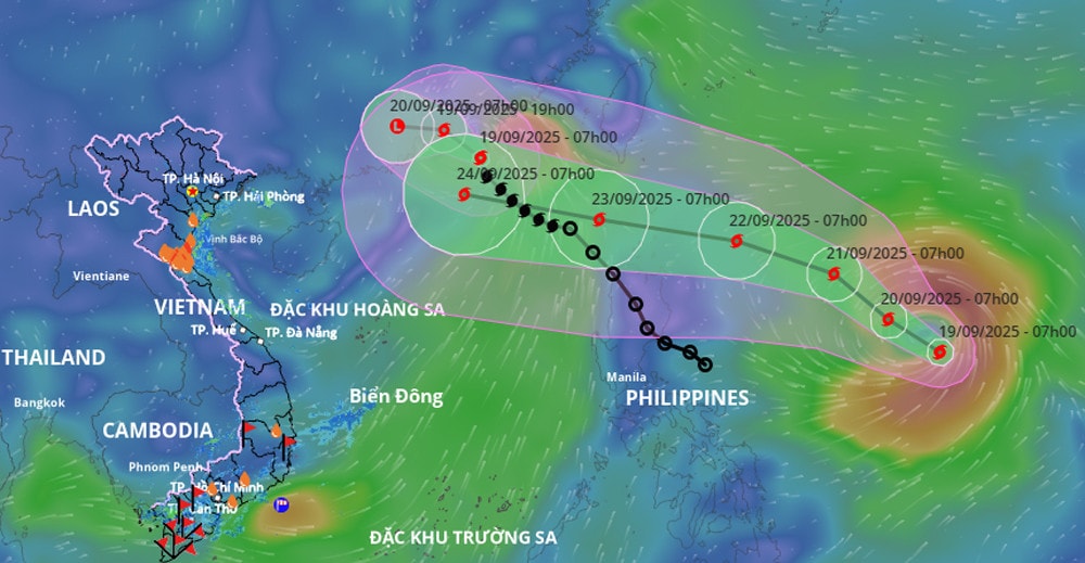
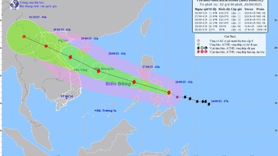
This morning (September 19), the National Center for Hydro-Meteorological Forecasting said that Ragasa is active in the sea east of the Philippines. Around September 23, Ragasa will enter the East Sea, becoming the 9th storm of 2025.
Experts predict that this is a very strong storm, possibly reaching super typhoon level (level 16, gusts above level 17), with waves over 10m high, rough seas, especially dangerous for ships operating in the North and Central East Sea.
At 7:00 a.m., the storm center was at about 15.7 degrees North latitude; 131.9 degrees East longitude, about 1,000 km east of Luzon Island (Philippines) with the strongest wind at level 8 (62-74 km/h), gusting to level 10. The storm moved northwest at a speed of about 10 km/h.
Forecast (next 24–72 hours) :
By 7am on September 20: the storm will move to the Northwest, about 10km/h, possibly strengthening to level 10, gusting to level 12, at 16.8 degrees North latitude - 130.1 degrees East longitude.
At 7:00 a.m. on September 21: continue to the Northwest, 10km/h, strengthening to level 12-13, gusting to level 16, at position 18.3 degrees North latitude - 128.2 degrees East longitude.
Until 7am on September 22: going West Northwest, 10-15 km/h, strengthening to level 14-15, gusting over level 17, at position 19.4 degrees North latitude - 124.8 degrees East longitude.
Development warning (next 72–120 hours): The storm continues to move mainly in the West-Northwest direction, at a speed of about 20km/h and is likely to strengthen.
Impact forecast :
From the afternoon and night of September 22, the northeastern sea area of the East Sea had strong winds of level 6 - 7, then increased to level 8 - 9. From September 23, the northern East Sea area (including Hoang Sa special zone) was directly affected by storm Ragasa with very strong intensity, level 14 - 16, gusting over level 17. Waves were over 10m high, the sea was rough, especially dangerous for ships operating in the northern and central East Sea areas.
According to experts, this storm is likely to directly affect mainland Vietnam between September 24 and 26. This is a strong storm, capable of causing strong winds and heavy rains in the Northern region and provinces from Thanh Hoa to Hue.
The National Center for Hydro-Meteorological Forecasting is closely monitoring the developments of this Ragasa storm.
PVSource: https://baohaiphong.vn/lai-mot-con-bao-moi-dang-tien-vao-bien-dong-cuong-do-co-the-dat-cap-sieu-bao-521218.html


![[Video] Hue Monuments reopen to welcome visitors](https://vphoto.vietnam.vn/thumb/402x226/vietnam/resource/IMAGE/2025/11/05/1762301089171_dung01-05-43-09still013-jpg.webp)


![Dong Nai OCOP transition: [Part 2] Opening new distribution channel](https://vphoto.vietnam.vn/thumb/402x226/vietnam/resource/IMAGE/2025/11/09/1762655780766_4613-anh-1_20240803100041-nongnghiep-154608.jpeg)


Comment (0)