
Hurricane Melissa became one of the strongest hurricanes ever recorded in the Atlantic, with record-breaking wind speeds and low pressure, prompting scientists to warn of a trend toward extreme weather events due to climate change.
Melissa reached Category 5 – the highest level on the Saffir-Simpson hurricane scale, with sustained winds of up to 305 km/h. The hurricane's central pressure dropped to just 882 hPa, making it one of the lowest-pressure hurricanes ever recorded in the Atlantic.
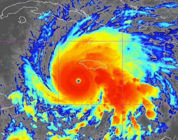
Hurricane Melissa reached Category 5 status as it approached the Jamaican coast on October 28. (Source: NOAA)
Hurricane Melissa's wind speeds surpass even the strongest Pacific hurricanes since the beginning of 2025, such as Ragasa (260 km/h) or Wipha (120 km/h), making it the strongest hurricane globally in 2025.
Melissa intensified extremely rapidly within just 24 hours, a phenomenon that has become increasingly common in recent years. Meteorologists call this “rapid intensification” and warn that it is occurring more frequently due to rising sea surface temperatures.
According to experts, unusually high sea surface temperatures in the area where Hurricane Melissa formed were the main factor contributing to its strength. Warm seas provide energy for hurricanes, and as global temperatures rise, storms tend to become stronger and more dangerous.
Although Melissa did not make direct landfall, it caused large waves, strong winds, and heavy rain in many coastal areas. Authorities evacuated thousands of people and issued flood warnings in several US states and the Caribbean.
Melissa is being closely monitored by climate and weather researchers, as it provides crucial data on future storm trends. Many experts believe this is a clear indication of the need for urgent action to reduce greenhouse gas emissions and adapt to extreme weather events.
Source: https://vtcnews.vn/sieu-bao-melissa-dau-hieu-cua-thoi-tiet-cuc-doan-do-bien-doi-khi-hau-ar983856.html


Comment (0)