
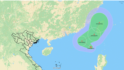
On the evening of July 3, the Department of Dyke Management and Natural Disaster Prevention informed that Deputy Minister of Agriculture and Environment Nguyen Hoang Hiep had just signed an official dispatch to the People's Committees of coastal provinces and cities from Quang Ninh to An Giang, requesting proactive response to the low pressure area in the East Sea that is likely to strengthen into a tropical depression, and at the same time warning of strong winds at sea.

The dispatch was sent after the Department of Hydrometeorology reported at 1 p.m. on July 3 that a low pressure area had formed in the northeastern region of Luzon Island (Philippines), located at about 18.5-19.5 degrees North latitude and 121.5-122.5 degrees East longitude.
Within 24 hours (from the afternoon of July 3), this low pressure area will move slowly in the West Northwest direction and is likely to strengthen into a tropical depression.
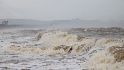
The cyclone in the East Sea tends to pull the southwest wind in the sea area from Lam Dong to Ca Mau to be strong at level 5, sometimes level 6, gusting to level 7, posing a high risk to ships operating at sea.

On the afternoon of July 3, the National Center for Hydro-Meteorological Forecasting said that the rainy area has been moving from the North to the Central region.
According to the stations on July 3, the provinces from Thanh Hoa to Da Nang City had localized rain such as Huong Lam 1 (Ha Tinh) 95.4mm and Giao Thuy (Da Nang) 91.2mm. The area from Gia Lai to Lam Dong also had localized rain over 70mm, while the South had places with heavy rain over 50mm but scattered.
On July 4, from Thanh Hoa to Quang Ngai, there will continue to be showers (over 80mm in some places).
Source: https://www.sggp.org.vn/bien-dong-chuan-bi-don-ap-thap-nhiet-doi-moi-post802347.html


Comment (0)