Continuously declare landslide emergency situation
On May 23, the People's Committee of Tra Vinh province decided to declare an emergency situation regarding the collapse and subsidence of the embankment protecting a vulnerable section of the coast in Duyen Hai town and an emergency situation regarding the landslide at the mouth of the Tra Cu river, Tra Cu district.
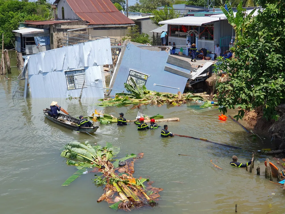
In Duyen Hai town, the embankment slope, embankment corridor and the area of rock and sand loss below the seawall are about 773m², endangering the embankment line. If not remedied immediately, the subsidence area will expand, develop further, causing the seawall to collapse, when seawater will flood in and cause great damage. The reason is that the embankment project protecting the vulnerable section was put into use since 2008, and is often strongly impacted and directly impacted by high tides, rising sea levels combined with strong winds and big waves.
Meanwhile, the emergency landslide incident at the Tra Cu river mouth area, Tra Cu district caused a riverbank landslide of about 20m long, eroding into the bank about 6m at the end of the Hau river embankment at the Tra Cu river mouth area. In addition, about 10m of the embankment lock collapsed, the embankment slab slid, sand in the embankment body flowed into the river, affecting 45 households (281 people), 1 temple and affecting production in the area, with the risk of damage to people's houses and 7.2 hectares of cultivated land. The cause of the landslide was due to high tides combined with big waves that caused riverbank erosion and embankment collapse in Tra Cu district.
The People's Committee of Tra Vinh province has directed relevant localities to put up warning signs in areas prone to subsidence and landslides; widely announce to people to be proactive in their daily life and production and prevent possible risks, ensuring safety. At the same time, arrange forces to closely monitor the developments of subsidence and landslides; prepare materials, human resources, and means to be ready to respond to proactively handle when subsidence and landslide incidents continue to threaten. The Department of Agriculture and Environment coordinates with localities to monitor developments, prepare response plans, regularly update and report the situation, and propose to the Provincial People's Committee to promptly handle...
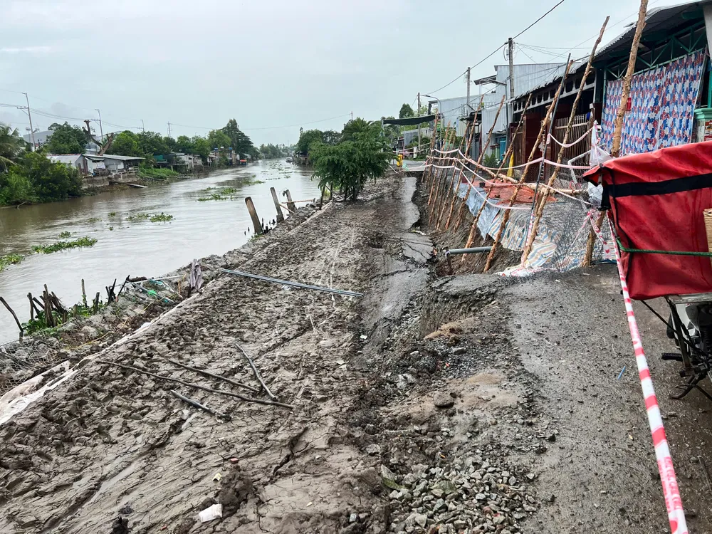
On May 24, the Department of Agriculture and Environment of An Giang province recorded 3 landslides on river banks and canals in the past 5 days. Of these, 2 landslides occurred in Cho Moi district and 1 occurred in Chau Thanh district. Accordingly, the landslide along the bank of Ong Chuong canal in Long Kien commune, Cho Moi district, appeared a crack of about 20m. In the crack area, there is a solidly built house but it is at risk of collapsing into Ong Chuong canal. This area is on the landslide warning list of the Department of Agriculture and Environment of An Giang province.
In An Thanh Trung commune, Long Kien commune, Cho Moi district, there was also a sudden subsidence on Vam Cai Ho road with a length of about 30m, eating into half of the road centerline, the subsidence part was about 0.8m deep.
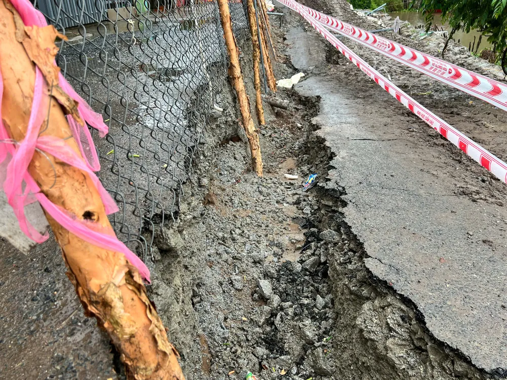
An Hoa Commune, Chau Thanh District, has had a landslide on a rural asphalt road about 50m long, eating into almost the entire road surface (4-5m depending on the section), close to the foundation of the houses. The road that has been eroded currently has about 0.7m of asphalt surface to the foot of the houses of the households living inside the edge of the road, with a difference of less than 1m compared to the surrounding area. This is also a road section that has just been built with an embankment to prevent landslides, but landslides have occurred. The piles and embankment nets have been pulled down by the entire land into the riverbed.
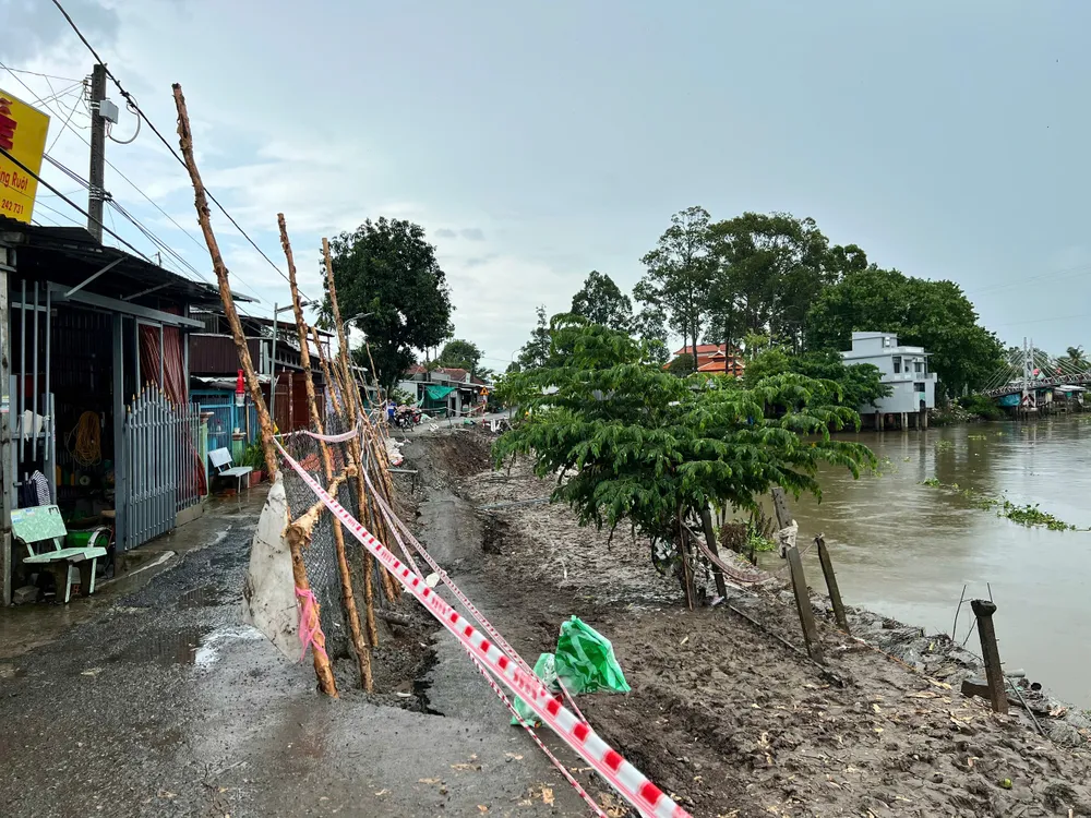
In Can Tho City, in the past 10 days, there have been two serious riverbank landslides. The most recent one occurred on the O Mon River in Tan Thanh Commune, Thoi Lai District, causing Mr. Nguyen Hoang D.'s house to collapse completely into the river, causing damage of about 150 million VND. The 2-meter rural traffic route along the O Mon River also collapsed from the riverbank to the mainland 2.5 meters, 35 meters long.
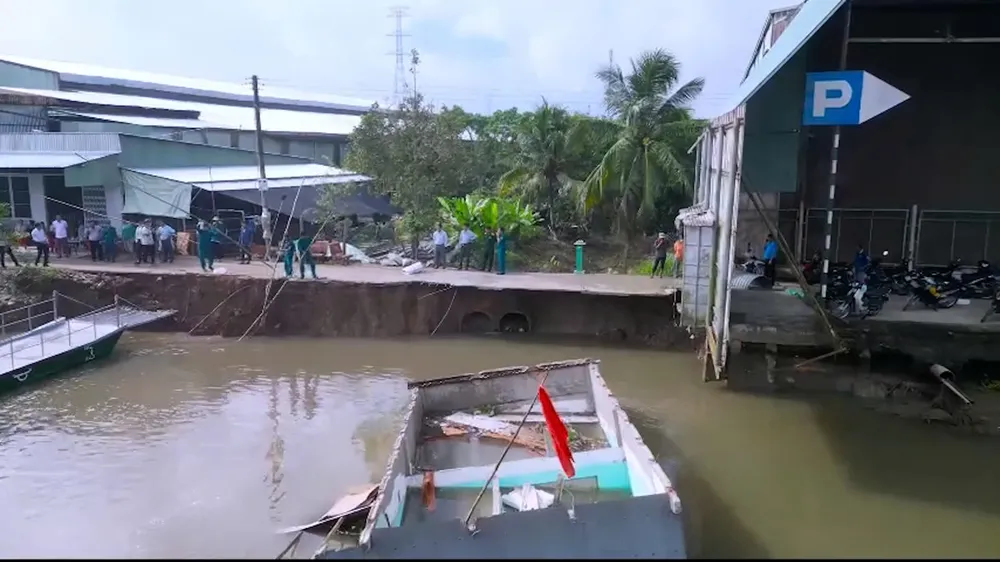
Previously, in Long Hung ward, O Mon district, a rural road subsidence of about 50m in length was recorded, causing a loss of water supply and cutting off traffic for local people. The incident caused surprise, panic and insecurity among local people. The subsidence section of the road was about 4m wide and nearly 50m long, and had just been upgraded from a 3m rural road not long ago.
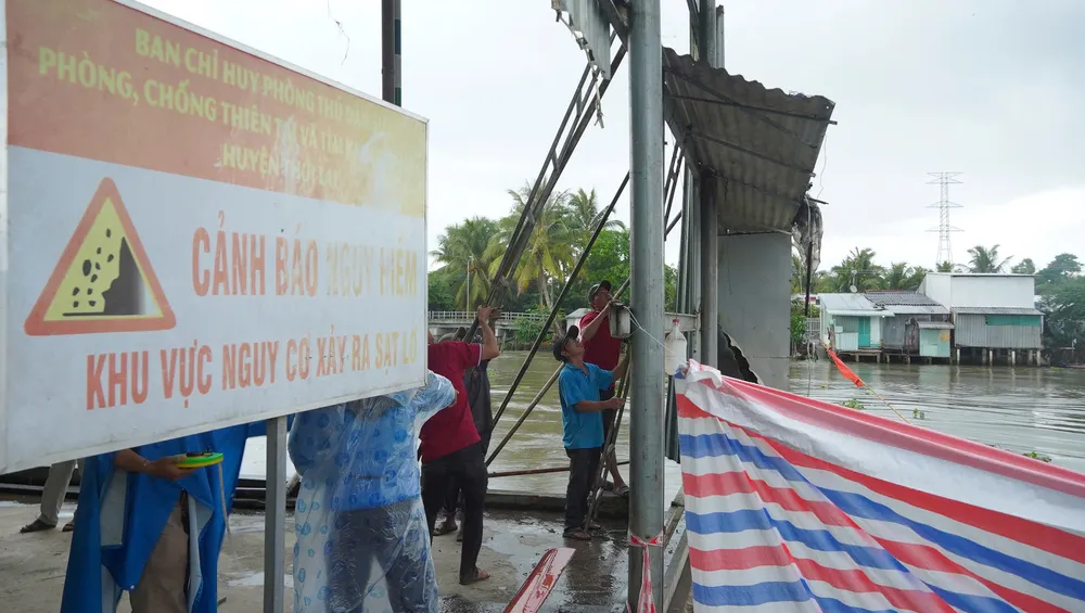
Strong changes in riverbank morphology
According to the Southern Institute of Water Resources Research, the Mekong Delta currently has 743 landslides on river banks and coastlines along a length of 794 km. Of these, there are 686 landslides on river banks along a length of 591 km. The highest number is in Ca Mau with 138 landslides, An Giang with 82 landslides, and Dong Thap with 66 landslides.
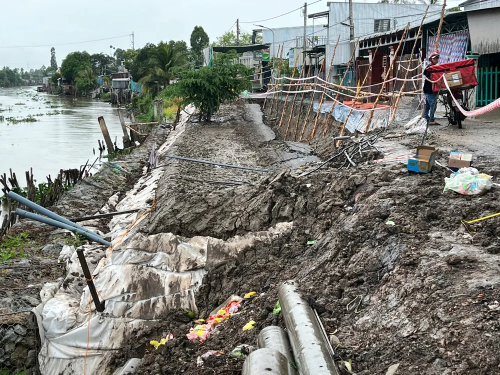
The Southern Institute of Water Resources also pointed out that the river banks and coasts of the Mekong Delta are currently undergoing strong changes in morphology, affecting economic, social and environmental activities. To effectively protect river banks and coasts, it is necessary to consider combining many different solutions, including hard construction solutions, soft solutions, combined solutions and management solutions.
Promote the implementation of re-planning of residential areas along the eroded riverbanks and coastal areas, based on the comparison of relocation and construction costs to make appropriate decisions. For the treatment of riverbank erosion, it is necessary to establish a master plan for the improvement of major rivers and main canals to ensure the combined benefits of related economic sectors. Hard construction solutions and beach nourishment solutions need to have pilot research projects to monitor and evaluate their effectiveness.
Source: https://www.sggp.org.vn/dau-mua-mua-sat-lo-bua-vay-cac-tinh-dbscl-post796576.html





![[Video] The craft of making Dong Ho folk paintings has been inscribed by UNESCO on the List of Crafts in Need of Urgent Safeguarding.](https://vphoto.vietnam.vn/thumb/402x226/vietnam/resource/IMAGE/2025/12/10/1765350246533_tranh-dong-ho-734-jpg.webp)




Comment (0)