
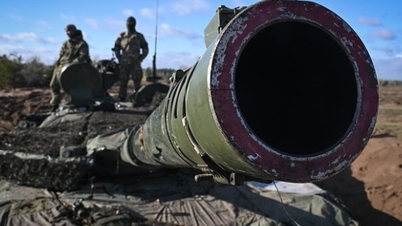
(NLĐO) - Images taken by the US KH-9 (Hexagon) spy satellite system since 1973 have yielded a spectacular archaeological discovery.
According to research recently published in the scientific journal Antiquity, satellite images taken by the US in 1973 have revealed the hidden remains of a 1,400-year-old settlement in what is now Iran.
By comparing it with older documents, an extremely important piece of the puzzle regarding the history of the Middle East has been found.

A satellite image from over half a century ago has revealed a ghost town in what is now Iran - Photo: USGS
According to Live Science , a team of authors led by archaeologist William Deadman from Durham University (UK) deciphered data from this satellite system to study the Hajj pilgrimage route site: Darb Zubaydah.
It is one of the seven important pilgrimage routes on the ancient Arabian Peninsula. The research took place after Saudi Arabia and Iraq jointly nominated the site for consideration as a UNESCO World Heritage site.
The aforementioned ghost town was discovered by chance during a survey. And most surprisingly, details revealed that it was the lost battlefield of the historically significant Battle of al-Qadisiyyah.
The Battle of al-Qadisiyyah took place in 636 or 637 AD between the Arab Muslim army and the Sasanid Empire, which ruled the region that is now Iran from 224-651 AD.
This battle resulted in a crucial victory for the Muslim army and marked the beginning of the Muslim conquest of Persia.
A field survey confirmed this finding. Archaeologists identified a wall nearly 10 km long and a moat north of the ghost town, exactly as described in historical texts.
"This discovery provides the geographical location and context for a battle that was fundamental to the spread of Islam to present-day Iraq, Iran, and elsewhere," said Dr. Deadman.
Source: https://nld.com.vn/giai-mat-ve-tinh-do-tham-thi-tran-ma-1400-tuoi-hien-hinh-196241116101110474.htm


![[Photo] Prime Minister Pham Minh Chinh presides over a meeting on private sector economic development.](/_next/image?url=https%3A%2F%2Fvphoto.vietnam.vn%2Fthumb%2F1200x675%2Fvietnam%2Fresource%2FIMAGE%2F2025%2F12%2F20%2F1766237501876_thiet-ke-chua-co-ten-40-png.webp&w=3840&q=75)

![[Photo] Prime Minister Pham Minh Chinh presides over the conference announcing the establishment of the International Finance Centre in Vietnam.](/_next/image?url=https%3A%2F%2Fvphoto.vietnam.vn%2Fthumb%2F1200x675%2Fvietnam%2Fresource%2FIMAGE%2F2025%2F12%2F21%2F1766309817714_ndo_br_dsc-3400-jpg.webp&w=3840&q=75)


Comment (0)