

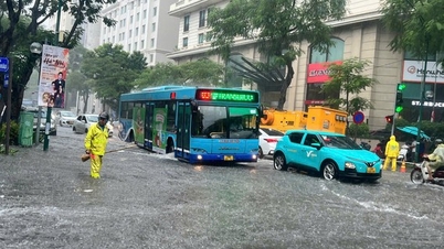
The rain this morning submerged both sides of Le Quang Dao Street in front of My Dinh Stadium. Photo: Phuc Duc
Many streets turned into "seas of water" during rush hour on the morning of September 30.
Due to the impact of storm No. 10 (Bualoi), on the morning of September 30, many central areas of Hanoi experienced heavy rain right at rush hour, causing prolonged traffic congestion and increased risk of flooding on many roads.
Typically, in front of My Dinh Stadium, Le Quang Dao Street in both directions was submerged in "water". Motorbikes and cars moved slowly, many people had to get out and walk, wading through the water in the middle of the crowded traffic. At times, the traffic almost "froze" due to serious congestion.
A similar situation occurred on Trinh Van Bo Street and the Thang Long Boulevard feeder roads (in front of the Vietnam Military History Museum), when deep water flooded the road, making it impossible for vehicles to pass. At the underpasses for people crossing Thang Long Boulevard, the authorities had to put up warning ropes and block vehicles to ensure the safety of road users.
Risk of thunderstorms, tornadoes, lightning and prolonged heavy rain
According to the National Center for Hydro-Meteorological Forecasting, convective clouds are developing strongly in many areas such as Thien Loc, Thuong Cat, Yen Lang, Co Do, Phuc Tho, Hat Mon, Son Dong, An Khanh, Thach That, Chuong My... and expanding into Hanoi's inner city. Between 6am and 9am on September 30, thunderstorms appeared with strong gusts of wind.
Mr. Nguyen Van Huong, Head of Weather Forecasting Department, National Center for Hydro-Meteorological Forecasting, advised people to pay special attention to ensuring safety of life and property, avoid and take shelter in solid places when there are strong thunderstorms. People should regularly update weather forecast information from the Center's website at nchmf.gov.vn or through official media of the Central and local levels.
It is forecasted that in the next 1-4 hours, Hanoi and surrounding areas will continue to have moderate to heavy rain with total rainfall of 30-50 mm, higher in some places. This rain can cause local flooding with a depth of 0.10-0.30 m, even deeper in some low-lying areas; flooding lasts from 20-30 minutes or longer.

Quang Trung Street - Ha Dong (gate of Nguyen Hue School). Photo: VGP/TC
According to the report of Hanoi Drainage Company Limited at 7:00 a.m. on September 30, the impact of storm Bualoi caused scattered light rain from the night of September 29, with rainfall measured at some locations such as Tay Mo 169 mm, Phu Luong 118 mm, Xuan Mai 198 mm. The water level at To Lich River (Hoang Quoc Viet) was recorded at 3.85 m; at Thanh Liet Dam 2.90 m; Lu River 3.01 m; Kim Nguu River 3.01 m.
Some flooding points have appeared at underpass No. 5 and 6 (Km9 - Thang Long Avenue), causing traffic difficulties. The company has arranged forces to be on duty at key points and operated large pumping stations such as Yen So, Cau Buu, Dong Bong 1-2, Co Nhue, Da Sy... to lower the water level. Currently, Yen So pumping station is operating 5/20 units, the sluice gates are operating according to the correct procedures to ensure the safety of the drainage system.

Yen Nghia bus station area. Photo: VGP/TC
According to the Hanoi Department of Construction, with rainfall below 50 mm/h, there are basically no flooded areas in the city. However, with rainfall from 50-70 mm/h, there are about 11 areas prone to flooding, and when rainfall exceeds 100 mm/h, the number of flooded areas can increase by 19.
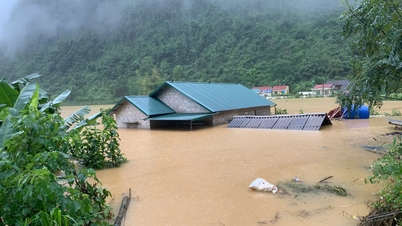
On September 30, Hanoi is forecast to have moderate to very heavy rain and thunderstorms, temperatures of about 24-25°C, humidity of 95%. The rain can cause localized flooding on many streets, affecting traffic and people's daily life. Some suburban areas such as Ba Vi and Son Tay are also at risk of landslides.

Quyet Thang Street, Ha Dong. Photo: VGP/TC
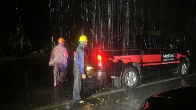
To proactively respond, the Department of Construction has mobilized more than 2,000 personnel and hundreds of equipment from the Hanoi Drainage Company to handle flooding. At the same time, the unit has also developed response scenarios for incidents of falling trees ranging from less than 1,000 to over 10,000 trees.
As of 4 p.m. on September 29, the city had not recorded any major flooding and traffic was still basically smooth. However, storm No. 10 had caused 26 trees to fall and 57 public lighting problems – all of which have now been almost completely resolved.
In addition, the city's technical infrastructure maintenance units have been deployed 24/7, regularly monitoring weather developments and closely coordinating with functional forces to guide and regulate traffic, ensuring safety for people.
As heavy rains may continue, the authorities advise people to proactively update information, limit travel through flooded areas and follow instructions from authorities to ensure safety. People need to continue to closely monitor the weather and prepare appropriate preventive measures.
List of more than 30 flood risk spots in Hanoi on September 30:
• Nguyen Khuyen Street (in front of Ly Thuong Kiet Secondary School gate)
• Hoa Bang Street (from numbers 91 – 97 and 54 – 56)
• Cau Giay – Dich Vong intersection (from 235 – 255 Cau Giay)
• Phan Van Truong Street
• Duong Dinh Nghe – Pham Hung (behind Keangnam building)
• Tran Binh Street (in front of Mai Dich Ward People's Committee - 19/8 Hospital)
• Phan Boi Chau – Ly Thuong Kiet intersection; Duong Thanh – Bat Dan – Nha Hoa intersection
• Tong Dan Street (side gate of Hanoi Party Committee)
• Dinh Tien Hoang Street (fountain, tram station)
• No. 155 Phung Hung
• Cao Ba Quat Street (in front of Hanoi Urban Environment Company)
• Thuy Khue Street (La Pho slope)
• Minh Khai Street (foot of Vinh Tuy Bridge)
• Nguyen Chinh Street (from lane 74 to Tan Mai canal culvert)
• Mac Thi Buoi Street
• Thang Long Avenue (Le Trong Tan intersection, underpass No. 356, An Khanh intersection)
• Do Duc Duc Street
• Ngoc Lam Street (from Long Bien 1 intersection to Gia Lam Urban Environment Enterprise headquarters)
• Hoang Nhu Tiep (from Ngoc Lam Primary School to Hoang Nhu Tiep - Ai Mo intersection)
• Co Linh – Dam Quang Trung Street (section in front of Aeon Mall supermarket)
• Quan Nhan Street
• Cu Loc Street
• Nguyen Trai (before University of Social Sciences and Humanities)
• Nguyen Xien
• Ke Ve Street (Ve Market intersection)
• Ecohome 3
• Resco Urban Area
• National Highway 3 (through Mai Lam commune)
• Road 23B (through Co Dien village)
Thuy Chi
Source: https://baochinhphu.vn/ha-noi-canh-bao-ngap-ung-hon-30-diem-noi-do-103250930111132503.htm

![[Photo] Solemn opening of the 12th Military Party Congress for the 2025-2030 term](https://vphoto.vietnam.vn/thumb/1200x675/vietnam/resource/IMAGE/2025/9/30/2cd383b3130d41a1a4b5ace0d5eb989d)
![[Photo] Panorama of the cable-stayed bridge, the final bottleneck of the Ben Luc-Long Thanh expressway](https://vphoto.vietnam.vn/thumb/1200x675/vietnam/resource/IMAGE/2025/9/30/391fdf21025541d6b2f092e49a17243f)
![[Photo] President Luong Cuong receives President of the Cuban National Assembly Esteban Lazo Hernandez](https://vphoto.vietnam.vn/thumb/1200x675/vietnam/resource/IMAGE/2025/9/30/4d38932911c24f6ea1936252bd5427fa)
![[Photo] The 1st Congress of Phu Tho Provincial Party Committee, term 2025-2030](https://vphoto.vietnam.vn/thumb/1200x675/vietnam/resource/IMAGE/2025/9/30/1507da06216649bba8a1ce6251816820)
![[Photo] General Secretary To Lam, Secretary of the Central Military Commission attends the 12th Party Congress of the Army](https://vphoto.vietnam.vn/thumb/1200x675/vietnam/resource/IMAGE/2025/9/30/9b63aaa37ddb472ead84e3870a8ae825)


Comment (0)