According to the National Center for Meteorological and Hydrological Forecasting, satellite images and weather radar showed that convective clouds continued to develop this afternoon (September 11), causing rain in Hanoi .
Strong convective clouds from Bac Ninh and Hung Yen are also moving towards the capital, forecast to bring showers and thunderstorms this afternoon and early evening. There is a risk of tornadoes, lightning, and strong gusts of wind during the thunderstorms.
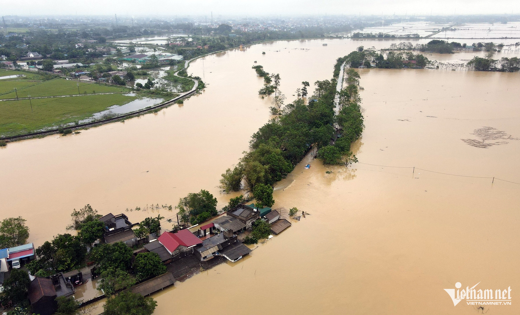
The water level of the Red River in Hanoi is forecast to peak at noon today, exceeding alarm level 2 by about 30cm, reaching 10.8m, causing severe flooding in riverside areas this afternoon due to the high water levels. Meanwhile, the flood on the Thai Binh River continues to rise and may peak tomorrow.
Over the next 12 to 24 hours, flood levels on the Red River in Hanoi will recede slowly and remain below alarm level 2 in the Long Bien area.
On the morning of September 11th, the People's Committee of Bac Tu Liem district announced that it had relocated 836 households outside the Red River dike in 4 wards to safe areas.


Tay Ho District is relocating 214 households in Alley 76 An Duong. Hoan Kiem District is moving 46 households along the Red River to higher ground.
Ung Hoa district provided assistance to 110 households to avoid flooding from the Day River, while Dong Anh district relocated 231 households to temporary shelters at community centers and medical facilities.
In Dan Phuong district, 66 households were relocated, while in Thach That district, 192 households were affected by the flooding of the Tich River, but no relocation was necessary because the residents proactively took preventative measures.
Many areas in Northern Vietnam experienced heavy rainfall.
Last night and this morning, moderate to heavy rain and scattered thunderstorms occurred in the plains, northeastern part of Northern Vietnam, Hoa Binh, and North Central Vietnam, with very heavy rain in some areas. The Viet Bac region of Northern Vietnam experienced scattered showers and thunderstorms, with heavy rain in some localized areas. Rainfall amounts from 7 PM on September 10th to 8 AM on September 11th exceeded 100mm in some places, such as: Ba Sao (Ha Nam) 111.8mm, Que Vo (Bac Ninh) 109.6mm, Cao Son (Hoa Binh) 103.6mm, Yen Tinh (Nghe An) 130.4mm, Cam Yen (Ha Tinh) 106.4mm, etc.
On September 11th, both day and night, the plains and northeastern areas of Northern Vietnam, Hoa Binh, Thanh Hoa, and Nghe An experienced moderate to heavy rain and thunderstorms, with some areas experiencing very heavy rain. Rainfall amounts generally ranged from 30-70mm, with some areas receiving over 150mm.
Additionally, on September 11th, both day and night, scattered showers and thunderstorms are expected in the Viet Bac region of Northern Vietnam, from Ha Tinh to Thua Thien Hue, with localized heavy rain in some areas, with rainfall amounts ranging from 15-30mm, and in some places exceeding 80mm.


On the afternoon and evening of September 11th, scattered showers and thunderstorms are expected in the area from Da Nang to Binh Thuan, with localized heavy rain; the Central Highlands and Southern Vietnam will experience showers and thunderstorms, with localized heavy rain in some areas, with rainfall amounts ranging from 10-30mm, and in some places exceeding 60mm. During thunderstorms, there is a possibility of tornadoes, lightning, and strong gusts of wind.
On September 12th, both day and night, scattered showers and thunderstorms are expected in the Northern Delta, Central, Central Highlands, and Southern regions of Vietnam, with some areas experiencing heavy rain.
Source: https://vietnamnet.vn/nhieu-diem-o-ha-noi-mua-to-keo-dai-nhieu-gio-2320920.html
![[Photo] Prime Minister Le Minh Hung presides over the thematic session on promoting science and technology development and innovation.](https://vphoto.vietnam.vn/thumb/1200x675/vietnam/resource/IMAGE/2026/06/23/1782207872934_ndo_br_dsc-1724-jpg.webp)