
Updated position of super typhoon No. 9 Ragasa at 5:00 a.m. on September 24. Source: Vietnam Disaster Monitoring System
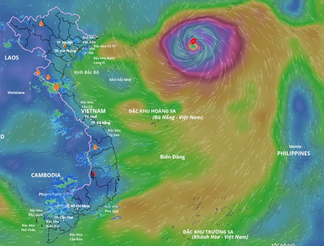
Latest update from the National Center for Hydro-Meteorological Forecasting, at 4:00 a.m. on September 24, the center of super storm No. 9 Ragasa was at about 21.3 degrees north latitude; 114.3 degrees east longitude, in the northern sea area of the North East Sea, about 650km east of Mong Cai ( Quang Ninh ).
The strongest wind near the center of the super storm is level 15-16 (167-201km/h), gusting over level 17. Moving west-northwest at a speed of about 20km/h.
It is forecasted that in the next 24 hours, the super storm will move west-northwest at a speed of 20-25km/hour and gradually weaken.
At 4:00 a.m. on September 25, the center of the storm was at about 21.6 degrees north latitude; 109.5 degrees east longitude, on the coastal area of Guangxi province (China), about 150km east of Mong Cai (Quang Ninh). Intensity level 11, gust level 13.
The danger zone is north of latitude 18.5 degrees north, west of longitude 118 degrees east. The disaster risk level is level 4 for the sea area north of the North East Sea; level 3 for the area north of the Gulf of Tonkin and the Northeast.
It is forecast that in the next 48 hours, the storm will move west at a speed of 25-30km/hour, weaken into a tropical depression, then into a low pressure area.
At 4:00 a.m. on September 26, the center was at about 21.3 degrees north latitude; 103.8 degrees east longitude, on the mainland of the Northwest region. Intensity below level 6.
The danger zone is north of latitude 19.5 degrees north, west of longitude 111.5 degrees east. The disaster risk level is level 3 for the northwest sea area of the northern East Sea, the northern Gulf of Tonkin and the Northeast.
Regarding the impact of the storm at sea, the northern sea area of the North East Sea has strong winds of level 10-13, the area near the center of the super storm has winds of level 14-16, gusts above level 17, waves over 10m high, and very rough seas.
From noon on September 24, the sea area east of the northern Gulf of Tonkin (including Bach Long Vi special zone) will have winds gradually increasing to level 6 - 7, gusting to level 9.
From the night of September 24, the northern area of Bac Bo Gulf (including Bach Long Vy, Van Don, Co To, Cat Hai and Hon Dau Island) will have winds gradually increasing to level 8, waves 2-4m high, areas near the storm center will have winds of level 9-11, gusts of level 13, waves 3-5m high, and very rough seas.
Storm surge in coastal areas in Quang Ninh province has storm surge height of 0.4-0.6m. High risk of landslides, sea dykes, destruction of aquaculture areas, boats anchored along the coast due to strong winds, rising sea levels and big waves.
On land, from early morning on September 25, coastal areas from Quang Ninh to Ninh Binh will have winds gradually increasing to level 6-7, near the storm center level 8-9, gusting to level 11; inland areas in the northeast region, winds will be strong at level 5, in some places level 6, gusting to level 7-8.
Regarding heavy rain, from the night of September 24 to the end of the night of September 26, in the northern region, Thanh Hoa and Nghe An, there will be heavy to very heavy rain with common rainfall of 100-250mm, locally over 400mm. Beware of heavy rain causing urban flooding. Heavy rain is likely to cause flooding in low-lying areas, flash floods on small rivers and streams, and landslides on steep slopes.
Due to the influence of the wide storm circulation, it is necessary to guard against the risk of thunderstorms, tornadoes and strong gusts of wind both before and during the storm's landfall.
Laodong.vn
Source: https://laodong.vn/moi-truong/sieu-bao-so-9-ragasa-di-nhanh-giat-tren-cap-17-con-cach-quang-ninh-650km-1579664.ldo

![[Photo] Prime Minister Pham Minh Chinh attends the groundbreaking ceremony of two key projects in Hai Phong city](https://vphoto.vietnam.vn/thumb/1200x675/vietnam/resource/IMAGE/2025/9/27/6adba56d5d94403093a074ac6496ec9d)


Comment (0)