
Ham Tan District was established in 1916 in Binh Thuan Province. Prior to that, the area of Ham Tan belonged to Duc Thang commune, Tuy Dinh district, then Tuy Ly district, Ham Thuan prefecture. La Gi/Ham Tan and later became the administrative center of Binh Tuy province (1956 - 1976).
From ancient Tuy Ly to place names from the time of land reclamation.
The place name La Di/La Gi appeared in the mid-19th century, approximately 200 years ago. According to the book Dai Nam Nhat Thong Chi (volume 12), in the 13th year of Minh Mang (1832), Tuy Dinh district was established under Ham Thuan prefecture. In the 7th year of Tu Duc (1854), Tuy Dinh was changed to Tuy Ly district, belonging to the provincial administration. In the 13th year (1901), two communes, Cam Thang and Ngan Chu, were transferred to Tanh Linh district. This area was adjacent to the wild highlands in the northwest of Binh Thuan province, initially under the jurisdiction of Tuy Phong district. In the 13th year of Thanh Thai (1901), Di Dinh Tho Phu (the place name Di Linh or Di Dinh/Djiring) was established with 20 books of the highland people, and the Di Linh administrative division was established under the Binh Thuan Commissioner. The Dong Nai Thuong province was established in 1899 and abolished in 1903, and Di Linh became an administrative division still belonging to Binh Thuan. By 1920, Lam Vien province was abolished, and Dong Nai Thuong province was re-established, with its capital in Di Linh. At that time, Da Lat had not yet been developed into a resort city.
By 1910, the administrative organization of Binh Thuan province was divided into 3 prefectures: Ham Thuan, Phan Ly (Cham), and Di Linh, and 5 districts: Hoa Da (Kinh), Tuy Phong, Tuy Ly (Cham), Tanh Linh, and Tuc Trang/Trung. From 1910 onwards, the administrative organization of prefectures and districts was at the same level. Ham Tan district was established in 1916, extracted from the land that formed Lam Vien province, and Binh Thuan had 4 prefectures - Ham Thuan, Tuy Phong, Hoa Da, and Ham Tan (Decree of Duy Tan approved by the Governor-General of Indochina on May 3, 1916 - establishing Central Vietnam, separating one province, Lam Vien (excerpt from *Changes in the Administrative Geography of Central Vietnam* - Historical Studies No. 143-1972).
Under the Republic of Vietnam regime, President Ngo Dinh Diem signed Decree No. 143 on October 26, 1956, establishing Binh Tuy province, comprising three districts (Ham Tan, Hoai Duc, and Tanh Linh) from two districts of Ham Thuan (Binh Thuan province) and parts of Long Khanh and Lam Dong provinces. Geographically, Binh Tuy province is located in the southernmost part of Central Vietnam and the northernmost part of Southern Vietnam, adjacent to the easternmost region of the Central Highlands.
Binh Tuy - La Gi - Ham Tan
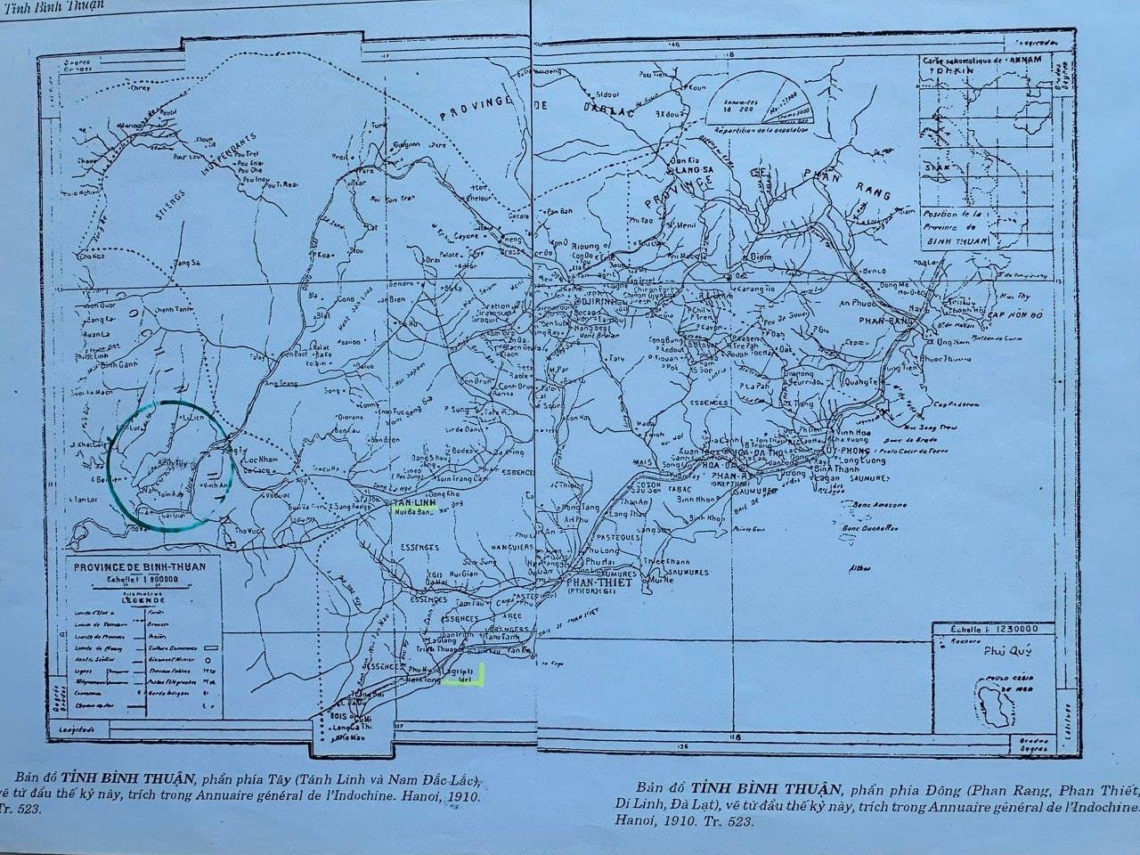
Regarding the place name Binh Tuy, the name Binh Tuy district appeared in the 19th year of Minh Mang (1838). According to the book "Nam Ky Dia Hat Tong Thon…" (1892) translated and annotated by Nguyen Dinh Tu in the Bien Hoa district section, Binh Tuy district had 7 villages and the neighboring Phuoc Thanh district, some of which bore place names in present-day Duc Linh (Gia An, Tra Tan, Do Dat/Vo Dat and nearby Dinh Quan/Quan, Tuc Trung/Trang…). On the map of Binh Thuan province - the eastern part (Phan Rang, Phan Thiet, Di Linh, Da Lat) drawn from the beginning of this century, quoted in Annuaire général de l'Indochine Hanoi, 1910 - p. 523. The history of the southwestern part of Binh Thuan province bordering Dong Nai and Lam Dong provinces also includes parts located deep within Long Khanh province, separated from Bien Hoa province (established in the same year as Binh Tuy and Phuoc Tuy provinces). This area became a base of operations called Giao Loan/Rung La under the Nguyen Dynasty (1802-1861). During the war against the US, Binh Tuy province belonged to the territory of the III Corps - 3rd Tactical Zone of the Republic of Vietnam Armed Forces, comprising 10 provinces: Bien Hoa, Phuoc Tuy, Binh Tuy, Long Khanh, Phuoc Long, Binh Long, Binh Duong, Tay Ninh, Hau Nghia, and Long An. However, Binh Thuan province at that time belonged to the II Tactical Zone. Under the leadership of the Regional Party Committee and the Command of Military Region VI, directly under the Central Committee of the Southern Region, it held a strategic position and a revolutionary movement, especially in the southernmost coastal area of Central Vietnam and the southern Central Highlands. Historically, the land of the former Tuy Ly district occupied a large area in the south. During the war, this area held strategic importance for the southeastern region. But in peacetime, it also possesses rich natural potential, including fertile soil and a mild climate favorable for development. In the past, Ham Tan District used the Dinh River as the boundary between Phong Dien and Phuoc Thang communes. The boundaries of Ham Tan District were mainly based on the inhabitants living along the coast, from Van Ke and Cua Can down to Thang Hai… The district's administrative center was located in Ham Tan village, which is now Phuoc Hoi ward. Phuoc Loc village was home to fishermen from Central Vietnam, but after the French conquest of the six southern provinces in 1865, many waves of migrants left from there. Perhaps due to cultural exchange and influence, several neighboring villages in Ba Ria - Vung Tau have place names beginning with the word "Phuoc" (福) (Phuoc Buu, Phuoc Thang, Phuoc Tinh, Phuoc Tuy, Phuoc Hai, Phuoc Le…), and the Thuan Phuoc post station was a stop in Phuoc Loc village (La Gi), marking the arrival of southern migrants in Binh Thuan province. During the Nguyen Dynasty, the main road from Phan Thiet to Bien Hoa - Saigon also followed the coast, passing through the post stations of Thuan Ly/Thuan Lam (near Thanh My village), Thuan Trinh (Tam Tan), Thuan Phuoc (Phuoc Loc), Thuan Phuong (Thang Hai), Thuan Bien bordering Xuyen Moc (later Moc Xuyen - belonging to Bien Hoa)... In 1890, when the first colonial road (National Highway 1A) was opened through Binh Thuan, this coastal section of the main road was abandoned. The waterway along the coast from Khe Ga Cape to Ba Cape (Xuyen Moc) is approximately 80 km.
Throughout history, La Gi has been a central hub for commercial and administrative activities, all taking place in the Phước Hội and Phước Lộc areas, which the locals traditionally called La Gi. The name Dinh River has appeared on many maps, but the Đại Nam nhất thống chí (volume 12 - Bình Thuận) records the river as La Di, "flowing into the La Di estuary."
During the period of feudal rule and French colonial rule (1916-1945), the La Gi - Ham Tan area, although a district capital, remained a remote southern region of Binh Thuan province. Nearly 40 years passed with nine district chiefs, the last being Ho Dinh Lan. At that time, Ham Tan was only populated by scattered residents in the villages of Tan Ly, Tan Long, Phuoc Loc, Ham Tan, and further afield in Van Ke, Phong Dien, Tam Tan, Pho Tri, Thang Hai… But in early 1946, the French recaptured Ham Tan, establishing garrisons in La Gi, Tan Ly, Tam Tan… and the people of Ham Tan and La Gi evacuated into the deep forests, beginning a protracted resistance war. By 1949, when the French withdrew to Phan Thiet, Ham Tan/La Gi completely became a base area in the south of the province until the implementation of the Geneva Accords in 1954, ending the war.
New place names on old land.
When the Ngo Dinh Diem government established Binh Tuy province, with its capital in La Gi, a town gradually began to take shape. The main road ran from the fish market along the right bank of the Dinh River to the present-day Tan Ly bridge (now Cong Hoa Street - now Le Loi Street). The Old Market area opened, with many of the first businesses, and later the New Market area was built. Most were people originally from La Gi who had migrated to Phan Thiet, along with some Chinese people married to Vietnamese people who returned. The shops were mainly general stores, traditional medicine shops, tailor shops, noodle shops, etc. A significant portion of the population relied on fishing, creating a strong attraction due to the abundant seafood resources of the region.
The La Gi market (the site of the current La Gi/Phuoc Hoi market) was the earliest built in this area at that time. The first provincial administrative office was located on the land on the right bank of the Dinh River (later the former Seafood Company), next to a hospital with about 50 beds. The various departments were located nearby on the land of Phuoc Hoi ward. The current 4 km Thong Nhat road (Su road) resembled a carrying pole, with two ends being the production and commercial area and the other end being the administrative offices, hospital, high school, etc. The government apparatus moved to this administrative area, but it wasn't until 1958-1960 that the various departments, the Construction Bureau, the Mediation Court, the Post Office, the Park, the Administrative Building, the Sub-district, etc., were built in the "New Province" (as it was called then). The Da Dung dam was also completed, providing water for the Tan Ly and Phuoc Thien (Tan Thien) rice fields and also serving as a source of drinking water for the provincial capital.
There will come a time when few can imagine what the town of La Gi looks like today, considering how much it has changed and transformed over the more than a century since the founding of Ham Tan district. Most of the place names from the early days of settlement, even in the heart of La Gi, were based on natural features and were purely Vietnamese. These names have gradually disappeared since the swampy area was liberated from the resistance against the French and became the provincial capital of Binh Tuy under the old regime in 1956. However, Binh Tuy province extended to the southwest, encompassing Hoai Duc and Tanh Linh districts. The place name Lang Gang – a cemetery on the edge of the forest (now a stadium) – and Duong Su (a historical road) dating back to around 1890, connecting the Truong Tien intersection (National Highway 1A) with La Gi, are still relevant. The current Thong Nhat road is the final section of this road. At the roundabout in Nguyen Hue Park, there was a place called Lang Cat, and nearby were places like Bung Can Cau, Xom Ray, Bung Ngang, Suoi Dua, Bau Ong, Gieng Thay, Lang Da… The fields and plantations bordering the forest from that time have been replaced by the names of wards and neighborhoods. A small stream branching off from the Dinh River, about a hundred meters from Tan Ly Bridge, flows through a flooded pond and reeds/sedges (Giang Da hamlet - neighborhood 10 - Phuoc Hoi), meandering along the side of Quang Duc Pagoda before joining the Dinh River. The new neighborhood on 23/4 Street sprang up on reclaimed land from a swampy area overgrown with mangrove trees and bamboo groves next to a large plot of land belonging to Mr. Tong Doan. Next to it is the district's football field, where the historic rally to establish the 1945 Revolutionary government took place.
Even more impressive, for La Gi, a type 3 urban area, now celebrating its 20th anniversary since its establishment (2005-2025), the construction projects and streets, within a peaceful living environment, have rapidly transformed its appearance, befitting a commercial, service, and tourism hub.
(*) - References from: Dai Nam Nhat Thong Chi (Volume 12) - Publishing House of Culture - Ministry of Culture and Education/Republic of Vietnam 1965; Southern Vietnam District General Villages (Ho Chi Minh City General Publishing House 2017); Research on Land Registers of the Nguyen Dynasty - Binh Thuan - 1966; Dong Nai Gazetteer 2001; Binh Tuy Local Gazetteer (January 1975)...
Source: https://baobinhthuan.com.vn/tim-lai-dia-danh-vung-dat-tay-nam-binh-thuan-129881.html


Comment (0)