
TPO - Entering the dry season of 2025, Ho Chi Minh City and the provinces and cities in the Southwest region are being affected by saltwater intrusion, the salinity level in Ho Chi Minh City is the most serious since 2019.
TPO - Entering the dry season of 2025, Ho Chi Minh City and the provinces and cities in the Southwest region are being affected by saltwater intrusion, the salinity level in Ho Chi Minh City is the most serious since 2019.
According to the Southern Hydrometeorological Station, monitoring data at measuring stations in Ho Chi Minh City showed that the salinity recorded in the first phase of February 2025 was higher than the salinity recorded in the same period in the last 5 years. The highest salinity value recorded in the first phase of February 2025 (February 11-12, 2025 - low tide) was 11.13‰ at Mui Nha Be station.
Specifically, the highest salinity recorded in February in the last 5 years at Mui Nha Be station is as follows: 8.95‰ in 2019; 10.79‰ in 2021; 9.2‰ in 2022; 9.7‰ in 2024.
Compared to the same period in 2024, the highest salinity recorded in early February 2025 increased by 1.43‰; higher than in 2021 (10.79‰), which was the year with the second most severe salinity intrusion in this period.
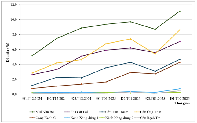 |
Highest salinity levels on rivers and canals in Ho Chi Minh City from late 2024 to early February 2025. Source: Southern Hydrometeorological Station |
From December 2024 to early February 2025, saline intrusion in rivers and canals in Ho Chi Minh City tends to increase. Salinity begins to increase from December 2024, with a maximum value of up to 11.13‰.
Forecast of typical salinity values at stations in Ho Chi Minh City in mid-February 2025 as follows:
The location of Mui Nha Be often clearly shows the change in salinity concentration during the day. The forecasted salinity in mid-February 2025 here reaches the highest salinity value of 11.05‰. The highest salinity at Thu Thiem bridge (Saigon river) is about 4.64‰, at Cat Lai ferry is 7.09‰, Ong Thin bridge is 7.09‰.
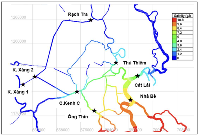 |
Forecast map of salinity at 7am, February 16, 2025 on rivers and canals in Ho Chi Minh City. Source: Southern Hydrometeorological Station |
“The saline intrusion situation is quite complicated, affecting riverside areas such as Nha Be Cape, Cat Lai Ferry, Thu Thiem Bridge and Ong Thin Bridge. The high saline intrusion trend requires close monitoring in the coming time to promptly come up with solutions to ensure water sources for daily life and production” - The Southern Hydrometeorological Station recommends.
Meanwhile, forecasting the salinity intrusion situation in the Southern region, the National Center for Hydro-Meteorological Forecasting said that the water level on the Mekong mainstream is changing slowly and is generally lower than the average of many years. The water level on the Tien and Hau rivers fluctuates with the tide. The highest water level of the week in Tan Chau is 1.55m, in Chau Doc is 1.75m, 0.2-0.3m higher than the average of the same period.
From February 11 to 20, the water level at Vung Tau station fluctuated at a high level and tended to decrease gradually. The peak tide during this period fluctuated between 390 - 400cm, the peak tide time mainly occurred between 0:00 and 3:00 and 14:00 and 17:00 every day.
 |
The tide level in the West Sea (Rach Gia station) from February 11 to 20 fluctuated at a high level and tended to decrease gradually. The peak tide during this period fluctuated between 55 - 60cm, appearing between 3 and 6 hours every day.
According to the National Center for Hydro-Meteorological Forecasting, saltwater intrusion trend from February 11 to 20: Saltwater intrusion in the Mekong Delta increased until February 16, then gradually decreased.
The highest salinity at the stations is lower than the highest salinity in February 2024, with some stations in Ca Mau having higher salinity. The depth of the 4‰ salinity boundary at the main river mouths: Dong Vam Co River, Tay Vam Co River (salinity intrusion range 45-55km); Cua Tieu River, Dai Cua River (salinity intrusion range 40-45km); Ham Luong River (salinity intrusion range 45-55km); Co Chien River (salinity intrusion range 45-55km); Hau River (salinity intrusion range 45-55km); Cai Lon River (salinity intrusion range 30-40km).
The forecast of saline intrusion in the Mekong Delta in the 2024-2025 dry season is higher than the average of many years but not as severe as the 2015-2016 and 2019-2020 dry seasons.
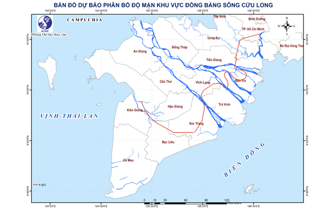 |
Map predicts the distribution of the highest salinity from February 11-20, 2025 in the Mekong Delta region. |
Increased saline intrusion in the Mekong Delta is likely to occur in February - March 2025 (from February 10 - 16; February 27 - March 4); in the Vam Co and Cai Lon rivers in March - April 2025 (from March 10 - 15; March 29 - April 2; April 27 - May 1). The saline intrusion situation in the Mekong Delta depends on water sources from the upper Mekong River, high tides and will fluctuate in the coming time.


Source: https://tienphong.vn/xam-nhap-man-tai-tphcm-nghiem-trong-nhat-trong-5-nam-qua-post1717447.tpo


![[Photo] General Secretary To Lam attends the launch of 3 digital platforms serving the implementation of Resolution No. 57-NQ/TW](https://vphoto.vietnam.vn/thumb/402x226/vietnam/resource/IMAGE/2025/7/2/d7fb7a42b2c74ffbb1da1124c24d41d3)


Comment (0)