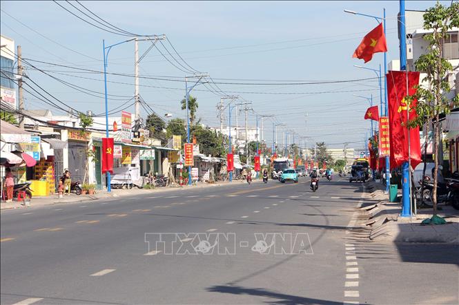
A section of the Ring Road in An Binh ward (Ninh Kieu district), a road that played a crucial military role during the two wars of national liberation. (Photo: Trung Kien/TTXVN)
A place where "bullets meet bullets, bombs sit next to bomb craters."
The Ring Road originates from the foot of Cai Rang Bridge (Ninh Kieu District), runs through Phong Dien District, and ends at Lo Te Ba Se (O Mon District), spanning approximately 30km. This is a convenient transportation route with a strategically important location at the southwestern gateway to the center of Can Tho City.
According to data from the History of the Phong Dien Party Committee (2004-2024), given the strategic importance of the Ring Road, the US-puppet regime established a dense network of military outposts along the entire route, viewing the Ring Road as a protective belt for Tra Noc Airport, the IV Tactical Zone Center, and US-puppet regime representative offices in Can Tho. Meanwhile, the Ring Road was considered a troop transfer point, a forward medical station, and a weapons storage location providing logistical support for our army units.
According to Colonel Huynh Thanh Phuong, Chairman of the Can Tho City Veterans Association, due to its importance, the Ring Road witnessed fierce battles between our forces and the enemy. The enemy concentrated on sweeping through the civilian population, hunting down and capturing our forces; they frequently shelled and bombed the area in an attempt to turn it into a "white zone," pushing the revolutionary forces away from the people.
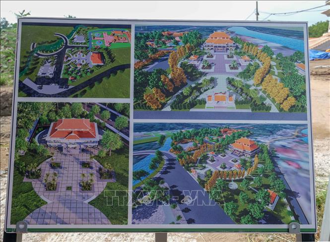
Perspective view of the project to preserve, restore, and promote the value of the Lo Vong Cung historical site after completion. Photo: Thanh Liem/TTXVN.
In the memories of many veteran revolutionaries, from 1968 until liberation, the Ring Road endured hundreds of thousands of tons of bombs and ammunition, leaving the vegetation devastated. The poet Lam Thao once described this area as "bullets piled upon bullets, bombs next to bomb craters," to illustrate the brutal nature of this land.
Despite fierce fighting and the enemy's cruel tactics to destroy and isolate the people from the resistance zone, cutting off communication between the people and the revolution, the soldiers were still able to live among the people. The army and people steadfastly held their ground, fighting to maintain the revolutionary base area of Lo Vong Cung as a springboard for the attack to liberate Can Tho in 1975.
After liberation, the government and people of Lo Vong Cung overcame difficulties, united, and worked hard to rebuild the desolate, bomb-ravaged land into a "green belt." Fifty years have passed, but the memories of that time remain vivid in the mind of former patriotic prisoner Nguyen Van Xa (80 years old, former commune militia leader and Chairman of Giai Xuan commune from 1969 to 1978): From 1971, displaced people began returning home. But it wasn't until after 1975 that Lo Vong Cung truly came alive, with vegetable gardens and rice fields covered in green... Although life was still difficult, the government, officials, and people were determined to revive this "blank land."
Greening the "Ring of Fire"
My Khanh tourist village in Phong Dien district is a popular choice for many tourists during holidays. (Photo: Thu Hien/TTXVN)
Most of the area of the present-day Ring Road is located in Phong Dien District. The Ring Road stretches approximately 15km through Phong Dien District. Phong Dien District is identified by Can Tho City as the "green lung" and a key area of the city. In recent years, leveraging its fertile soil and abundant fruit orchards, Phong Dien has actively promoted economic restructuring; prioritizing high-quality ecological agriculture and ecotourism services; and developing distinctive tourism products to attract tourists.
The Ring Road now has a new administrative name, Provincial Road 923, and is associated with famous landmarks in the Western region such as: Cai Rang Floating Market, My Khanh eco-tourism area, and the fruit orchards of Truong Long, Nhon Ai, and Tan Thoi (Phong Dien district)...
From Provincial Road 923, there are many branch roads leading to cultural relic sites such as: the national cultural relic of Phan Van Tri's tomb, the Ong Hao historical and cultural relic site, the Monument of Hatred in Tan Thoi commune, the Lung Cot Cau floating rock cultural relic site, and the Vam Gura tourist area (Nhon Nghia commune)...
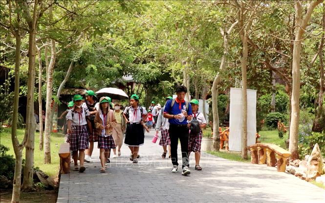
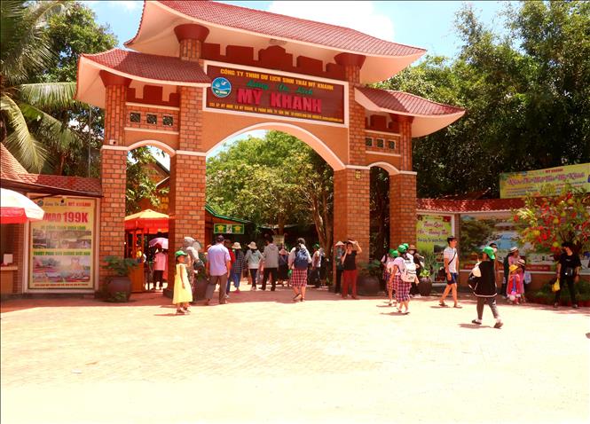
With its ecotourism features and cool, shady orchards, My Khanh Tourist Village in Phong Dien district is a popular choice for tourists during holidays. Photo: Thu Hien/TTXVN
When mentioning tourism in Phong Dien, one must mention My Khanh Tourist Village (My Khanh commune). My Khanh Tourist Village has been established and developed for over 20 years. From a tourist village of about 1 hectare, it has now expanded to over 30 hectares, including functional areas serving tourism; among them, there is an entertainment area (pig racing, dog racing, etc.), a traditional craft village with artisans making folk cakes for visitors, rest areas, fruit orchards, etc.
My Khanh Tourist Village is ranked as the first 4-star OCOP product of Can Tho in particular and the entire Mekong Delta region in general. Every year, the My Khanh eco-tourism area welcomes tens of thousands of domestic and international tourists to visit, experience the culture, cuisine, and beautiful scenery of the Western Mekong Delta.
Phong Dien is also known as the "fruit kingdom" in Can Tho. The district has developed specialized farming areas for durian (Tan Thoi commune), star apple (Giai Xuan, Truong Long), longan (Nhon Nghia), etc.
According to Mr. Nguyen Trung Nghia, Secretary of the Phong Dien District Party Committee, the "ring of fire" - the Ring Road during the years of bombing - is gradually transforming into a "green belt" with over 9,000 hectares of orchards and 65 tourist destinations. In 2024, tourist destinations in the district attracted nearly 2 million visitors, generating revenue of over 532 billion VND.
Phong Dien is aiming to become an ecological urban area, developing harmoniously between urban and rural areas, ensuring it serves as the "green lung" of Can Tho city.
Phong Dien District was recognized by the Prime Minister as a district meeting the standards of a new rural area in 2015. To date, all six communes in the district have been recognized as meeting the standards of an advanced new rural area; of which, four communes have been recognized as model new rural areas. The district is currently focusing on implementing the criteria for building an advanced new rural district.
Located on the Ring Road, Tan Thoi commune was recently recognized as a model new rural commune in 2024. According to Ms. Nguyen Ho Phuong Thao, Chairwoman of the Tan Thoi Commune People's Committee, the commune's strength lies in developing its orchard economy. The commune currently has 1,270 hectares of fruit orchards; of which, 1,249 hectares are planted with durian, yielding over 15,000 tons annually. The commune has 17 durian growing area codes granted for export. The people's lives are prosperous, and the commune has had no poor households since 2023.
Fifty years after liberation, Phong Dien district has entered a new chapter in its development. The district's economic growth rate has consistently remained high, and its economic structure has shifted in the right direction.
According to Tran Le Binh, Permanent Deputy Secretary of the Phong Dien District Party Committee, the district's socio-economic infrastructure system is being gradually built in a synchronous and modern manner. Urban beautification is being given attention, and the urban landscape has changed significantly. In particular, among the 8 key projects of Can Tho City (2021-2026 term), there are 2 major projects creating new momentum and breakthroughs related to the Ring Road: the Western Ring Road project connecting National Highway 91 with National Highway 61C, passing through 5 districts (O Mon, Binh Thuy, Ninh Kieu, Cai Rang, and Phong Dien); and the project to upgrade and renovate Provincial Road 923, over 13km long (starting from Phong Dien town to Truong Lac ward, O Mon district), with a total investment of over 570 billion VND.
Fifty years after the Liberation of Southern Vietnam and the reunification of the country, the "Fire-Burning Arc" has left its mark on the glorious history of the nation. Now, a prosperous life is unfolding in this heroic land. A land once ravaged and battered by bombs and bullets has transformed into an eco-tourism area, a kingdom of famous fruit trees in the Western region. The "Fire-Burning Arc" has truly been greened.
Source: https://baotintuc.vn/thoi-su/50-nam-thong-nhat-dat-nuoc-dat-lua-no-hoa-20250329071105775.htm


![[Photo] The courage of new recruits of Brigade 144 on the training ground.](https://vphoto.vietnam.vn/thumb/1200x675/vietnam/resource/IMAGE/2026/05/27/1779881651341_anh-man-hinh-2026-05-27-luc-18-32-52.png)

![[Photo] The heat at the fireworks display site on the opening night of the Da Nang International Fireworks Festival 2026](https://vphoto.vietnam.vn/thumb/1200x675/vietnam/resource/IMAGE/2026/05/27/1779889741485_ndo_br_z7872039145157-fecaba5112f39e8352544099d7ef4738-5140-jpg.webp)


![[Photo] The courage of new recruits of Brigade 144 on the training ground.](https://vphoto.vietnam.vn/thumb/402x226/vietnam/resource/IMAGE/2026/05/27/1779881651341_anh-man-hinh-2026-05-27-luc-18-32-52.png)


Comment (0)