
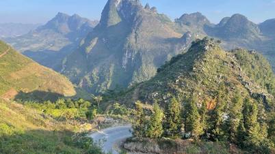
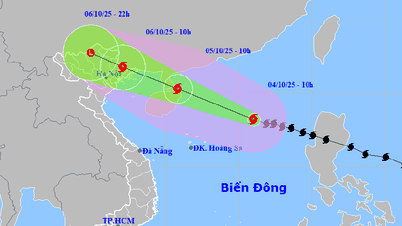
On the morning of August 18, the Department of Hydrometeorology said that a tropical depression had entered and was operating in the Gulf of Tonkin with strong winds of level 6-7, gusting to level 9, causing dangerous weather at sea and heavy rain on land (coastal areas of North Central and Northern Vietnam).
At 10:00 a.m. on August 18, the center of the tropical depression was at about 19.2 degrees North latitude - 108.2 degrees East longitude, about 115km South-Southeast of Bach Long Vi Island. The strongest wind near the center reached level 6-7, gusting to level 9. This system moved in a North-Northwest direction at a speed of 15km/hour.

In the next 36 hours, the tropical depression will continue to move northwest at a speed of 10-15 km/hour. Meteorological experts predict that the tropical depression will enter the Vietnam-China border area on the morning of August 19, with winds of level 6, gusting to level 8.
By the evening of August 19, the low pressure will weaken into a low pressure area over mainland Guangxi (China).
At sea, the Gulf of Tonkin will have strong winds of level 6-7, gusts of level 9, waves of 2-3.5m high, and rough seas. Ships passing through the dangerous area are at risk of being affected by thunderstorms, tornadoes, strong winds, and large waves. On land, from this afternoon, August 18, the coast of Quang Ninh - Hai Phong will have strong winds of level 6, gusts of level 8.

Regarding rain, from August 18 to the night of August 19, the Northeast and Thanh Hoa will have moderate rain, heavy rain and thunderstorms, some places will have very heavy rain with rainfall of 50-150mm, locally over 300mm. In Nghe An and Ha Tinh , during the day and tonight, August 18, there will be moderate to heavy rain, some places over 150mm.
Source: https://www.sggp.org.vn/ap-thap-nhiet-doi-huong-ve-bien-gioi-viet-nam-trung-quoc-post808928.html

![[Photo] Bustling Mid-Autumn Festival at the Museum of Ethnology](https://vphoto.vietnam.vn/thumb/1200x675/vietnam/resource/IMAGE/2025/10/4/da8d5927734d4ca58e3eced14bc435a3)


![[Photo] Solemn opening of the 8th Congress of the Central Public Security Party Committee, term 2025-2030](https://vphoto.vietnam.vn/thumb/1200x675/vietnam/resource/IMAGE/2025/10/4/f3b00fb779f44979809441a4dac5c7df)
![[Photo] General Secretary To Lam attends the 8th Congress of the Central Public Security Party Committee](https://vphoto.vietnam.vn/thumb/1200x675/vietnam/resource/IMAGE/2025/10/4/79fadf490f674dc483794f2d955f6045)


![Bringing G-DRAGON 2025 WORLD TOUR [Übermensch] to Vietnam, 8Wonder turns the impossible into possible](https://vphoto.vietnam.vn/thumb/402x226/vietnam/resource/IMAGE/2025/10/4/f2e1e99f90a54c788bb3acaba910ba8b)


![[Infographic] Notable numbers after 3 months of "reorganizing the country"](https://vphoto.vietnam.vn/thumb/1200x675/vietnam/resource/IMAGE/2025/10/4/ce8bb72c722348e09e942d04f0dd9729)


![[VIDEO] Summary of Petrovietnam's 50th Anniversary Ceremony](https://vphoto.vietnam.vn/thumb/402x226/vietnam/resource/IMAGE/2025/10/4/abe133bdb8114793a16d4fe3e5bd0f12)
![[VIDEO] GENERAL SECRETARY TO LAM AWARDS PETROVIETNAM 8 GOLDEN WORDS: "PIONEER - EXCELLENT - SUSTAINABLE - GLOBAL"](https://vphoto.vietnam.vn/thumb/402x226/vietnam/resource/IMAGE/2025/7/23/c2fdb48863e846cfa9fb8e6ea9cf44e7)


Comment (0)