(NLDO) - The tropical depression is intensifying and is expected to strengthen into storm number 10 tomorrow, December 23, heading towards the Southern region and Ho Chi Minh City.
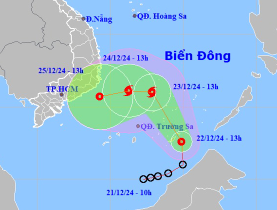
Location and direction of the tropical depression. Source: National Center for Hydro-Meteorological Forecasting
According to the National Center for Hydro-Meteorological Forecasting, at 1:00 p.m. on December 22, the center of the tropical depression was located at about 7.6 degrees North latitude; 114.9 degrees East longitude, in the South China Sea, about 350 km East Southeast of Truong Sa archipelago. The strongest wind near the center of the tropical depression was level 7, gusting to level 9; moving north at a speed of 20-25 km/hour.
Forecast by 1:00 p.m. on December 23, the center of the tropical depression is at about 11.0 degrees North latitude; 112.9 degrees East longitude, in the southwest sea area of the central East Sea. The strongest wind near the center of the tropical depression is level 8, gusting to level 10. Moving in the North-Northwest direction at a speed of 15-20 km/h, it is likely to strengthen into a storm. It will become the 10th storm in the East Sea in 2024.
Forecast as of 1 p.m. on December 24, the center of the storm is at approximately 11.1 degrees North latitude; 111.3 degrees East longitude, in the southwest sea area of the central East Sea. The strongest wind near the center of the storm is level 8, gusting to level 10. Moving west at a speed of 10 km/hour.
Over the next 48 to 72 hours, the storm will move west-southwest at about 10 km per hour and gradually weaken into a tropical depression.
The South East Sea area (including the Truong Sa archipelago) and the sea area southwest of the Central East Sea area have strong winds of level 6-7, the area near the storm's center has strong winds of level 8, gusts of level 10, waves 4-6 m high; rough seas.
Ships operating in the above mentioned dangerous areas are likely to be affected by storms, whirlwinds, strong winds and large waves.
From tonight to December 24, in the area from Da Nang to Khanh Hoa, there will be moderate rain, heavy rain, locally very heavy rain and thunderstorms with rainfall ranging from 30-80 mm, locally over 200 mm. In the early morning and on December 24, in the eastern Central Highlands, there will be moderate rain, heavy rain, locally very heavy rain and thunderstorms with rainfall ranging from 15-40 mm, locally over 70 mm.
On the night of December 24 and December 25, in the Central and South Central regions and the Eastern Central Highlands, there will be moderate rain, heavy rain, locally very heavy rain and thunderstorms with common rainfall of 50-100 mm, locally over 200 mm, especially in the Eastern Central Highlands, it will be common 30-60 mm, locally over 120 mm. From December 26, heavy rain is likely to gradually decrease.
Source: https://nld.com.vn/ap-thap-nhiet-doi-kha-nang-manh-len-thanh-bao-huong-vao-nam-bo-19624122216005052.htm









Comment (0)