

Path of storm BUALOI on the morning of September 26
According to the National Center for Hydro-Meteorological Forecasting, at 9:00 a.m. on September 26, the center of the storm was located at 12.3 degrees North latitude; 122.6 degrees East longitude, in the central region of the Philippines, with intensity of level 11, gusting to level 14.
Around tonight (September 26), storm BUALOI will enter the eastern sea area of the central East Sea, becoming storm number 10 in 2025.
After entering the East Sea, the storm moved in a West-Northwest direction at a very fast speed (average 30 km/h, twice as fast as normal storms). Around September 28, the storm headed towards the sea west of Hoang Sa special zone, with an intensity that could reach level 13, gusting to level 15.
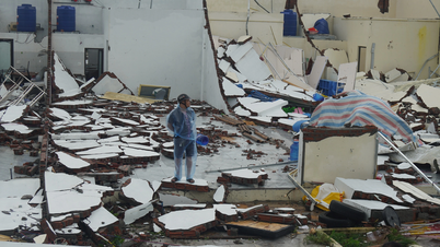
The storm is forecast to change direction, moving along the coast towards the North Central and Southern Northern Delta provinces, with direct impact from September 29. From September 28-30, the North, Thanh Hoa - Hue area will have very heavy rain.
In the next 24-72 hours, the storm may strengthen to level 12, gusting to level 15. Specifically, the storm will increase to level 11-12 on the morning of September 27 when moving over the East Sea. Favorable environmental conditions will allow the storm to move faster at a speed of 30-35 km/h, still maintaining a West-Northwest direction.
By 7am on September 28, the storm continued to strengthen to level 13, gusting to level 16. Natural disaster risk level 3 for the northern and central areas of the East Sea, Hoang Sa, and the southern sea areas of Quang Tri - Quang Ngai .
At 7:00 a.m. on September 29, the storm moved slower at a speed of about 25 km/h, with winds of level 12 and gusts of level 15.
Level 3 natural disaster risk for the Northwest region and the central East Sea, Hoang Sa, southern Quang Tri - Quang Ngai provinces, southern Bac Bo Gulf.
In the next 72-96 hours, the storm will continue to move rapidly in the West-Northwest direction, about 25 km per hour, gradually weakening.
Warning of dangerous weather at sea
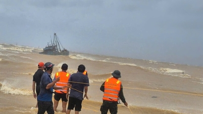
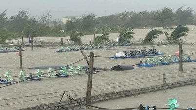
Due to the influence of storm BUALOI, from this afternoon (September 26), the eastern sea of the North and Central East Sea will have strong winds of level 6-7, then increasing to level 8-9, the area near the storm's center will have winds of level 10-12, gusting to level 15, waves 5-7 m high, and rough seas.
In addition, the sea area from Khanh Hoa to Can Tho city, the central and southern East Sea (including Truong Sa special zone) has southwest wind level 6, gusting to level 7-8; rough sea, waves 2-4 m high.
In the north of the North East Sea (including the north of Hoang Sa special zone), there will be winds of level 5, sometimes level 6, gusting to level 7-8; rough seas, waves 2-4 m high.
In the Gulf of Tonkin, the northern East Sea (including Hoang Sa special zone), the central and southern East Sea (including Truong Sa special zone), the sea area from southern Quang Tri to Ca Mau, from Ca Mau to An Giang and the Gulf of Thailand, there will be scattered showers and thunderstorms.
During thunderstorms there is a possibility of tornadoes, strong gusts of wind level 6-7, waves over 2m high.
The Hydrometeorological Agency warns that tomorrow (September 27) the northern and central East Sea (including Hoang Sa special zone) will have strong winds of level 9-10, the area near the storm's eye will have strong winds of level 11-12, gusting to level 15; waves 5-7 m high, and rough seas.
In the Gulf of Tonkin, from the evening and night of September 27, the northeast to north wind will gradually increase to level 6-7, gusting to level 8-9; the sea will be rough.
The sea area from southern Quang Tri to Quang Ngai in the evening and night of September 27 will have winds gradually increasing to level 6-8, gusting to level 9-10; rough seas.
The sea area from Khanh Hoa to Ho Chi Minh City, the southern East Sea area (including Truong Sa special zone) has strong southwest winds of level 6, gusting to level 7-8; waves 2-4 m high, rough seas.
Thu Cuc
Source: https://baochinhphu.vn/bao-bualoi-di-chuyen-nhanh-gap-doi-cac-con-bao-khac-102250926101526226.htm
![[Photo] General Secretary To Lam attends the ceremony to celebrate the 80th anniversary of the post and telecommunications sector and the 66th anniversary of the science and technology sector.](https://vphoto.vietnam.vn/thumb/1200x675/vietnam/resource/IMAGE/2025/9/29/8e86b39b8fe44121a2b14a031f4cef46)


![[Photo] National Assembly Chairman Tran Thanh Man chairs the 8th Conference of full-time National Assembly deputies](https://vphoto.vietnam.vn/thumb/1200x675/vietnam/resource/IMAGE/2025/9/29/2c21459bc38d44ffaacd679ab9a0477c)
![[Photo] General Secretary To Lam chairs the meeting of the Central Steering Committee on preventing and combating corruption, waste and negativity](https://vphoto.vietnam.vn/thumb/1200x675/vietnam/resource/IMAGE/2025/9/29/fb2a8712315d4213a16322588c57b975)
![[Photo] Many streets in Hanoi were flooded due to the effects of storm Bualoi](https://vphoto.vietnam.vn/thumb/1200x675/vietnam/resource/IMAGE/2025/9/29/18b658aa0fa2495c927ade4bbe0096df)


Comment (0)