
Storm Bualoi may make landfall at the same time as high tide (4-8am), causing storm surges in affected areas to be 1-2m high, and even higher in Thanh Hoa - Nghe An .
The above information is given at meeting to deploy response to storm No. 10 (Storm Bualoi) chaired by Deputy Prime Minister Tran Hong Ha on the morning of September 27.

According to the report of the Ministry of Agriculture and Environment, currently, storm number 10 is in the central East Sea with intensity of level 11-12, gusting to level 15.
The storm is moving much faster than initially forecast (about 35-40 km/h, nearly double the average speed), with strong storm intensity and wide range of influence, which can cause combined impacts of many types of natural disasters such as: strong winds, heavy rains, floods, flash floods, landslides and coastal flooding.
Storm No. 10 is not affected by cold air, the sea surface temperature is currently high (29°C), the circulation is wide and strong, the Southwest monsoon is also active, adding abundant moisture, so the storm will continue to strengthen, with no sign of decreasing much before making landfall.
When approaching the sea about 200 km from Da Nang (early morning of September 28), storm No. 10 is likely to reach its strongest intensity, level 13-14, gusting to level 15-16; reaching the shore it is still level 11-12, coastal level 12-13.
It is forecasted that from the afternoon of September 28, the coastal areas of Thanh Hoa - Thua Thien Hue, with a focus on Nghe An - Northern Quang Tri, will begin to experience strong winds of level 6-7, gradually increasing to level 12 when the storm makes landfall on the night of September 28 to the early morning of September 29. At sea, strong winds of level 8-9, near the storm center of level 12-13 from the early morning of September 28, waves 5-7 m high.
" Notably, storm No. 10 may coincide with high tide (4-8am), causing storm surges in the area from Binh Dinh (old) to Ha Tinh to reach 1-2m, with Thanh Hoa - Nghe An being higher. Combined with high tides and big waves, the risk of threatening dykes and coastal aquaculture areas is very high ," the report stated.
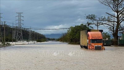
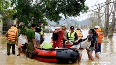
The storm's wide circulation also caused rain across the country from the afternoon of September 28 to September 30, with common rainfall of 100-300 mm, especially in Thanh Hoa - Ha Tinh 400 mm, locally 600 mm, with a very high risk of flooding, flash floods, and landslides.
After reaching the shore, the storm weakened into a tropical depression, continuing to cause heavy rain in Laos, floodwaters may accumulate in Thanh Hoa, Nghe An, and Ha Tinh areas.
Source: https://baolangson.vn/bao-bualoi-do-bo-vao-luc-trieu-cuong-song-bien-co-the-cao-5-7-m-5060160.html
![[Photo] General Secretary To Lam receives US Ambassador to Vietnam Marc Knapper](https://vphoto.vietnam.vn/thumb/1200x675/vietnam/resource/IMAGE/2025/9/29/c8fd0761aa184da7814aee57d87c49b3)
![[Photo] The 1st Congress of Phu Tho Provincial Party Committee, term 2025-2030](https://vphoto.vietnam.vn/thumb/1200x675/vietnam/resource/IMAGE/2025/9/30/1507da06216649bba8a1ce6251816820)

![[Photo] Solemn opening of the 12th Military Party Congress for the 2025-2030 term](https://vphoto.vietnam.vn/thumb/1200x675/vietnam/resource/IMAGE/2025/9/30/2cd383b3130d41a1a4b5ace0d5eb989d)

![[Photo] General Secretary To Lam, Secretary of the Central Military Commission attends the 12th Party Congress of the Army](https://vphoto.vietnam.vn/thumb/1200x675/vietnam/resource/IMAGE/2025/9/30/9b63aaa37ddb472ead84e3870a8ae825)


![[Photo] President Luong Cuong receives President of the Cuban National Assembly Esteban Lazo Hernandez](https://vphoto.vietnam.vn/thumb/1200x675/vietnam/resource/IMAGE/2025/9/30/4d38932911c24f6ea1936252bd5427fa)


Comment (0)