
Storm gusts at level 11 and moves at a speed of 15 - 20 km/h
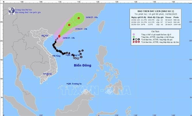
At 4:00 p.m. on June 14, the center of the storm was located at approximately 21.6 degrees North latitude; 110.2 degrees East longitude, in the southwest of Guangdong province (China). The strongest wind near the center of the storm was level 9 (75 - 88 km/h), gusting to level 11; moving northeast at a speed of 15 - 20 km/h.
Commenting specifically on the developments, Mr. Hoang Phuc Lam said that by 4:00 p.m. on June 15, the storm was moving northeast over Guangdong province (China) at a speed of about 20 km/h and gradually weakening into a tropical depression. The strongest wind of the tropical depression is level 6, gusting to level 8. The dangerous area is the northern sea of the Gulf of Tonkin and the northwest of the northern East Sea. Warning level 3 natural disaster risk.
At 4:00 a.m. on June 16, the tropical depression moved northeast over Fujian province (China) at a speed of about 20 - 25 km/h and gradually weakened into a low pressure area. Wind force below level 6.
Mr. Hoang Phuc Lam noted that due to the impact of the storm, the sea area east of the northern Gulf of Tonkin has strong winds of level 7 - 8, gusts of level 10, waves 2 - 4 m high, and rough seas.
The sea area west of the Northern Gulf of Tonkin (including Co To and Bach Long Vi island districts) and the northwest of the Northern East Sea area has strong winds of level 5, sometimes level 6, gusts of level 8, waves 2 - 3 m high, rough seas.
Ships operating in the above mentioned dangerous areas are likely to be affected by storms, whirlwinds, strong winds and large waves.
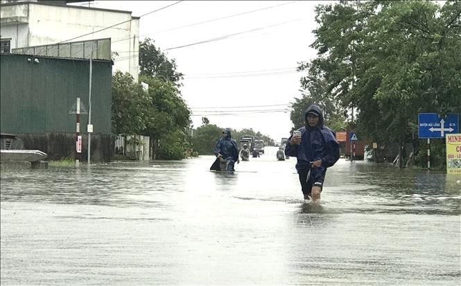
Risk of flash floods and landslides in Nghe An province
According to the National Center for Hydro-Meteorological Forecasting, from 5:30 p.m. to 11:30 p.m. on June 14, Nghe An province will continue to have rain with accumulated rainfall ranging from 15 to 30 mm, with some places exceeding 50 mm. There is a risk of flash floods on small rivers and streams, landslides on steep slopes in Nghe An province, especially in the districts of Que Phong, Quy Chau, Ky Son, Con Cuong, Tuong Duong, Quy Hop. Warning level of natural disaster risk due to flash floods, landslides, land subsidence due to heavy rain or level 1 flow.
Flash floods and landslides can have very negative impacts on the environment, threaten people's lives; cause local traffic congestion, affect the movement of vehicles; destroy civil and economic works, causing damage to production and socio -economic activities.
The Hydrometeorological Agency recommends that local authorities pay attention to reviewing bottlenecks and vulnerable locations in the area to take preventive and response measures.
From 1:00 p.m. to 4:00 p.m. on June 14, there was moderate to heavy rain in Nghe An province, such as: Chau Kim 1 with 58.4 mm, Nam Giai with 47.4 mm, Muong Noc with 44.8 mm...
Weather in different regions on the night of June 14 and June 15
In the Northwest, in the late afternoon and at night, there will be showers and thunderstorms in some places, with the possibility of tornadoes, lightning and strong gusts of wind during the thunderstorms; hot and sunny during the day, with some places experiencing intense heat. Light wind. Lowest temperature 24 - 27 degrees Celsius, some places below 23 degrees Celsius. Highest temperature 35 - 37 degrees Celsius, some places above 37 degrees Celsius, especially in Lai Chau and Dien Bien, 32 - 35 degrees Celsius.
In the Northeast, in the late afternoon and at night, there will be showers and thunderstorms in some places, with the possibility of tornadoes, lightning and strong gusts of wind during thunderstorms; hot and sunny during the day, with some places experiencing intense heat. Light wind. The lowest temperature is from 25 - 28 degrees Celsius, in mountainous areas, some places will be below 24 degrees Celsius. The highest temperature is from 35 - 37 degrees Celsius, some places will be above 37 degrees Celsius.
Hanoi capital: no rain at night, hot and sunny during the day, some places are very hot. Light wind. Lowest temperature from 26 - 28 degrees Celsius. Highest temperature from 35 - 37 degrees Celsius, some places above 37 degrees Celsius.
Provinces and cities from Thanh Hoa to Hue, in the late afternoon and at night, there will be scattered showers and thunderstorms, with the possibility of tornadoes, lightning and strong gusts of wind during thunderstorms; hot and sunny days, with some places experiencing severe heat. Southwesterly winds level 2-3. Lowest temperature from 24-27 degrees Celsius. Highest temperature from 35-37 degrees Celsius, with some places above 37 degrees Celsius.
In the provinces and cities from Da Nang to Binh Thuan, in the late afternoon and at night, there will be scattered showers and thunderstorms, with the possibility of tornadoes, lightning and strong gusts of wind; sunny days, some places will be hot. In the North, it will be hot and sunny, some places will be extremely hot. Southwest wind level 2 - 3, coastal areas level 3 - 4. Lowest temperature from 25 - 28 degrees Celsius. Highest temperature in the North from 35 - 37 degrees Celsius.
In the Central Highlands, there will be scattered showers and thunderstorms in the late afternoon and evening, with the possibility of tornadoes, lightning and strong gusts of wind; sunny during the day. Southwest wind level 2 - 3. Lowest temperature from 20 - 23 degrees Celsius. Highest temperature from 28 - 31 degrees Celsius, some places above 31 degrees Celsius.
In the late afternoon and evening, the Southern region will have scattered showers and thunderstorms, with the possibility of tornadoes, lightning and strong gusts of wind; sunny during the day. Southwest wind level 2 - 3. Lowest temperature from 24 - 27 degrees Celsius. Highest temperature from 31 - 34 degrees Celsius, some places above 34 degrees Celsius.
Source: https://baohaiduong.vn/bao-so-1-giam-cap-giat-cap-11-huong-ve-khu-vuc-tinh-quang-dong-trung-quoc-414076.html


Comment (0)