
Video of Mr. Hoang Phuc Lam, Deputy Director of the National Center for Hydro-Meteorological Forecasting, discussing storm No. 10:
Sir, could you please tell us the latest developments of storm No. 10, especially its location, direction of movement and intensity?
Due to the influence of storm No. 10, at Ly Son station (Quang Ngai), there were strong winds of level 7, gusts of level 8; Bac Trach station (Quang Tri) had strong winds of level 8, gusts of level 10; Hoanh Son station ( Ha Tinh ) had strong winds of level 6, gusts of level 9; Van Ly station (Ninh Binh) had strong winds of level 7, gusts of level 9; Hon Ngu station (Nghe An) had strong winds of level 6, gusts of level 8; Con Co station (Quang Tri) had strong winds of level 7, gusts of level 10; Bach Long Vi station had strong winds of level 7, gusts of level 9...
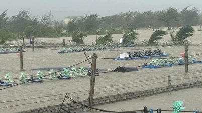
As of 4 p.m. on September 28, some places in the island and coastal areas have observed strong winds of level 7-8, gusts of level 9. Currently, the place with the strongest winds is the area north of Quang Tri, Bac Trach commune in the old Quang Binh , strong winds of level 8, gusts of level 10. In addition, other areas commonly have winds of level 7, gusts of level 9. The center of the storm is located at about 17.4 degrees North latitude; 107.7 degrees East longitude, about 120 km east of North Quang Tri. The strongest wind is level 12 (118 - 133 km/h), gusts of level 15. It is forecasted that in the next 3 hours, the storm will move in the West Northwest direction, at a speed of about 20 - 25 km/h.
So, currently, the storm is moving at a very fast speed of 25 km/h. However, compared to yesterday, this speed is a bit slower. With the slower movement, the impact will last about an hour longer than the forecast on September 27. Specifically, looking at the trajectory forecast, the time the storm's eye can reach the shore will be around midnight, that is, from 0-2 am on September 29. However, the area affected by strong winds and rain is an area of several hundred kilometers around the eye of the storm. From the evening and night of September 28, the wind will start to strengthen and peak from about 8 pm onwards with very strong winds and heavy rain. This situation can last until 4-5 am on September 30.
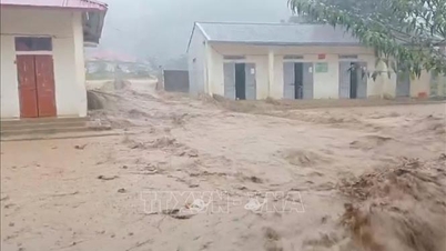
The most affected areas are all provinces from Thanh Hoa to the North of Quang Tri. The storm moves from South to North, so the impact of the storm will also extend from South to North. At present, the provinces from Quang Tri to Da Nang are being affected by heavy rain and strong winds. On the evening of September 28, heavy rain and strong winds will spread to Ha Tinh, Nghe An and Thanh Hoa. From midnight to morning, it will extend to the provinces of the Northern Delta, including the capital Hanoi and then the midlands and mountainous areas.
The mountainous midland provinces will be mainly affected by rain. It is expected that the storm will weaken by morning to noon on September 30, so only post-storm rain will remain. These areas are warned of the risk of flash floods and landslides.
Sir, is it dangerous if the storm moves slowly?
If the storm slows down, the time it is affected by strong winds and heavy rain will increase. With meteorological expertise, the slowing down of the storm will also pose risks of structural changes, changes in direction of movement and the possible appearance of new factors. However, with the storm moving at a speed of 25 km/h, it is still fast, and does not pose many risks of structural changes or changes in direction. If the storm slows down to 5-10 km/h, then it is worrisome.
What should localities pay attention to in the Level 4 multi-disaster risk warning? What time frame will the wind impact the strongest and which locality is at greatest risk, sir?
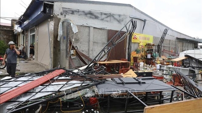
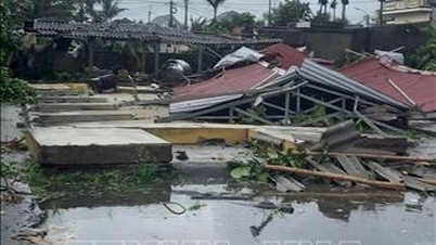
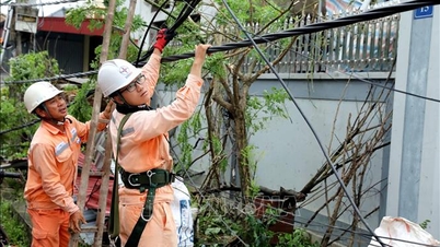
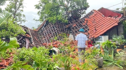
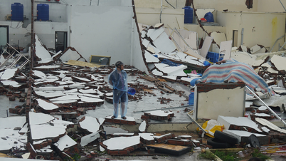
During storm No. 10, the risk of natural disasters at level 4 is determined based on the possibility of strong winds of level 10 - 12 in coastal areas of Thanh Hoa - Northern Quang Tri provinces along with the risk of very heavy rain with rainfall of over 200mm/3 hours. Localities need to pay attention to strong winds of level 10 - 12, which can cause trees to fall in large numbers, houses - especially non-solid houses - can have their roofs blown off, electric poles broken... causing great damage. Heavy rain can cause urban flooding, flooding of traffic routes in low-lying areas, flash floods and landslides in mountainous areas...
The area from South Quang Tri to Hue City has strong winds of level 6 - 7 (trees shake, difficult to go against the wind), gusts of level 8 - 9. The focus of rain is the area from Thanh Hoa to North Quang Tri, winds gradually increase to level 6 - 7, then increase to level 8 - 9, the area near the storm center has winds of level 10 - 12 (wind force can knock down trees, houses, electric poles, causing very heavy damage), gusts of level 14. The coastal area from Quang Ninh to Ninh Binh has winds gradually increase to level 6 - 7, gusts of level 8 - 9, in some places level 8, gusts of level 10.
From the afternoon of September 28 to September 30, in the North and the area from Thanh Hoa to Da Nang City, there will be moderate rain, heavy rain, and very heavy rain in some places with total rainfall ranging from 100 - 300 mm, locally over 450 mm; in the Northern Delta, Phu Tho, the South of Son La and Lao Cai provinces, from Thanh Hoa to the North of Quang Tri, there will be heavy to very heavy rain with total rainfall ranging from 200 - 400 mm, locally over 600 mm. Warning of the risk of heavy rain (over 200 mm/3 hours).
Sir, what will the rain situation be like in Hanoi?
The Hanoi area will be affected by rain later. On September 28, Hanoi will have rain, but it will only be on the far edge of the storm, not the time of heaviest rain and strongest winds due to the influence of storm No. 10.
The time when the wind is strongest in Hanoi is midnight to early morning, that is, around 4-5 am tomorrow (September 29) will be the time when Hanoi has the strongest wind, wind intensity is around level 4, level 5, gusting to level 6-7.
Thus, the Hanoi area will have rain from around 7pm on September 28, the time of heaviest rain and it may last until the afternoon of September 29 and into the early morning of September 29, when people go to work, there will be heavy rain.
So, what warnings do you have about the rain and flood situation for the areas, sir?
In the past 24 hours (from 1:00 p.m. on September 27 to 1:00 p.m. on September 28), the provinces from Thanh Hoa to Quang Ngai had moderate rain, heavy rain, and very heavy rain in some places such as: Cam Luong 62.6 mm (Thanh Hoa); Yen Thuong 110.2 mm (Nghe An); Huong Vinh 173 mm (Ha Tinh); Ta Rut 275 mm (Quang Tri); Huong Nguyen 490.4 mm (Hue City); Que Phuoc 206 mm (Da Nang City); Binh Khuong 114.8 mm (Quang Ngai)...
In the next 3-6 hours, the above provinces will continue to have rain with common accumulated rainfall as follows: from Thanh Hoa to Quang Tri from 50-90 mm, some places over 100 mm; Hue city from 30-50 mm, some places over 80 mm; from Da Nang city to Quang Ngai from 10-30 mm, some places over 50 mm.
In the next 6 hours, there is a risk of flash floods on small rivers and streams, and landslides on steep slopes. Warning level of natural disaster risk due to flash floods, landslides, and land subsidence due to heavy rain or water flow: Level 1, Hue City level 2.
Flash floods and landslides can have negative impacts on the environment, threaten people's lives; cause local traffic congestion, affect the movement of vehicles; destroy civil works, and cause damage to production and socio-economic activities.
Thank you very much!
Source: https://baotintuc.vn/xa-hoi/bao-so-10-do-bo-dat-lien-tu-dem-299-canh-bao-gio-manh-mua-lon-o-nhieu-noi-20250928170651627.htm
![[Photo] General Secretary To Lam chairs the meeting of the Central Steering Committee on preventing and combating corruption, waste and negativity](https://vphoto.vietnam.vn/thumb/1200x675/vietnam/resource/IMAGE/2025/9/29/fb2a8712315d4213a16322588c57b975)

![[Photo] Many streets in Hanoi were flooded due to the effects of storm Bualoi](https://vphoto.vietnam.vn/thumb/1200x675/vietnam/resource/IMAGE/2025/9/29/18b658aa0fa2495c927ade4bbe0096df)
![[Photo] General Secretary To Lam attends the ceremony to celebrate the 80th anniversary of the post and telecommunications sector and the 66th anniversary of the science and technology sector.](https://vphoto.vietnam.vn/thumb/1200x675/vietnam/resource/IMAGE/2025/9/29/8e86b39b8fe44121a2b14a031f4cef46)
![[Photo] General Secretary To Lam receives US Ambassador to Vietnam Marc Knapper](https://vphoto.vietnam.vn/thumb/1200x675/vietnam/resource/IMAGE/2025/9/29/c8fd0761aa184da7814aee57d87c49b3)
![[Photo] National Assembly Chairman Tran Thanh Man chairs the 8th Conference of full-time National Assembly deputies](https://vphoto.vietnam.vn/thumb/1200x675/vietnam/resource/IMAGE/2025/9/29/2c21459bc38d44ffaacd679ab9a0477c)


Comment (0)