
According to the National Center for Hydro-Meteorological Forecasting, by 7am on July 7, the storm is forecast to move in a north-northeast direction at a speed of 15-20km/h. The center of the storm will be located in the sea of Fujian province (China), at about 25.0 degrees North latitude; 119.9 degrees East longitude. The intensity remains at level 11, gusting to level 13.
Dangerous area: North of latitude 20.0 degrees North and East of longitude 116.5 degrees East.
Disaster risk level: Level 3 – affects the Northeast sea area of the North East Sea.
At 7:00 a.m. on July 8, the storm continued to move in a north-northeast direction, moving at about 15 km/h and showing signs of weakening. The center of the storm was at about 28.0 degrees North latitude; 121.6 degrees East longitude, over the sea of Zhejiang province (China). Winds decreased to level 10, gusting to level 12.
The danger zone moves north of latitude 23.5 degrees North and east of longitude 118.0 degrees East.
At 7:00 a.m. on July 9, the storm changed direction to the West, at a speed of about 10 km/h, and weakened into a low pressure area. The center of the low pressure area was located at about 27.9 degrees North latitude; 119.4 degrees East longitude, on the mainland of Zhejiang province (China). Wind intensity decreased to below level 6.
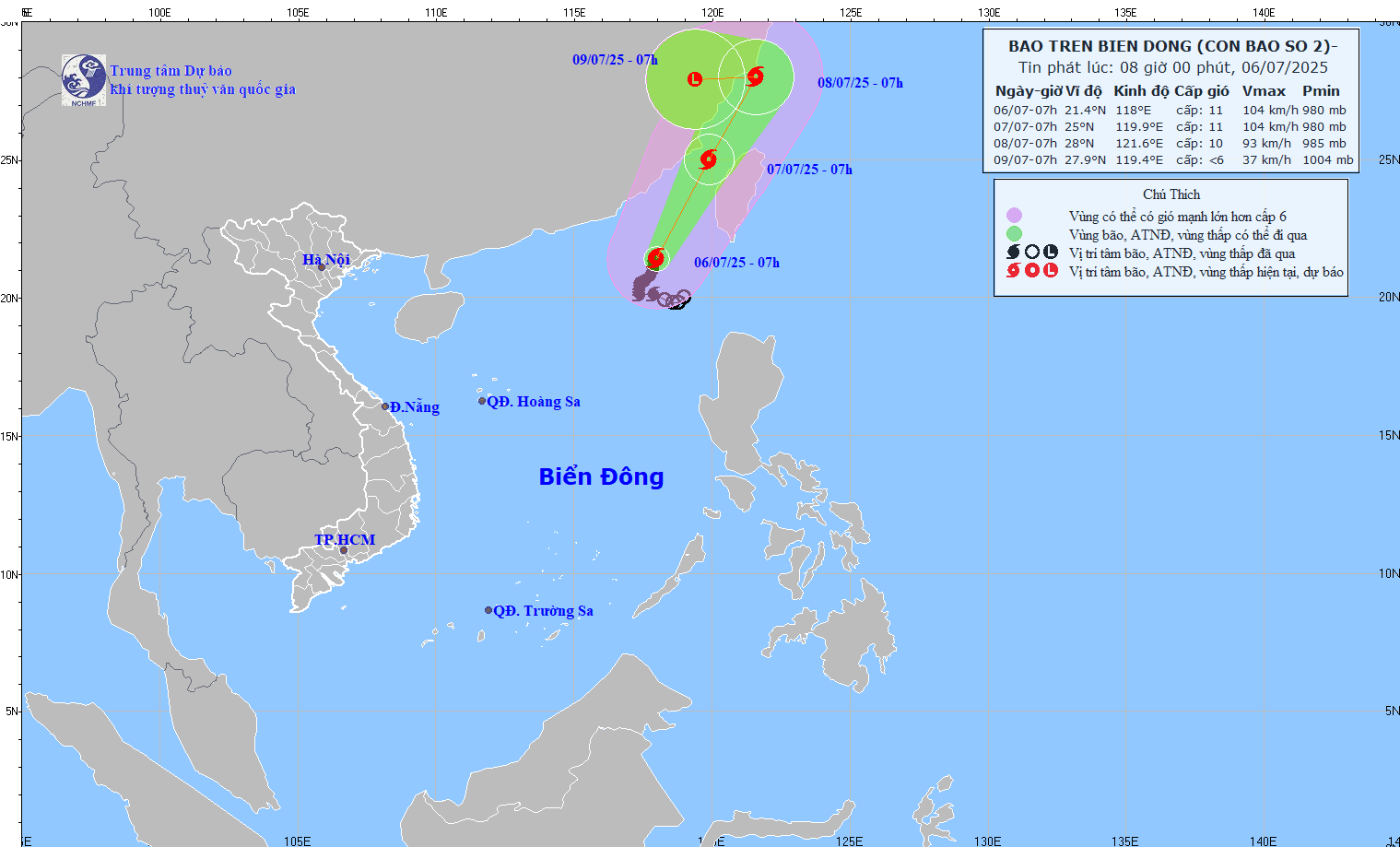
Marine Impact Warning: Waves up to 6 meters high, risk of thunderstorms and strong winds
Due to the influence of storm No. 2, the northeastern sea area of the North East Sea has stormy rain, strong winds of level 7-9. Particularly near the center of the storm, strong winds of level 10-11, gusts of level 13, waves from 4.0-6.0 meters high, rough seas.
Vessels and activities at sea in the danger zone need to pay close attention. There is a high risk of thunderstorms, tornadoes, strong winds and large waves. Authorities advise vessels to immediately seek safe shelter, closely monitor weather forecasts and avoid entering storm-dangerous areas.
Source VOV
View original linkSource: https://baotayninh.vn/bao-so-2-gay-mua-bao-tren-bien-dong-bien-dong-song-cao-6-met-a192088.html


![[Maritime News] Treasury Department Targets Diverse Networks Facilitating Iran's Oil Trade](https://vphoto.vietnam.vn/thumb/402x226/vietnam/resource/IMAGE/2025/7/14/43150a0498234eeb8b127905d27f00b6)


Comment (0)