
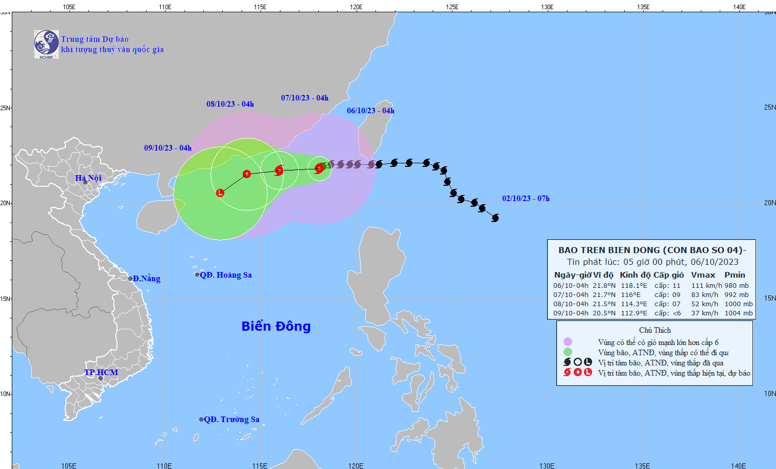
At 4:00 AM on October 6th, the typhoon's center was located at approximately 21.8 degrees North latitude and 118.1 degrees East longitude, in the northeastern part of the South China Sea, about 430km east-southeast of Hong Kong (China). The strongest winds near the center of the typhoon were at level 11 (103-117 km/h), with gusts up to level 14, moving westward at a speed of about 10 km/h.
Forecasts indicate that by 4:00 AM on October 7th, the storm will be approximately 210km southeast of Hong Kong (China), with maximum wind speeds near the center reaching level 9, gusting to level 12, moving westward at a speed of about 10km/h and gradually weakening.
By 4:00 AM on October 8th, the storm was approximately 90km south of Hong Kong (China), with maximum sustained winds near its center reaching levels 6-7, gusting to level 9. It was moving westward at a speed of about 5-10km per hour and had weakened into a tropical depression.
Then, at 4:00 AM on October 9th, the storm was approximately 260km south-southwest of Hong Kong (China). The strongest winds near the storm's center had decreased to below level 6, moving west-southwest at a speed of about 5-10km/h and weakening into a low-pressure area.
In the northeastern part of the South China Sea, winds are strong, reaching levels 7-9, with winds near the storm's center reaching levels 10-11, gusting up to level 14; the sea is extremely rough. Wave heights in the North China Sea are 2-4m, while in the northeastern area waves reach 4-6m, and near the storm's center waves reach 6-8m.
Source


![[Video] Sunset at Lap An Lagoon – Where the sun sets over the fishing nets](https://vphoto.vietnam.vn/thumb/1200x675/vietnam/resource/IMAGE/2026/05/31/1780192137701_beach-landscape-sea-water-nature-grass-745871-pxhere-com.jpeg)


Comment (0)